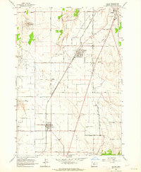
1963 Map of Culver
USGS Topo · Published 1964About this map
Agricultural development on the Little Agency Plains defines this mid-century view of Jefferson County. The towns of Culver, Metolius, and the southern edge of Madras are connected by the Spokane Portland and Seattle railroad and a rigid grid of local roads like Belmont Lane and Iris Drive. This layout highlights the region's reliance on irrigation, evidenced by the North Unit Main Canal and numerous siphons feeding the fields from the east, while the western edge drops dramatically into the basalt canyons of The Cove Palisades. Genealogists will find the German Cemetery and Hale Cemetery preserved among the farm plots. The map also captures local industry and infrastructure through features like the Brewer Airstrip, Haystack Dam, and several cinder pits, showing how the volcanic landscape of Round Butte was utilized for practical materials.
Find a feature on this map
50 named features on this map. Tap any name to fly to it.
Don’t see what you’re looking for? This feature index may not catch every label — zoom into the map to look around manually.
Map Details
Editions of this 1963 Culver Map
This is the sole edition of this map. No revisions or reprints were ever made.
Other maps of this area

1926 · Bend
USGS Topo · 1:125,000

1928 · Madras
USGS Topo · 1:125,000

1929 · Bend
USGS Topo · 1:125,000

1931 · Madras
USGS Topo · 1:125,000

1955 · Bend
USGS Topo · 1:250,000

1957 · Bend
USGS Topo · 1:250,000

1958 · Bend
USGS Topo · 1:250,000

1962 · Opal City
USGS Topo · 1:24,000
1962 · Gray Butte
USGS Topo · 1:24,000
1962 · Steelhead Falls
USGS Topo · 1:24,000