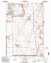
1992 Map of Culver
USGS Topo · Published 1998About this map
Agricultural and irrigation patterns dominate this high desert landscape on the edge of Madras. The map illustrates the complex interplay of water management and land use within the high-altitude terrain of Central Oregon. A dense network of lateral canals, siphons, and irrigation ditches crisscrosses the sectioned farmland, highlighting the infrastructure required to support the local economy. To the west, the transition into managed public lands becomes evident, providing a clear visual record of the boundary between private agricultural plots and the protected natural environment as it was managed in the early 1990s.
Find a feature on this map
1 named feature on this map. Tap any name to fly to it.
Don’t see what you’re looking for? This feature index may not catch every label — zoom into the map to look around manually.
Map Details
Editions of this 1992 Culver Map
This is the sole edition of this map. No revisions or reprints were ever made.
Other maps of this area

1926 · Bend
USGS Topo · 1:125,000

1928 · Madras
USGS Topo · 1:125,000

1929 · Bend
USGS Topo · 1:125,000

1931 · Madras
USGS Topo · 1:125,000

1955 · Bend
USGS Topo · 1:250,000

1957 · Bend
USGS Topo · 1:250,000

1958 · Bend
USGS Topo · 1:250,000

1962 · Opal City
USGS Topo · 1:24,000
1962 · Gray Butte
USGS Topo · 1:24,000
1962 · Steelhead Falls
USGS Topo · 1:24,000