1980s Maps of Three Pines, Oregon
Explore 2 historic maps of Three Pines from the 1980s. These maps offer a rare glimpse into what life looked like during the 1980s — showing old roads, neighborhoods, homes, and landmarks that have changed or disappeared over time.
Whether you're researching your family's past, planning a metal detecting trip, or studying how Three Pines's landscape evolved across the 1980s, these high-resolution maps are a powerful tool for exploring the history of this region.
- Focus on a specific era: All maps on this page are from the 1980s, giving you a focused view of this time period.
- See what’s changed: Compare century-old streets, trails, and buildings to today's modern landscape using overlays and satellite layers.
- Research with precision: Use these maps for genealogy, historical research, land use analysis, or educational projects.
- View, download, or print: Maps are fully viewable online in high resolution, and can be downloaded or printed for your own records.
Start exploring Three Pines's history through authentic maps from the 1980s. This is your window into the past.
Three Pines, OR maps
(2)- 1986 Map of Merlin
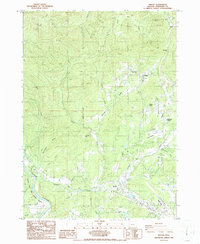 1986 Merlin1986 Print · USGSJosephine County in the mid-1980s shows a landscape of mountain passes and river valleys during a period of rural development. Researchers can trace the proximity of the Merlin Sanitarium to Merlin or locate industrial sites like the Copper Queen Mine and JOSEPHINE COUNTY AIRPORT.
 - 1989 Map of Canyonville
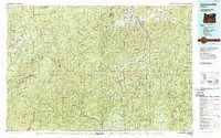 1989 Canyonville1989 Print · USGSSouthern Oregon's timber and rail corridors come into focus during the late eighties as communities like Canyonville and Riddle anchor the local economy. Researchers can trace the path of the Southern Pacific Railroad and locate early settlements such as Placer, Leland, and Sunny Valley.2 unique versions available
End of results
Showing maps 1-2 of 2
Top cities near Three Pines
Frequently asked questions
- What are the different types of historical maps available for Three Pines?
- What is the oldest map of Three Pines?
- Where can I purchase historical maps of Three Pines for my home or office?
- Where can I download high-res historical maps of Three Pines?
- Are there historical topographic maps available for Three Pines?
- Is there historical aerial imagery available for Three Pines?
- Where are historical maps of Three Pines sourced from?