1900s (20th Century) Maps of Chemult, Oregon
Explore 9 historic maps of Chemult from the 1900s (20th Century). These maps offer a rare glimpse into what life looked like during the 1900s — showing old roads, neighborhoods, homes, and landmarks that have changed or disappeared over time.
Whether you're researching your family's past, planning a metal detecting trip, or studying how Chemult's landscape evolved across the 1900s, these high-resolution maps are a powerful tool for exploring the history of this region.
- Focus on a specific era: All maps on this page are from the 1900s, giving you a focused view of this time period.
- See what’s changed: Compare century-old streets, trails, and buildings to today's modern landscape using overlays and satellite layers.
- Research with precision: Use these maps for genealogy, historical research, land use analysis, or educational projects.
- View, download, or print: Maps are fully viewable online in high resolution, and can be downloaded or printed for your own records.
Start exploring Chemult's history through authentic maps from the 1900s. This is your window into the past.
Chemult, OR maps
(9)- 1935 Map of Chemult
 1935 Chemult1935 Print · USGSUpper Klamath County in the mid-1930s was a landscape defined by industrial logging camps and high-desert rail sidings. Researchers can locate vanished timber operations like Pelican Bay Lumber Co Camp No 2 and remote outposts such as Rosedale and Paunina.5 unique versions available
 - 1941 Map of Chemult
 1941 Chemult1941 Print · USGSUpper Klamath County in the mid-1930s is a landscape of high-altitude timber camps and critical rail junctions. Genealogy researchers can trace remote family holdings and logging outposts like Hoey Ranch, Beaver Marsh, and Lumber Camp 2 along the competing railroad lines.2 unique versions available
 - 1955 Map of Crescent, 1963 Print
 1955 Crescent1963 Print · USGSCentral Oregon in the mid-1950s was a landscape of dense national forests and high desert expanses. Researchers can trace timber-era settlements like Gilchrist and Crescent or locate remote outposts such as Stauffer and Millican near the Wagontire Mountains.3 unique versions available
 - 1957 Map of Crescent
 1957 Crescent1957 Print · USGSCentral Oregon’s high desert and volcanic rim are captured here in the late fifties, showing the region before the modernization of its wilderness corridors. Genealogists and local historians can trace rail-line outposts like Chemult and the early boundaries of the Klamath Indian Reservation.
 - 1958 Map of Crescent
 1958 Crescent1958 Print · USGSCentral Oregon’s volcanic high desert and timber country are captured here in the mid-fifties, from the peaks of the Cascades to the arid basins. Researchers can trace the lines of the Southern Pacific RR, the northern reaches of the Klamath Indian Reservation, and remote outposts like Fort Rock.
 - 1967 Map of Chemult, 1970 Print
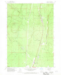 1967 Chemult1970 Print · USGSChemult and the surrounding national forest lands are shown in the late 1960s as a vital junction for the Southern Pacific and Great Northern railroads. Researchers can trace the industrial footprint of the era through the Pumice Pit, Willow Campground, and the remote Diamond Lake (Siding).
 - 1970 Map of Crescent, 1973 Print
 1970 Crescent1973 Print · USGSCentral Oregon in the early seventies reveals a landscape of volcanic peaks and timber outposts connected by the Southern Pacific rail line. Researchers can trace the layout of Christmas Valley, locate Cabin Lake Ranger Station, and explore the geological footprint of Newberry Crater.
 - 1979 Map of Crescent, 1994 Print
 1979 Crescent1994 Print · USGSHigh-altitude timber country and volcanic craters define this region of the Oregon interior during the late seventies. Researchers can trace the rail lines of the Southern Pacific and Burlington Northern past Chemult, Crescent, and the unique geological formation at Hole in the Ground.
 - 1999 Map of Chemult, 2002 Print
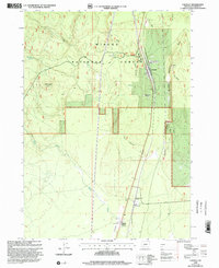 1999 Chemult2002 Print · USGSHigh country rail and timber operations define this Klamath County landscape at the close of the nineties. Genealogists and historians can trace the infrastructure of Chemult, the Diamond Lake (Siding), and the isolated Beaver Marsh airfield.
End of results
Showing maps 1-9 of 9
Frequently asked questions
- What are the different types of historical maps available for Chemult?
- What is the oldest map of Chemult?
- Where can I purchase historical maps of Chemult for my home or office?
- Where can I download high-res historical maps of Chemult?
- Are there historical topographic maps available for Chemult?
- Is there historical aerial imagery available for Chemult?
- Where are historical maps of Chemult sourced from?