1940s Maps of Crowfoot, Oregon
Explore 2 historic maps of Crowfoot from the 1940s. These maps offer a rare glimpse into what life looked like during the 1940s — showing old roads, neighborhoods, homes, and landmarks that have changed or disappeared over time.
Whether you're researching your family's past, planning a metal detecting trip, or studying how Crowfoot's landscape evolved across the 1940s, these high-resolution maps are a powerful tool for exploring the history of this region.
- Focus on a specific era: All maps on this page are from the 1940s, giving you a focused view of this time period.
- See what’s changed: Compare century-old streets, trails, and buildings to today's modern landscape using overlays and satellite layers.
- Research with precision: Use these maps for genealogy, historical research, land use analysis, or educational projects.
- View, download, or print: Maps are fully viewable online in high resolution, and can be downloaded or printed for your own records.
Start exploring Crowfoot's history through authentic maps from the 1940s. This is your window into the past.
Crowfoot, OR maps
(2)- 1940 Map of Lebanon
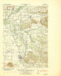 1940 Lebanon1940 Print · USGSLinn County agriculture and timber transit thrived on the eve of the 1940s, centered on the growing hub of Lebanon. Genealogists and historians can trace dozens of rural school districts and old burial grounds, including Jefferson Cemetery, Rollins Mill, and the Southern Pacific rail stops.
 - 1944 Map of Lebanon
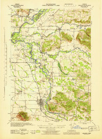 1944 Lebanon1944 Print · USGSMid-valley Oregon life comes into focus in the 1940s, as rail lines and river forks connect the growing mills and rural schoolhouses of Linn County. Researchers can trace the early layouts of Lebanon and Scio, or locate ancestral sites at Jefferson Cem and Gore Sch.
End of results
Showing maps 1-2 of 2
Top cities near Crowfoot
- Albany historical maps
- Lebanon historical maps
- Sweet Home historical maps
- Jefferson historical maps
- Brownsville historical maps
- Tangent historical maps
See more
Frequently asked questions
- What are the different types of historical maps available for Crowfoot?
- What is the oldest map of Crowfoot?
- Where can I purchase historical maps of Crowfoot for my home or office?
- Where can I download high-res historical maps of Crowfoot?
- Are there historical topographic maps available for Crowfoot?
- Is there historical aerial imagery available for Crowfoot?
- Where are historical maps of Crowfoot sourced from?