1960s Maps of Lebanon, Oregon
Explore 5 historic maps of Lebanon from the 1960s. These maps offer a rare glimpse into what life looked like during the 1960s — showing old roads, neighborhoods, homes, and landmarks that have changed or disappeared over time.
Whether you're researching your family's past, planning a metal detecting trip, or studying how Lebanon's landscape evolved across the 1960s, these high-resolution maps are a powerful tool for exploring the history of this region.
- Focus on a specific era: All maps on this page are from the 1960s, giving you a focused view of this time period.
- See what’s changed: Compare century-old streets, trails, and buildings to today's modern landscape using overlays and satellite layers.
- Research with precision: Use these maps for genealogy, historical research, land use analysis, or educational projects.
- View, download, or print: Maps are fully viewable online in high resolution, and can be downloaded or printed for your own records.
Start exploring Lebanon's history through authentic maps from the 1960s. This is your window into the past.
Lebanon, OR maps
(5)- 1960 Map of Salem, 1968 Print
 1960 Salem1968 Print · USGSThe Willamette Valley and the surrounding mountain ranges are shown here in the 1960s during a period of significant reservoir construction. Genealogists and historians can trace rail lines like the Oregon Electric and find communities from Lincoln City on the coast to Sweet Home and Mill City in the foothills.2 unique versions available
 - 1962 Map of Salem
 1962 Salem1962 Print · USGSThe Willamette Valley and the surrounding Oregon ranges are captured here in the early sixties, showing the vital growth of the state's primary agricultural and academic corridor. Researchers can trace the mid-century footprints of Oregon State University and the University of Oregon, alongside rural landmarks like Camp Adair and Black Butte Mine.
 - 1963 Map of Salem
 1963 Salem1963 Print · USGSMid-century Oregon comes into focus as the Willamette Valley’s timber and agricultural industries meet the growing campuses of Oregon State University and the University of Oregon. Researchers can trace old rail lines like the Oregon Electric Railway and locate family plots at Siletz Cem or Dallas Cem.
 - 1969 Map of Lebanon, 1971 Print
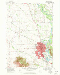 1969 Lebanon1971 Print · USGSThe Linn County landscape around Lebanon comes into sharp focus during the late sixties, showing a vital crossroads of river, rail, and canal. Genealogists and historians can trace family locations near landmarks like Peterson Butte, Tennessee Sch, and Pioneer Cem.3 unique versions available
 - 1969 Map of Onehorse Slough, 1971 Print
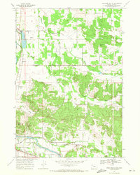 1969 Onehorse Slough1971 Print · USGSLinn County agriculture and river life are captured here in the late sixties as the valley transitioned toward modern development. Genealogists and local historians can trace family locations near Berlin, the Providence Cemetery, and the Hamilton Creek School.2 unique versions available
End of results
Showing maps 1-5 of 5
Top cities near Lebanon
- Albany historical maps
- Sweet Home historical maps
- Jefferson historical maps
- Brownsville historical maps
- Tangent historical maps
- Halsey historical maps
See more
Frequently asked questions
- What are the different types of historical maps available for Lebanon?
- What is the oldest map of Lebanon?
- Where can I purchase historical maps of Lebanon for my home or office?
- Where can I download high-res historical maps of Lebanon?
- Are there historical topographic maps available for Lebanon?
- Is there historical aerial imagery available for Lebanon?
- Where are historical maps of Lebanon sourced from?