
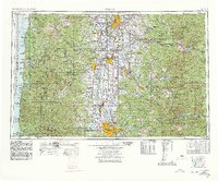
1960 Map of Salem
USGS Topo · Published 1968About this map
The Willamette River valley serves as the central corridor of this 1960s study, connecting major regional centers from Salem and Corvallis down to Eugene and Springfield. This mid-century landscape is defined by its massive water-control projects, featuring several prominent reservoirs including Fern Ridge Reservoir, Detroit Reservoir, and Lookout Point Reservoir. These artificial water bodies, along with the North Santiam River and South Santiam River systems, illustrate the era's significant hydraulic engineering efforts across the valley.
Find a feature on this map
83 named features on this map. Tap any name to fly to it.
Don’t see what you’re looking for? This feature index may not catch every label — zoom into the map to look around manually.
Map Details
Editions of this 1960 Salem Map
2 editions found
Other maps of this area

1909 · Harrisburg
USGS Topo · 1:31,680

1909 · Rowland
USGS Topo · 1:31,680

1909 · Elmira
USGS Topo · 1:62,500

1910 · Eugene
USGS Topo · 1:62,500
1911 · Brownsville
USGS Topo · 1:31,680
1911 · Lebanon
USGS Topo · 1:31,680

1911 · Monroe
USGS Topo · 1:31,680

1911 · Tangent
USGS Topo · 1:31,680
1911 · Inavale
USGS Topo · 1:31,680

1912 · Jefferson
USGS Topo · 1:31,680