1970s Maps of West Scio, Oregon
Explore 1 historic maps of West Scio from the 1970s. These maps offer a rare glimpse into what life looked like during the 1970s — showing old roads, neighborhoods, homes, and landmarks that have changed or disappeared over time.
Whether you're researching your family's past, planning a metal detecting trip, or studying how West Scio's landscape evolved across the 1970s, these high-resolution maps are a powerful tool for exploring the history of this region.
- Focus on a specific era: All maps on this page are from the 1970s, giving you a focused view of this time period.
- See what’s changed: Compare century-old streets, trails, and buildings to today's modern landscape using overlays and satellite layers.
- Research with precision: Use these maps for genealogy, historical research, land use analysis, or educational projects.
- View, download, or print: Maps are fully viewable online in high resolution, and can be downloaded or printed for your own records.
Start exploring West Scio's history through authentic maps from the 1970s. This is your window into the past.
West Scio, OR maps
(1)- 1970 Map of Crabtree, 1972 Print
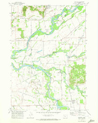 1970 Crabtree1972 Print · USGSThe Santiam River valley in the early seventies shows a landscape defined by its waterways and rail connections. Local researchers can trace old road networks like Old Sucker Road and find landmarks such as the Riverview Community Hall and several Covered Bridge crossings.2 unique versions available
End of results
Showing maps 1-1 of 1
Top cities near West Scio
- Salem historical maps
- Albany historical maps
- Lebanon historical maps
- Stayton historical maps
- Aumsville historical maps
- Sublimity historical maps
See more
Frequently asked questions
- What are the different types of historical maps available for West Scio?
- What is the oldest map of West Scio?
- Where can I purchase historical maps of West Scio for my home or office?
- Where can I download high-res historical maps of West Scio?
- Are there historical topographic maps available for West Scio?
- Is there historical aerial imagery available for West Scio?
- Where are historical maps of West Scio sourced from?