1990s Maps of Idanha, Oregon
Explore 2 historic maps of Idanha from the 1990s. These maps offer a rare glimpse into what life looked like during the 1990s — showing old roads, neighborhoods, homes, and landmarks that have changed or disappeared over time.
Whether you're researching your family's past, planning a metal detecting trip, or studying how Idanha's landscape evolved across the 1990s, these high-resolution maps are a powerful tool for exploring the history of this region.
- Focus on a specific era: All maps on this page are from the 1990s, giving you a focused view of this time period.
- See what’s changed: Compare century-old streets, trails, and buildings to today's modern landscape using overlays and satellite layers.
- Research with precision: Use these maps for genealogy, historical research, land use analysis, or educational projects.
- View, download, or print: Maps are fully viewable online in high resolution, and can be downloaded or printed for your own records.
Start exploring Idanha's history through authentic maps from the 1990s. This is your window into the past.
Idanha, OR maps
(2)- 1991 Map of North Santiam River, 1993 Print
 1991 North Santiam River1993 Print · USGSMarion and Linn counties come into focus in the early 1990s as the Santiam River valley transitions from the Willamette Valley floor to the Cascade peaks. Researchers can trace timber and rail history through Mill City, locate family landmarks near Stayton, or explore the boundaries of Silver Falls State Park.
 - 1994 Map of Idanha, 1998 Print
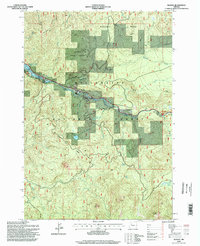 1994 Idanha1998 Print · USGSThe mountain settlement of Idanha and the upper reaches of Detroit Lake are captured here during the mid-1990s. Researchers can trace the river-valley economy through local landmarks like the Gaging Station, Whispering Falls, and the Santiam State Forest.
End of results
Showing maps 1-2 of 2
Top cities near Idanha
Top neighborhoods of Idanha
Frequently asked questions
- What are the different types of historical maps available for Idanha?
- What is the oldest map of Idanha?
- Where can I purchase historical maps of Idanha for my home or office?
- Where can I download high-res historical maps of Idanha?
- Are there historical topographic maps available for Idanha?
- Is there historical aerial imagery available for Idanha?
- Where are historical maps of Idanha sourced from?