1900s (20th Century) Maps of New Idanha, Idanha
Explore 11 historic maps of New Idanha from the 1900s (20th Century). These maps offer a rare glimpse into what life looked like during the 1900s — showing old roads, neighborhoods, homes, and landmarks that have changed or disappeared over time.
Whether you're researching your family's past, planning a metal detecting trip, or studying how New Idanha's landscape evolved across the 1900s, these high-resolution maps are a powerful tool for exploring the history of this region.
- Focus on a specific era: All maps on this page are from the 1900s, giving you a focused view of this time period.
- See what’s changed: Compare century-old streets, trails, and buildings to today's modern landscape using overlays and satellite layers.
- Research with precision: Use these maps for genealogy, historical research, land use analysis, or educational projects.
- View, download, or print: Maps are fully viewable online in high resolution, and can be downloaded or printed for your own records.
Start exploring New Idanha's history through authentic maps from the 1900s. This is your window into the past.
New Idanha, Idanha maps
(11)- 1929 Map of Mill City
 1929 Mill City1929 Print · USGSThe Oregon Cascades appear here in the late 1920s as a hub of timber, mining, and early forest management. Genealogists and historians can trace the Southern Pacific rail line through Mill City or locate remote sites like the Silver King Mine and Elkhorn School.4 unique versions available
 - 1953 Map of Salem
 1953 Salem1953 Print · USGSMid-century Oregon comes to life through this detailed survey of the Willamette Valley and the adjacent Pacific coastline. Researchers can trace the rail lines of the Southern Pacific RR, visit rural hubs like Fairview School, or locate coastal landmarks like the Yaquina Head Lighthouse.
 - 1954 Map of Salem
 1954 Salem1954 Print · USGSMid-century Western Oregon is centered on the productive Willamette River valley as its cities and infrastructure expand toward the mountains. Genealogists and historians can trace the rail lines of the Southern Pacific RR and Oregon Electric Ry through towns like Dallas, Independence, and Brownsville.
 - 1956 Map of Detroit, 1958 Print
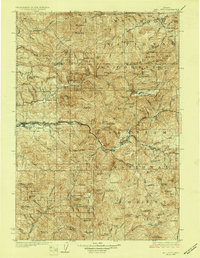
 1956 Detroit1958 Print · USGSThe Oregon Cascades transition into the reservoir era in the mid-1950s as the newly formed Detroit Reservoir reshapes the canyon. Trace the original footprints of Detroit and Idanha or locate early wilderness lookouts like those at Minniece Point and Coffin Mtn.2 unique versions available
 - 1960 Map of Salem, 1968 Print
 1960 Salem1968 Print · USGSThe Willamette Valley and the surrounding mountain ranges are shown here in the 1960s during a period of significant reservoir construction. Genealogists and historians can trace rail lines like the Oregon Electric and find communities from Lincoln City on the coast to Sweet Home and Mill City in the foothills.2 unique versions available
 - 1962 Map of Salem
 1962 Salem1962 Print · USGSThe Willamette Valley and the surrounding Oregon ranges are captured here in the early sixties, showing the vital growth of the state's primary agricultural and academic corridor. Researchers can trace the mid-century footprints of Oregon State University and the University of Oregon, alongside rural landmarks like Camp Adair and Black Butte Mine.
 - 1963 Map of Salem
 1963 Salem1963 Print · USGSMid-century Oregon comes into focus as the Willamette Valley’s timber and agricultural industries meet the growing campuses of Oregon State University and the University of Oregon. Researchers can trace old rail lines like the Oregon Electric Railway and locate family plots at Siletz Cem or Dallas Cem.
 - 1983 Map of North Santiam River, 1984 Print
 1983 North Santiam River1984 Print · USGSThe western Cascades and Willamette Valley transition in the early eighties, from the state capital to the high timberlands. Genealogists and historians can trace rail lines like the Southern Pacific and explore communities from Mill City to Silver Falls City.
 - 1985 Map of Idanha
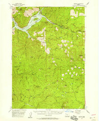
 1985 Idanha1985 Print · USGSThe mountain town of Idanha and the upper reaches of the Santiam canyon are captured here in the mid-1980s. Local researchers can trace old timber roads and find specific recreation sites like Hoover Campground, Bruno Meadows, and Whispering Falls Campground.
 - 1991 Map of North Santiam River, 1993 Print
 1991 North Santiam River1993 Print · USGSMarion and Linn counties come into focus in the early 1990s as the Santiam River valley transitions from the Willamette Valley floor to the Cascade peaks. Researchers can trace timber and rail history through Mill City, locate family landmarks near Stayton, or explore the boundaries of Silver Falls State Park.
 - 1994 Map of Idanha, 1998 Print
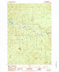
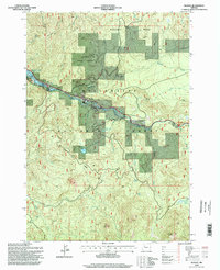 1994 Idanha1998 Print · USGSThe mountain settlement of Idanha and the upper reaches of Detroit Lake are captured here during the mid-1990s. Researchers can trace the river-valley economy through local landmarks like the Gaging Station, Whispering Falls, and the Santiam State Forest.
End of results
Showing maps 1-11 of 11
Frequently asked questions
- What are the different types of historical maps available for New Idanha?
- What is the oldest map of New Idanha?
- Where can I purchase historical maps of New Idanha for my home or office?
- Where can I download high-res historical maps of New Idanha?
- Are there historical topographic maps available for New Idanha?
- Is there historical aerial imagery available for New Idanha?
- Where are historical maps of New Idanha sourced from?