1900s (20th Century) Maps of West Salem, Salem
Explore 12 historic maps of West Salem from the 1900s (20th Century). These maps offer a rare glimpse into what life looked like during the 1900s — showing old roads, neighborhoods, homes, and landmarks that have changed or disappeared over time.
Whether you're researching your family's past, planning a metal detecting trip, or studying how West Salem's landscape evolved across the 1900s, these high-resolution maps are a powerful tool for exploring the history of this region.
- Focus on a specific era: All maps on this page are from the 1900s, giving you a focused view of this time period.
- See what’s changed: Compare century-old streets, trails, and buildings to today's modern landscape using overlays and satellite layers.
- Research with precision: Use these maps for genealogy, historical research, land use analysis, or educational projects.
- View, download, or print: Maps are fully viewable online in high resolution, and can be downloaded or printed for your own records.
Start exploring West Salem's history through authentic maps from the 1900s. This is your window into the past.
West Salem, Salem maps
(12)- 1915 Map of Eola
 1915 Eola1915 Print · USGSThe Willamette Valley at the start of the twentieth century reveals a landscape defined by the growth of Salem and its major state institutions. Researchers can trace early railroad lines like the Oregon Electric Railway and find vanished rural schools including Peanut School and Mountainview School.
 - 1917 Map of Salem
 1917 Salem1917 Print · USGSThe Willamette Valley at the peak of its rail-and-river era shows a landscape of growing towns and specialized state institutions. Researchers can trace early family-named junctions and rural educational sites like Grabenhorst Corners, Keizer School, and Wigrich Landing.3 unique versions available
 - 1940 Map of Salem
 1940 Salem1940 Print · USGSThe Willamette Valley thrives in the early days of the war, as Salem expands around its rail hubs and state institutions. Researchers can trace the legacy of the Southern Pacific line and find vanished local landmarks like the Poor Farm School for the Deaf or Oak Grove Church.
 - 1953 Map of Salem
 1953 Salem1953 Print · USGSMid-century Oregon comes to life through this detailed survey of the Willamette Valley and the adjacent Pacific coastline. Researchers can trace the rail lines of the Southern Pacific RR, visit rural hubs like Fairview School, or locate coastal landmarks like the Yaquina Head Lighthouse.
 - 1954 Map of Salem
 1954 Salem1954 Print · USGSMid-century Western Oregon is centered on the productive Willamette River valley as its cities and infrastructure expand toward the mountains. Genealogists and historians can trace the rail lines of the Southern Pacific RR and Oregon Electric Ry through towns like Dallas, Independence, and Brownsville.
 - 1957 Map of Salem, 1959 Print
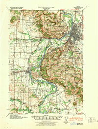
 1957 Salem1959 Print · USGSThe Willamette Valley thrives during the mid-fifties as the state capital expands across the river into West Salem. Genealogists can trace family names and landmarks through Eola Cem, Pioneer Cemetery, and the riverside rail stops of the Oregon Electric line.2 unique versions available
 - 1960 Map of Salem, 1968 Print
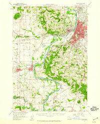
 1960 Salem1968 Print · USGSThe Willamette Valley and the surrounding mountain ranges are shown here in the 1960s during a period of significant reservoir construction. Genealogists and historians can trace rail lines like the Oregon Electric and find communities from Lincoln City on the coast to Sweet Home and Mill City in the foothills.2 unique versions available
 - 1962 Map of Salem
 1962 Salem1962 Print · USGSThe Willamette Valley and the surrounding Oregon ranges are captured here in the early sixties, showing the vital growth of the state's primary agricultural and academic corridor. Researchers can trace the mid-century footprints of Oregon State University and the University of Oregon, alongside rural landmarks like Camp Adair and Black Butte Mine.
 - 1963 Map of Salem
 1963 Salem1963 Print · USGSMid-century Oregon comes into focus as the Willamette Valley’s timber and agricultural industries meet the growing campuses of Oregon State University and the University of Oregon. Researchers can trace old rail lines like the Oregon Electric Railway and locate family plots at Siletz Cem or Dallas Cem.
 - 1969 Map of Salem West, 1972 Print
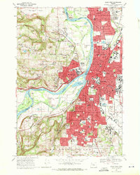 1969 Salem West1972 Print · USGSThe Salem area and the winding Willamette River are captured here during a period of significant growth in the late sixties. Researchers can trace the footprints of the State Capitol, the Oregon State Penitentiary, and historic grounds like Pioneer Cem and Willamette University.5 unique versions available
 - 1975 Map of Salem West, 1980 Print
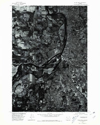 1975 Salem West1980 Print · USGSMid-century development and the winding river corridor define this 1975 aerial survey of the Marion County area. Local historians can trace the growth of Salem and the residential patterns of Liberty through these detailed orthophotograph images.
 - 1980 Map of Corvallis, 1981 Print
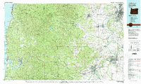 1980 Corvallis1981 Print · USGSThe Oregon Coast Range meets the fertile Willamette Valley in the early eighties, documenting a landscape of timber, agriculture, and growing college towns. Genealogists and historians can trace old rail lines like the Southern Pacific or locate landmarks like Marys Peak and the College of Education.
End of results
Showing maps 1-12 of 12
Frequently asked questions
- What are the different types of historical maps available for West Salem?
- What is the oldest map of West Salem?
- Where can I purchase historical maps of West Salem for my home or office?
- Where can I download high-res historical maps of West Salem?
- Are there historical topographic maps available for West Salem?
- Is there historical aerial imagery available for West Salem?
- Where are historical maps of West Salem sourced from?