Old Maps of Warrendale, Oregon
Explore 13 old maps of Warrendale, spanning from 1948 to today. These high-resolution historic maps reveal how streets, neighborhoods, landmarks, and natural features evolved over time — perfect for genealogy, metal detecting, research, and local history exploration.
What you can do with these maps:
- See how Warrendale changed over time: Compare historical maps to modern-day views to trace roads, homesites, rail lines & more.
- View detailed metadata: Each map includes creators, publishers, year, scale, and archive source.
- Overlay maps with satellite & LiDAR: Visualize the past alongside modern tools to explore terrain & human change.
- Trusted historical sources: Maps sourced from the USGS, Library of Congress, and other archives.
- Access maps your way: View online, download high-res files, or order prints for personal or research use.
Start exploring old maps of Warrendale to uncover forgotten places, hidden landmarks, and the deep history beneath your feet.
Warrendale, OR maps
(13)- 1948 Map of Vancouver, 1957 Print
 1948 Vancouver1957 Print · USGSPost-war growth transforms the river valleys of the Pacific Northwest as the timber and rail economy thrives. Trace family roots in Tillamook or Oregon City, and locate vanished landmarks like the spit at Bayocean or the Skamania Mine.
 - 1950 Map of Vancouver
 1950 Vancouver1950 Print · USGSCoastal Oregon and the lower Columbia River valley are captured in detail just after the war. Researchers can trace historic rail routes like the Southern Pacific or locate early settlements such as Vernonia, Gaston, and the Grand Ronde Indian Reservation.
 - 1950 Map of Vancouver, 1951 Print
 1950 Vancouver1951 Print · USGSThe Pacific Northwest urban corridor meets the rugged coast in the years following the war, showing the expansion of Portland and Vancouver. Genealogists and historians can trace the reach of the Southern Pacific RR and locate coastal communities like Tillamook, Seaside, and Tolovana Park.
 - 1954 Map of Bridal Veil, 1958 Print
 1954 Bridal Veil1958 Print · USGSThe Columbia River Gorge in the mid-1950s was a bustling corridor of rail lines and early highways. Genealogists and historians can trace the foundations of riverside communities like Bridal Veil and Dodson or locate industrial sites like the Skamania Mine.4 unique versions available
 - 1958 Map of Vancouver, 1968 Print
 1958 Vancouver1968 Print · USGSThe Lower Columbia and Willamette valleys thrive in the late sixties as major rail and river hubs. Genealogists and historians can trace the development of Portland, identify the grounds of Camp Withycombe, and locate coastal landmarks from Tillamook Head to Garibaldi.3 unique versions available
 - 1964 Map of Vancouver
 1964 Vancouver1964 Print · USGSThe Pacific Northwest interior and coast are shown here in the 1960s, from the Portland metropolitan hub to the rugged Pacific shoreline. Researchers can trace the legacy of the Grand Ronde Indian Reservation, the early layout of McMinnville, and the maritime approaches near Tillamook Head.
 - 1979 Map of Vancouver, 1980 Print
 1979 Vancouver1980 Print · USGSThe Portland and Vancouver metropolitan area is captured here in the late seventies, showing the dense nexus of river, rail, and air transit. Genealogists and local historians can trace the footprints of Vancouver Barracks, Lincoln Memorial Park Cem, and the old rail lines of the Burlington Northern.2 unique versions available
 - 1986 Map of Multnomah Falls
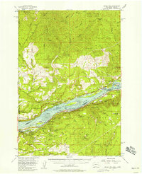
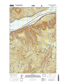
 1986 Multnomah Falls1986 Print · USGSThe Columbia River Gorge in the mid-eighties shows a landscape of dramatic cataracts and vital transit routes. Trace the historic paths between Skamania Landing and Warrendale, or locate landmarks like Multnomah Falls and the towering Saint Peters Dome.2 unique versions available
 - 1994 Map of Multnomah Falls, 1997 Print
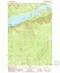
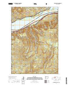
 1994 Multnomah Falls1997 Print · USGSThe Columbia River Gorge in the 1990s shows a landscape of protected wilderness and iconic waterfalls. Researchers can trace the riverfront settlements of Warrendale and Dodson or locate landmarks like Larch Mtn and Saint Peters Dome.
 - 2014 Map of Multnomah Falls, 2014 Print
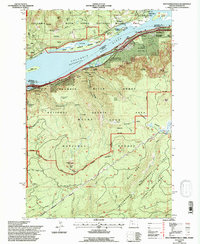
 2014 Multnomah Falls2014 Print · USGSCovers Warrendale, including Dodson, Multnomah County, and other nearby areas
 - 2017 Map of Multnomah Falls, 2017 Print
 2017 Multnomah Falls2017 Print · USGSCovers Warrendale, including Dodson, Multnomah County, and other nearby areas
 - 2020 Map of Multnomah Falls, 2020 Print
 2020 Multnomah Falls2020 Print · USGSCovers Warrendale, including Dodson, Multnomah County, and other nearby areas
 - 2024 Map of Multnomah Falls, 2024 Print
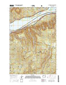
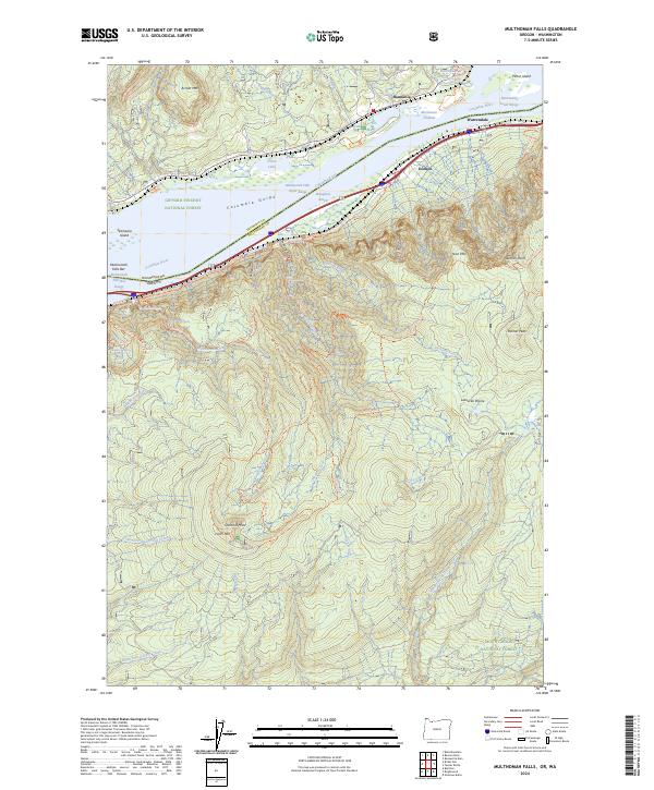 2024 Multnomah Falls2024 Print · USGSThe Columbia River Gorge at the start of the 2020s remains a landscape of dramatic elevation and protected wilderness. Hikers and historians can trace the paths to Multnomah Falls, Oneonta Gorge, and the high peak of Larch Mtn.
End of results
Showing maps 1-13 of 13
Top cities near Warrendale
- Sandy historical maps
- Carson historical maps
- Stevenson historical maps
- Cascade Locks historical maps
- North Bonneville historical maps
Frequently asked questions
- What are the different types of historical maps available for Warrendale?
- What is the oldest map of Warrendale?
- Where can I purchase historical maps of Warrendale for my home or office?
- Where can I download high-res historical maps of Warrendale?
- Are there historical topographic maps available for Warrendale?
- Is there historical aerial imagery available for Warrendale?
- Where are historical maps of Warrendale sourced from?