Old Maps of Neskowin, Oregon for Hiking & Exploration
Hike through history with 20 historic maps of Neskowin. Explore old trails, ghost towns, and forgotten backroads — perfect for outdoor adventurers and local explorers.
- Rediscover forgotten places: Map out old mining camps, roads, and footpaths that no longer exist on modern maps.
- Layer with modern tools: Combine with LiDAR or satellite views to plan hikes through historical terrain.
- Made for exploration: Popular among hikers, overlanders, and local history lovers.
Use these maps to find adventure and explore the hidden past of Neskowin.
Neskowin, OR maps
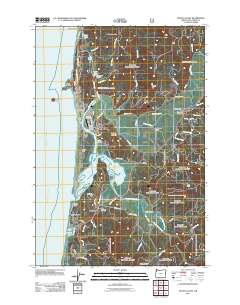
(20)- 1941 Map of Nestucca Bay
 1941 Nestucca Bay1941 Print · USGSThe Oregon coast at the start of the 1940s reveals a mix of timber industry and early seaside tourism. Trace the history of coastal work and recreation through labels like the Miles Lake CCC Camp, Hebo Alder Mill, and the many fire lookouts.
 - 1942 Map of Nestucca Bay
 1942 Nestucca Bay1942 Print · USGSCoastal Oregon is captured here during the early war years as timber and forest management shaped the local economy. Researchers can locate vanished infrastructure like the Hebohalder Mill and Powder House, or trace the development of Pacific City and Neskowin.
 - 1948 Map of Vancouver, 1957 Print
 1948 Vancouver1957 Print · USGSPost-war growth transforms the river valleys of the Pacific Northwest as the timber and rail economy thrives. Trace family roots in Tillamook or Oregon City, and locate vanished landmarks like the spit at Bayocean or the Skamania Mine.
 - 1950 Map of Vancouver
 1950 Vancouver1950 Print · USGSCoastal Oregon and the lower Columbia River valley are captured in detail just after the war. Researchers can trace historic rail routes like the Southern Pacific or locate early settlements such as Vernonia, Gaston, and the Grand Ronde Indian Reservation.
 - 1950 Map of Vancouver, 1951 Print
 1950 Vancouver1951 Print · USGSThe Pacific Northwest urban corridor meets the rugged coast in the years following the war, showing the expansion of Portland and Vancouver. Genealogists and historians can trace the reach of the Southern Pacific RR and locate coastal communities like Tillamook, Seaside, and Tolovana Park.
 - 1955 Map of Hebo, 1957 Print
 1955 Hebo1957 Print · USGSCoastal Tillamook County is captured here in the mid-fifties, showing the development of beach communities and forest management. Genealogists can trace family sites like Herbst Place or locate the Town Lake Cemetery and Cloverdale School.3 unique versions available
 - 1958 Map of Vancouver, 1968 Print
 1958 Vancouver1968 Print · USGSThe Lower Columbia and Willamette valleys thrive in the late sixties as major rail and river hubs. Genealogists and historians can trace the development of Portland, identify the grounds of Camp Withycombe, and locate coastal landmarks from Tillamook Head to Garibaldi.3 unique versions available
 - 1964 Map of Vancouver
 1964 Vancouver1964 Print · USGSThe Pacific Northwest interior and coast are shown here in the 1960s, from the Portland metropolitan hub to the rugged Pacific shoreline. Researchers can trace the legacy of the Grand Ronde Indian Reservation, the early layout of McMinnville, and the maritime approaches near Tillamook Head.
 - 1980 Map of Yamhill River
 1980 Yamhill River1980 Print · USGSThe Oregon Coast Range and the western Willamette Valley meet in this 1980 survey, showing the landscape from the Pacific shore to the valley floor. Genealogists and historians can trace old routes like the Salmon River Highway to find the Grand Ronde Agency, Cloverdale, and Perrydale.3 unique versions available
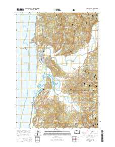
 - 1985 Map of Neskowin
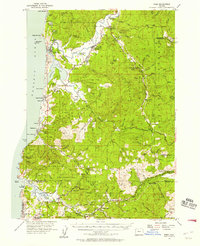
 1985 Neskowin1985 Print · USGSThe Oregon coast at the mid-eighties reveals a landscape of protected forests and quiet seaside communities along the Salmon River. Genealogists and local historians can trace the early layout of Neskowin, Otis, and Rose Lodge amid the Siuslaw National Forest.2 unique versions available
 - 1985 Map of Nestucca Bay, 1986 Print
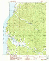
 1985 Nestucca Bay1986 Print · USGSThe Tillamook coast in the mid-1980s reveals a landscape of tidal estuaries and timbered ridges where the river meets the sea. Researchers can trace family history through the Cem near Cloverdale or locate old coastal landmarks like Fisher Landing and Oretown.
 - 2011 Map of Neskowin, 2011 Print
 2011 Neskowin2011 Print · USGSCovers Neskowin, including Lincoln City, Otis, and other nearby areas
 - 2011 Map of Nestucca Bay, 2011 Print
 2011 Nestucca Bay2011 Print · USGSCovers Neskowin, including Woods, Cloverdale, and other nearby areas
 - 2014 Map of Nestucca Bay, 2014 Print
 2014 Nestucca Bay2014 Print · USGSCovers Neskowin, including Woods, Cloverdale, and other nearby areas
 - 2014 Map of Neskowin, 2014 Print
 2014 Neskowin2014 Print · USGSCovers Neskowin, including Lincoln City, Otis, and other nearby areas
 - 2017 Map of Neskowin, 2017 Print
 2017 Neskowin2017 Print · USGSCovers Neskowin, including Lincoln City, Otis, and other nearby areas
 - 2020 Map of Nestucca Bay, 2020 Print
 2020 Nestucca Bay2020 Print · USGSCovers Neskowin, including Woods, Cloverdale, and other nearby areas
 - 2020 Map of Neskowin, 2020 Print
 2020 Neskowin2020 Print · USGSCovers Neskowin, including Lincoln City, Otis, and other nearby areas
 - 2024 Map of Nestucca Bay, 2024 Print
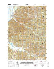
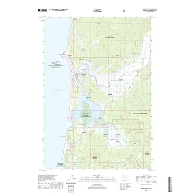
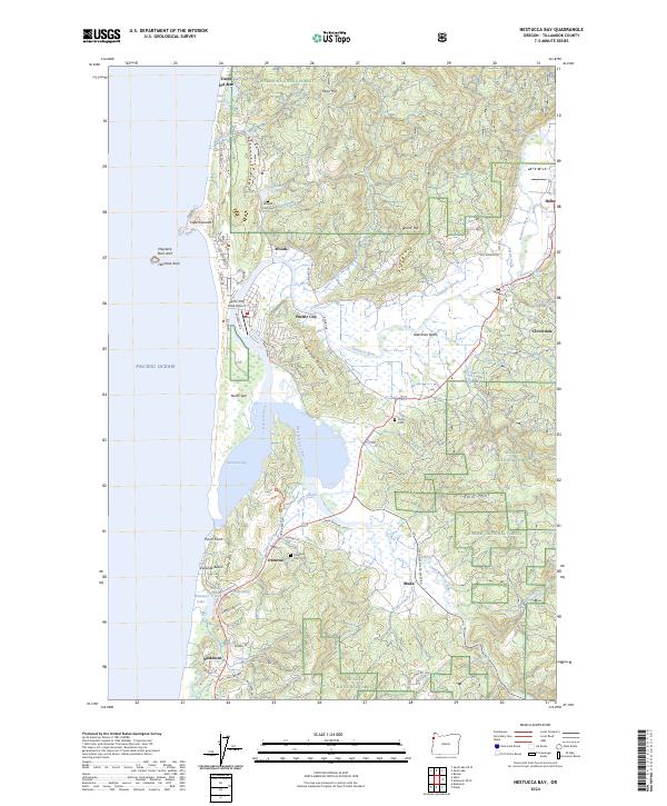 2024 Nestucca Bay2024 Print · USGSThe Tillamook County coastline appears in high detail in this modern survey of the Nestucca Bay estuary. Researchers can trace family history at the Oretown Cem or explore the coastal layout of Pacific City and Neskowin.
 - 2024 Map of Neskowin, 2024 Print
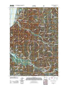
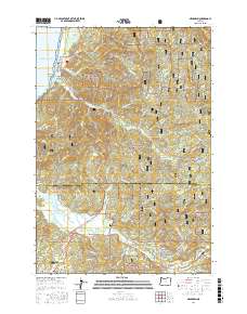
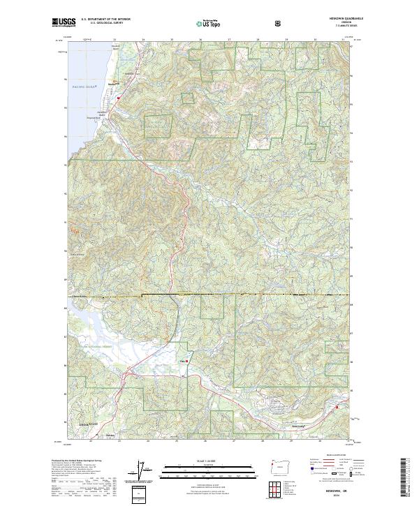 2024 Neskowin2024 Print · USGSThe Oregon coast near the Tillamook and Lincoln county line comes alive in this survey of beach settlements and river valleys. Researchers can trace the development of Neskowin and Rose Lodge or find coastal landmarks like Proposal Rock.
End of results
Showing maps 1-20 of 20
Top cities near Neskowin
Top neighborhoods of Neskowin
Frequently asked questions
- What are the different types of historical maps available for Neskowin?
- What is the oldest map of Neskowin?
- Where can I purchase historical maps of Neskowin for my home or office?
- Where can I download high-res historical maps of Neskowin?
- Are there historical topographic maps available for Neskowin?
- Is there historical aerial imagery available for Neskowin?
- Where are historical maps of Neskowin sourced from?