1960s Maps of Umatilla, Oregon
Explore 2 historic maps of Umatilla from the 1960s. These maps offer a rare glimpse into what life looked like during the 1960s — showing old roads, neighborhoods, homes, and landmarks that have changed or disappeared over time.
Whether you're researching your family's past, planning a metal detecting trip, or studying how Umatilla's landscape evolved across the 1960s, these high-resolution maps are a powerful tool for exploring the history of this region.
- Focus on a specific era: All maps on this page are from the 1960s, giving you a focused view of this time period.
- See what’s changed: Compare century-old streets, trails, and buildings to today's modern landscape using overlays and satellite layers.
- Research with precision: Use these maps for genealogy, historical research, land use analysis, or educational projects.
- View, download, or print: Maps are fully viewable online in high resolution, and can be downloaded or printed for your own records.
Start exploring Umatilla's history through authentic maps from the 1960s. This is your window into the past.
Umatilla, OR maps
(2)- 1962 Map of Hat Rock, 1963 Print
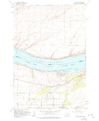 1962 Hat Rock1963 Print · USGSThe Columbia River shoreline in the early sixties reveals a landscape of massive water projects and rail infrastructure. Trace the river's edge through Berrian or explore the landmarks of Hat Rock State Park and the Cold Springs National Wildlife Refuge.3 unique versions available
 - 1962 Map of Umatilla, 1963 Print
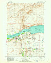 1962 Umatilla1963 Print · USGSThe Columbia River frontier underwent massive change in the early sixties as hydroelectric power reshaped the landscape. Researchers can trace the mid-century growth of Umatilla and Power City alongside the sprawling infrastructure of McNary Dam.4 unique versions available
End of results
Showing maps 1-2 of 2
Top cities near Umatilla
Top neighborhoods of Umatilla
Frequently asked questions
- What are the different types of historical maps available for Umatilla?
- What is the oldest map of Umatilla?
- Where can I purchase historical maps of Umatilla for my home or office?
- Where can I download high-res historical maps of Umatilla?
- Are there historical topographic maps available for Umatilla?
- Is there historical aerial imagery available for Umatilla?
- Where are historical maps of Umatilla sourced from?