1970s Maps of Chenowith, Oregon
Explore 2 historic maps of Chenowith from the 1970s. These maps offer a rare glimpse into what life looked like during the 1970s — showing old roads, neighborhoods, homes, and landmarks that have changed or disappeared over time.
Whether you're researching your family's past, planning a metal detecting trip, or studying how Chenowith's landscape evolved across the 1970s, these high-resolution maps are a powerful tool for exploring the history of this region.
- Focus on a specific era: All maps on this page are from the 1970s, giving you a focused view of this time period.
- See what’s changed: Compare century-old streets, trails, and buildings to today's modern landscape using overlays and satellite layers.
- Research with precision: Use these maps for genealogy, historical research, land use analysis, or educational projects.
- View, download, or print: Maps are fully viewable online in high resolution, and can be downloaded or printed for your own records.
Start exploring Chenowith's history through authentic maps from the 1970s. This is your window into the past.
Chenowith, OR maps
(2)- 1974 Map of The Dalles North, 1977 Print
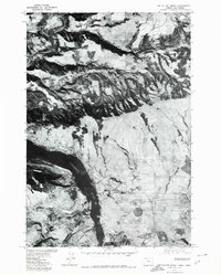
 1974 The Dalles North1977 Print · USGSThe Columbia River Gorge in the mid-seventies reveals a thriving intersection of rail, river, and regional industry. Researchers can trace the layout of The Dalles and Smithville or locate family sites at Wish-Ham Cem and the Chenoweth Sch.2 unique versions available
 - 1975 Map of The Dalles North, 1980 Print
 1975 The Dalles North1980 Print · USGSAlong the Columbia River in the mid-1970s, this aerial perspective captures the landscape of the Oregon and Washington border. Researchers can trace the development of river-side settlements like Murdock and Smithville while observing the winding course of the Klickitat River.
End of results
Showing maps 1-2 of 2
Top cities near Chenowith
- The Dalles historical maps
- White Salmon historical maps
- Bingen historical maps
- Dufur historical maps
- Mosier historical maps
Frequently asked questions
- What are the different types of historical maps available for Chenowith?
- What is the oldest map of Chenowith?
- Where can I purchase historical maps of Chenowith for my home or office?
- Where can I download high-res historical maps of Chenowith?
- Are there historical topographic maps available for Chenowith?
- Is there historical aerial imagery available for Chenowith?
- Where are historical maps of Chenowith sourced from?