
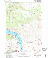
1974 Map of The Dalles North
USGS Topo · Published 1977About this map
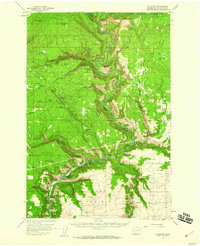
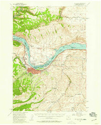
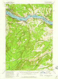
The Columbia River forms the central artery of this mid-1970s survey, marking the border between Washington and Oregon as it flows through the Gap. The landscape is a study in transport and infrastructure, where the Union Pacific and Burlington Northern railroads parallel the water on opposite banks. To the south, the city of The Dalles exhibits its mid-century footprint, including The Dalles HS, the Drive-in Theater, and residential areas near Chenoweth Creek. Across the river in Washington, the terrain rises into the Columbia Hills and the expansive High Prairie. Notable landmarks such as The Dalles Municipal Airport and the riverside Murdock settlement emphasize the area's role as a regional hub. Local history is preserved in sites like Hartland Cem and Wish-Ham Cem, while Mayer State Park occupies a prominent stretch of the Oregon shoreline.
Find a feature on this map
69 named features on this map. Tap any name to fly to it.
Don’t see what you’re looking for? This feature index may not catch every label — zoom into the map to look around manually.
Map Details
Editions of this 1974 The Dalles North Map
2 editions found
Other maps of this area

1934 · The Dalles
USGS Topo · 1:125,000

1953 · The Dalles
USGS Topo · 1:250,000

1956 · The Dalles
USGS Topo · 1:250,000

1957 · The Dalles
USGS Topo · 1:250,000
1957 · Klickitat
USGS Topo · 1:62,500
1957 · The Dalles
USGS Topo · 1:62,500
1957 · White Salmon
USGS Topo · 1:62,500
1957 · Husum
USGS Topo · 1:62,500
1974 · Stacker Butte
USGS Topo · 1:24,000
1974 · Brown Creek
USGS Topo · 1:24,000