
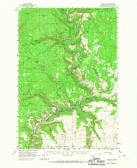
1957 Map of Klickitat
USGS Topo · Published 1959About this map
Klickitat sits at the base of dramatic canyon walls where the river makes a sharp westward bend, serving as a hub for both logging and rail transport in the mid-1950s. The Spokane Portland and Seattle Railroad follows the water closely, threading through the landscape alongside a network of Private Logging Roads that reach into the surrounding highlands. This map documents a specialized industry-driven landscape, from the Woodruff Mill in the central canyon to the Gravel Pit near Wahiacus. On the higher elevations, the Yakima Indian Reservation boundary crosses Grayback Mtn, while the open spaces of High Prairie and Crofton Prairie provide a stark contrast to the deep incisions of Dead Canyon and Snyder Canyon. Local heritage is marked by several remote sites, including the small Cem near Klickitat and established camps like Raiders Camp and Klott Camp.
Find a feature on this map
57 named features on this map. Tap any name to fly to it.
Don’t see what you’re looking for? This feature index may not catch every label — zoom into the map to look around manually.
Map Details
Editions of this 1957 Klickitat Map
2 editions found
Other maps of this area

1904 · Mount Adams
USGS Topo · 1:125,000

1907 · Mount Adams
USGS Topo · 1:125,000

1934 · The Dalles
USGS Topo · 1:125,000

1937 · White Swan
USGS Topo · 1:125,000

1950 · Yakima
USGS Topo · 1:250,000

1953 · The Dalles
USGS Topo · 1:250,000

1956 · The Dalles
USGS Topo · 1:250,000

1957 · The Dalles
USGS Topo · 1:250,000

1957 · Goldendale
USGS Topo · 1:62,500

1957 · The Dalles
USGS Topo · 1:62,500