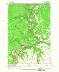
1957 Map of Klickitat
USGS Topo · Published 1967About this map
The Klickitat River carves a deep path through this 1957 survey of Klickitat County, serving as the industrial and logistical spine for the region's timber operations. The town of Klickitat sits at the center of this activity, supported by the Klickitat Logging Railroad and the Spokane Portland and Seattle line. These rail networks reflect an era when heavy industry moved through the canyons, connecting mills like Woodruff Mill to wider markets. North of the river, the landscape rises into the Yakima Indian Reservation and the slopes of Grayback Mtn.
Find a feature on this map
62 named features on this map. Tap any name to fly to it.
Don’t see what you’re looking for? This feature index may not catch every label — zoom into the map to look around manually.
Map Details
Editions of this 1957 Klickitat Map
2 editions found
Other maps of this area

1904 · Mount Adams
USGS Topo · 1:125,000

1907 · Mount Adams
USGS Topo · 1:125,000

1934 · The Dalles
USGS Topo · 1:125,000

1937 · White Swan
USGS Topo · 1:125,000

1950 · Yakima
USGS Topo · 1:250,000

1953 · The Dalles
USGS Topo · 1:250,000

1956 · The Dalles
USGS Topo · 1:250,000

1957 · The Dalles
USGS Topo · 1:250,000

1957 · Klickitat
USGS Topo · 1:62,500

1957 · Goldendale
USGS Topo · 1:62,500