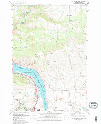
1974 Map of The Dalles North
USGS Topo · Published 1977About this map
The Columbia River serves as the focal point of this mid-1970s survey, marking the state boundary between Oregon and Washington. This reach of the river includes the distinctive Rowena Gap and Crates Point, with the water level regulated at the Bonneville Normal Pool Elevation 72. Transport and industry define the corridor, where the Union Pacific and Burlington Northern railroads parallel the banks. To the north, the terrain rises into the Columbia Hills, characterized by numerous drainages like Dillacort Canyon and Knight Canyon. The settlement of The Dalles is visible at the southern edge, supported by local infrastructure including the Chenoweth Sch and The Dalles Municipal Airport. Smaller communities such as Murdock and Smithville sit on the Washington side, while Mayer State Park provides recreation along the Oregon shore.
Find a feature on this map
48 named features on this map. Tap any name to fly to it.
Don’t see what you’re looking for? This feature index may not catch every label — zoom into the map to look around manually.
Map Details
Editions of this 1974 The Dalles North Map
2 editions found
Other maps of this area

1934 · The Dalles
USGS Topo · 1:125,000

1953 · The Dalles
USGS Topo · 1:250,000

1956 · The Dalles
USGS Topo · 1:250,000

1957 · The Dalles
USGS Topo · 1:250,000

1957 · Klickitat
USGS Topo · 1:62,500

1957 · The Dalles
USGS Topo · 1:62,500

1957 · White Salmon
USGS Topo · 1:62,500

1957 · Husum
USGS Topo · 1:62,500

1974 · Stacker Butte
USGS Topo · 1:24,000

1974 · The Dalles North
USGS Topo · 1:24,000