1970s Maps of Cherry Heights, Wasco County
Explore 2 historic maps of Cherry Heights from the 1970s. These maps offer a rare glimpse into what life looked like during the 1970s — showing old roads, neighborhoods, homes, and landmarks that have changed or disappeared over time.
Whether you're researching your family's past, planning a metal detecting trip, or studying how Cherry Heights's landscape evolved across the 1970s, these high-resolution maps are a powerful tool for exploring the history of this region.
- Focus on a specific era: All maps on this page are from the 1970s, giving you a focused view of this time period.
- See what’s changed: Compare century-old streets, trails, and buildings to today's modern landscape using overlays and satellite layers.
- Research with precision: Use these maps for genealogy, historical research, land use analysis, or educational projects.
- View, download, or print: Maps are fully viewable online in high resolution, and can be downloaded or printed for your own records.
Start exploring Cherry Heights's history through authentic maps from the 1970s. This is your window into the past.
Cherry Heights, Wasco County maps
(2)- 1975 Map of The Dalles South, 1980 Print
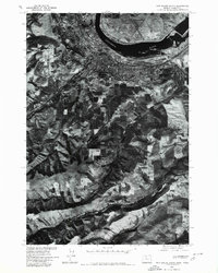 1975 The Dalles South1980 Print · USGSThe Dalles and its surrounding plateaus appear in sharp detail during the mid-1970s in this orthophotographic survey. Genealogists and local historians can trace the riverside development of The Dalles and the rural agricultural patterns along Fivemile Creek.
 - 1977 Map of The Dalles South, 1978 Print
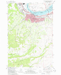 1977 The Dalles South1978 Print · USGSThe mid-Columbia River shoreline comes alive in the late seventies, showing the vital link between the river and the rail-driven economy. Trace the legacy of early residents at Pioneer Cem or GAR Cem and explore the irrigation and elevation changes near Cherry Heights.2 unique versions available
End of results
Showing maps 1-2 of 2
Frequently asked questions
- What are the different types of historical maps available for Cherry Heights?
- What is the oldest map of Cherry Heights?
- Where can I purchase historical maps of Cherry Heights for my home or office?
- Where can I download high-res historical maps of Cherry Heights?
- Are there historical topographic maps available for Cherry Heights?
- Is there historical aerial imagery available for Cherry Heights?
- Where are historical maps of Cherry Heights sourced from?