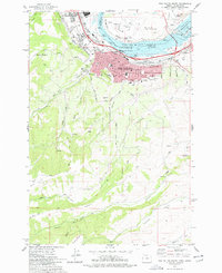
1977 Map of The Dalles South
USGS Topo · Published 1978About this map
The industrial and civic heart of the mid-Columbia River region is documented here in the mid-1970s, focused on The Dalles. This survey captures the complex infrastructure of the The Dalles Dam and Lake Celilo as they appeared just before the close of the decade. The landscape transition from the riverfront Port of The Dalles and Union Pacific rail lines to the high-elevation orchards of Cherry Heights is clearly visible. For genealogists and local historians, the map provides precise locations for the Pioneer Cem, IOOF Cem, GAR Cem, and Masonic Cem. To the south, the terrain opens into broad agricultural plateaus like Dutch Flat and Mt Hood Flat, while the northern banks of the river show the The Dalles Municipal Airport and the settlement of Dallesport in Klickitat County, Washington.
Find a feature on this map
39 named features on this map. Tap any name to fly to it.
Don’t see what you’re looking for? This feature index may not catch every label — zoom into the map to look around manually.
Map Details
Editions of this 1977 The Dalles South Map
2 editions found
Other maps of this area

1930 · Dufur
USGS Topo · 1:125,000

1934 · Dufur
USGS Topo · 1:125,000

1934 · The Dalles
USGS Topo · 1:125,000

1953 · The Dalles
USGS Topo · 1:250,000

1956 · The Dalles
USGS Topo · 1:250,000

1957 · The Dalles
USGS Topo · 1:250,000

1957 · The Dalles
USGS Topo · 1:62,500

1957 · White Salmon
USGS Topo · 1:62,500

1962 · Wolf Run
USGS Topo · 1:24,000

1962 · Dufur East
USGS Topo · 1:24,000