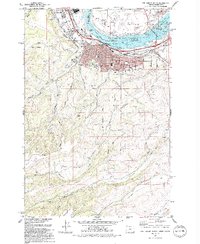
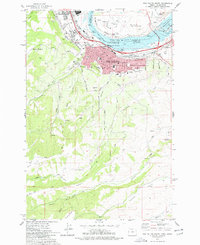
1977 Map of The Dalles South
USGS Topo · Published 1994About this map
The Dalles serves as the focal point of this mid-1970s survey, situated along the southern bank of the Columbia River where industry and history converge. The map documents the city's complex infrastructure, including the massive The Dalles Dam and the Port of The Dalles, which define the riverfront economy of this era. Across the water in Washington, Dallesport and the The Dalles Municipal Airport sit near Lake Celilo, the reservoir formed by the dam's construction. Moving south from the urban center, the landscape rises into agricultural heights and dissected plateau country, marked by series of numbered drainages such as Threemile Creek and Fivemile Creek. This period of the city's growth is captured through detailed residential expansions like Cherry Heights and the preservation of heritage at the Pioneer Cem, Ioof Cem, and Masonic Cem.
Find a feature on this map
39 named features on this map. Tap any name to fly to it.
Don’t see what you’re looking for? This feature index may not catch every label — zoom into the map to look around manually.
Map Details
Editions of this 1977 The Dalles South Map
2 editions found
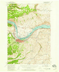
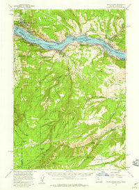
Other maps of this area

1930 · Dufur
USGS Topo · 1:125,000

1934 · Dufur
USGS Topo · 1:125,000

1934 · The Dalles
USGS Topo · 1:125,000

1953 · The Dalles
USGS Topo · 1:250,000

1956 · The Dalles
USGS Topo · 1:250,000

1957 · The Dalles
USGS Topo · 1:250,000
1957 · The Dalles
USGS Topo · 1:62,500
1957 · White Salmon
USGS Topo · 1:62,500
1962 · Wolf Run
USGS Topo · 1:24,000
1962 · Dufur East
USGS Topo · 1:24,000