
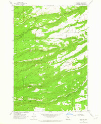
1962 Map of Wolf Run
USGS Topo · Published 1963About this map
The Mt Hood National Forest dominates this 1962 terrain, where the high ridges and deep drainages of Wasco County are marked by a network of historic transit routes and small-scale infrastructure. The presence of the Wolf Run Community Hall and the Dufur City Reservoir suggests a localized social and utility hub serving the surrounding rural landscape. This area is defined by its dramatic topographic relief, including Japanese Hollow and Hessian Canyon, which channel the flow of numerous waterways like Eightmile Creek and Fifteenmile Creek. Early industry and settlement patterns are evidenced by names like Dufur Mill Road and Ward Mill Road, indicating the movement of timber or grain through these high-elevation corridors. A distinct Jeep Trail and the Skyline Road traverse the ridges, mapping a landscape that remained focused on resource management and community navigation in the early 1960s.
Find a feature on this map
32 named features on this map. Tap any name to fly to it.
Don’t see what you’re looking for? This feature index may not catch every label — zoom into the map to look around manually.
Map Details
Editions of this 1962 Wolf Run Map
2 editions found
Other maps of this area

1930 · Dufur
USGS Topo · 1:125,000

1934 · Dufur
USGS Topo · 1:125,000

1934 · The Dalles
USGS Topo · 1:125,000

1953 · The Dalles
USGS Topo · 1:250,000

1956 · The Dalles
USGS Topo · 1:250,000

1957 · The Dalles
USGS Topo · 1:250,000

1957 · The Dalles
USGS Topo · 1:62,500

1957 · White Salmon
USGS Topo · 1:62,500

1962 · Postage Stamp Butte
USGS Topo · 1:24,000
1962 · Fivemile Butte
USGS Topo · 1:24,000