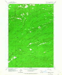
1962 Map of Fivemile Butte
USGS Topo · Published 1964About this map
Mt Hood National Forest dominates this topographic study of the eastern Cascades, tracing the complex drainage basins of Mill Creek, Fivemile Creek, and Eightmile Creek as they flow toward the Deschutes River valley. The landscape is defined by its forestry and transportation history, featuring a dense network of specialized routes including the Hollow Rail Road, Dufur Mill Road, and the Old Mail Road. These paths reveal a working landscape of timber extraction and mountain transit that once connected the high country to the lower plains.
Find a feature on this map
50 named features on this map. Tap any name to fly to it.
Don’t see what you’re looking for? This feature index may not catch every label — zoom into the map to look around manually.
Map Details
Editions of this 1962 Fivemile Butte Map
This is the sole edition of this map. No revisions or reprints were ever made.
Other maps of this area

1924 · Mount Hood
USGS Topo · 1:125,000

1926 · Hood River
USGS Topo · 1:125,000

1927 · Mount Hood
USGS Topo · 1:125,000

1929 · Hood River
USGS Topo · 1:125,000

1930 · Dufur
USGS Topo · 1:125,000

1934 · Dufur
USGS Topo · 1:125,000

1934 · The Dalles
USGS Topo · 1:125,000

1953 · The Dalles
USGS Topo · 1:250,000

1956 · The Dalles
USGS Topo · 1:250,000

1957 · The Dalles
USGS Topo · 1:250,000