1960s Maps of Dufur, Oregon
Explore 2 historic maps of Dufur from the 1960s. These maps offer a rare glimpse into what life looked like during the 1960s — showing old roads, neighborhoods, homes, and landmarks that have changed or disappeared over time.
Whether you're researching your family's past, planning a metal detecting trip, or studying how Dufur's landscape evolved across the 1960s, these high-resolution maps are a powerful tool for exploring the history of this region.
- Focus on a specific era: All maps on this page are from the 1960s, giving you a focused view of this time period.
- See what’s changed: Compare century-old streets, trails, and buildings to today's modern landscape using overlays and satellite layers.
- Research with precision: Use these maps for genealogy, historical research, land use analysis, or educational projects.
- View, download, or print: Maps are fully viewable online in high resolution, and can be downloaded or printed for your own records.
Start exploring Dufur's history through authentic maps from the 1960s. This is your window into the past.
Dufur, OR maps
(2)- 1962 Map of Dufur East, 1964 Print
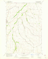 1962 Dufur East1964 Print · USGSDufur and the surrounding Wasco County canyons are captured in the early sixties as they balanced high-desert agriculture with established township life. Genealogists and local historians can trace family locations near the IOOF Cem, the Nansene Community Hall, and the small settlement of Boyd.2 unique versions available
 - 1962 Map of Dufur West, 1964 Print
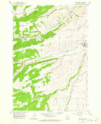 1962 Dufur West1964 Print · USGSDufur and the Wasco County uplands are captured in the early sixties as a thriving network of mills and high-country farms. Genealogists and local historians can trace family-named landmarks such as the Henderson Pioneer Cem, Ramsey Hall, and Endersby.3 unique versions available
End of results
Showing maps 1-2 of 2
Top cities near Dufur
Frequently asked questions
- What are the different types of historical maps available for Dufur?
- What is the oldest map of Dufur?
- Where can I purchase historical maps of Dufur for my home or office?
- Where can I download high-res historical maps of Dufur?
- Are there historical topographic maps available for Dufur?
- Is there historical aerial imagery available for Dufur?
- Where are historical maps of Dufur sourced from?