1900s (20th Century) Maps of Mitchell, Oregon
Explore 8 historic maps of Mitchell from the 1900s (20th Century). These maps offer a rare glimpse into what life looked like during the 1900s — showing old roads, neighborhoods, homes, and landmarks that have changed or disappeared over time.
Whether you're researching your family's past, planning a metal detecting trip, or studying how Mitchell's landscape evolved across the 1900s, these high-resolution maps are a powerful tool for exploring the history of this region.
- Focus on a specific era: All maps on this page are from the 1900s, giving you a focused view of this time period.
- See what’s changed: Compare century-old streets, trails, and buildings to today's modern landscape using overlays and satellite layers.
- Research with precision: Use these maps for genealogy, historical research, land use analysis, or educational projects.
- View, download, or print: Maps are fully viewable online in high resolution, and can be downloaded or printed for your own records.
Start exploring Mitchell's history through authentic maps from the 1900s. This is your window into the past.
Mitchell, OR maps
(8)- 1926 Map of Mitchell
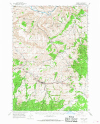
 1926 Mitchell1926 Print · USGSCentral Oregon ranching and geology are documented here in the mid-1920s, showing a landscape defined by the winding John River. Genealogists can locate family holdings like Old Frizzell Ranch and Laird Ranch alongside remote schoolhouses like Gable School.3 unique versions available
 - 1955 Map of Bend, 1964 Print
 1955 Bend1964 Print · USGSCentral Oregon was undergoing significant growth in the mid-1960s as irrigation and infrastructure transformed the high desert. Researchers can trace the path of the Oregon Trunk Line, locate old stops like Gateway, and find landmarks like Lava Butte or the Grange.3 unique versions available
 - 1957 Map of Bend
 1957 Bend1957 Print · USGSCentral Oregon in the mid-fifties is a landscape of transition between the high Cascades and the arid volcanic plateau. Local historians can trace the rail corridors of the Oregon Trunk and locate early settlements like Ashwood, Odin Falls, and Camp Sherman.
 - 1958 Map of Bend
 1958 Bend1958 Print · USGSCentral Oregon in the late fifties was a land of high desert ranching and growing mountain towns. Researchers can trace the rail lines of the Oregon Trunk Railroad, find established settlements like Madras and Sisters, or locate landmarks such as Smith Rock and Lava Butte.
 - 1966 Map of Mitchell, 1968 Print
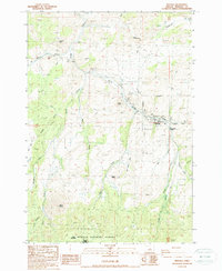
 1966 Mitchell1968 Print · USGSMitchell and the high desert of Central Oregon are captured here in the late sixties, showcasing a landscape of high buttes and isolated ranchlands. Genealogists can trace family footprints at Richmond Cemetery, the Gable Creek School, and the Old Frizzell Ranch.2 unique versions available
 - 1981 Map of Stephenson Mountain, 1997 Print
 1981 Stephenson Mountain1997 Print · USGSThe high-desert ranching and mining heart of North Central Oregon is captured here in the early eighties. Genealogists and historians can trace old settlements and mineral prospects from Shaniko to the Oregon King Mine and the John Day River canyon.
 - 1988 Map of Mitchell
 1988 Mitchell1988 Print · USGSCentral Oregon ranching and wilderness come into focus in the late 1980s around the town of Mitchell. Researchers can trace local landmarks like the Cem, the Mitchell Reservoir, and land holdings near Sargent Butte and Meyers.
 - 1992 Map of Mitchell, 1997 Print
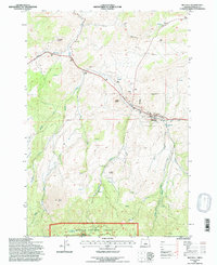 1992 Mitchell1997 Print · USGSMitchell sits at the confluence of rugged canyon streams in central Oregon during the early nineties. Researchers can trace the town's footprint near the Cem and Covered Reservoir, or explore the limits of the Ochoco National Forest.
End of results
Showing maps 1-8 of 8
Frequently asked questions
- What are the different types of historical maps available for Mitchell?
- What is the oldest map of Mitchell?
- Where can I purchase historical maps of Mitchell for my home or office?
- Where can I download high-res historical maps of Mitchell?
- Are there historical topographic maps available for Mitchell?
- Is there historical aerial imagery available for Mitchell?
- Where are historical maps of Mitchell sourced from?