1940s Maps of Menallen Township, Pennsylvania
Explore 7 historic maps of Menallen Township from the 1940s. These maps offer a rare glimpse into what life looked like during the 1940s — showing old roads, neighborhoods, homes, and landmarks that have changed or disappeared over time.
Whether you're researching your family's past, planning a metal detecting trip, or studying how Menallen Township's landscape evolved across the 1940s, these high-resolution maps are a powerful tool for exploring the history of this region.
- Focus on a specific era: All maps on this page are from the 1940s, giving you a focused view of this time period.
- See what’s changed: Compare century-old streets, trails, and buildings to today's modern landscape using overlays and satellite layers.
- Research with precision: Use these maps for genealogy, historical research, land use analysis, or educational projects.
- View, download, or print: Maps are fully viewable online in high resolution, and can be downloaded or printed for your own records.
Start exploring Menallen Township's history through authentic maps from the 1940s. This is your window into the past.
Menallen Township, PA maps
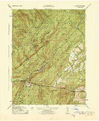
(7)- 1942 Map of Gettysburg, 1944 Print
 1942 Gettysburg1944 Print · USGSGettysburg and its surrounding borderlands are shown in great detail during the early 1940s, capturing the region's dense network of rural schools and mills. Genealogists can trace family-named landmarks such as Galt Kump PO, Hafers Mill, and Philips Delight Sch.
 - 1943 Map of Carlisle, 1944 Print
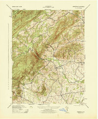
 1943 Carlisle1944 Print · USGSCumberland County during the mid-forties reveals a landscape transitioning between its deep industrial roots and new high-speed transit. Genealogists and historians can trace family locations through numerous rural landmarks like Farmers Academy, Reading Banks, and the Carlisle Barracks.3 unique versions available
 - 1944 Map of Flat Ridge
 1944 Flat Ridge1944 Print · USGSThe South Mountain high country in the mid-1940s is defined by vast state forests and conservation lands. Hikers and historians can trace the Appalachian Trail past Caledonia Park, Strasbaugh School, and the Chambersburg Reservoir.6 unique versions available
 - 1944 Map of Arendtsville
 1944 Arendtsville1944 Print · USGSAdams County orchard country and the eastern slopes of South Mountain are captured here during the mid-1940s. Genealogists and local historians can locate several rural schoolhouses, including Shellys School, and old mill sites like Genoltz Mill near Arendtsville.7 unique versions available
 - 1944 Map of Biglerville
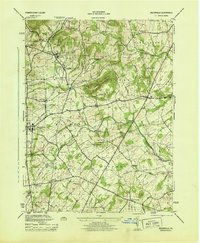 1944 Biglerville1944 Print · USGSAdams County’s orchard country and rail corridors are preserved here at the height of the mid-century fruit packing era. Genealogists and historians can trace family locations near Rock Chapel School, the H G Baugher Fruit Packing Co, and old rail stops like Bendersville Sta.5 unique versions available
 - 1945 Map of Newville
 1945 Newville1945 Print · USGSCumberland County at the end of the war shows a landscape where the new turnpike crosses a valley of established farms and mills. Researchers can trace family-named sites like Elliotts Mill, the Greythorne Walnut Bottom PO, and schools like Bluehill Sch.
 - 1948 Map of Baltimore
 1948 Baltimore1948 Print · USGSMaryland and Pennsylvania crossroads are captured in the late 1940s, showing a landscape defined by historic rail lines and major military installations. Genealogists can trace family connections in Gettysburg, Westminster, and near the U.S. Naval Academy in Annapolis.2 unique versions available
End of results
Showing maps 1-7 of 7
Top cities near Menallen Township
- Carlisle historical maps
- Gettysburg historical maps
- Middlesex Township historical maps
- Quincy Township historical maps
- Shippensburg historical maps
- Dickinson historical maps
See more
Top neighborhoods of Menallen Township
- Aspers historical maps
- Aspers historical maps
- Floradale historical maps
- Brysonia historical maps
- Wenksville historical maps
- Mount Tabor historical maps
Frequently asked questions
- What are the different types of historical maps available for Menallen Township?
- What is the oldest map of Menallen Township?
- Where can I purchase historical maps of Menallen Township for my home or office?
- Where can I download high-res historical maps of Menallen Township?
- Are there historical topographic maps available for Menallen Township?
- Is there historical aerial imagery available for Menallen Township?
- Where are historical maps of Menallen Township sourced from?