1960s Maps of Collier Township, Pennsylvania
Explore 24 historic maps of Collier Township from the 1960s. These maps offer a rare glimpse into what life looked like during the 1960s — showing old roads, neighborhoods, homes, and landmarks that have changed or disappeared over time.
Whether you're researching your family's past, planning a metal detecting trip, or studying how Collier Township's landscape evolved across the 1960s, these high-resolution maps are a powerful tool for exploring the history of this region.
- Focus on a specific era: All maps on this page are from the 1960s, giving you a focused view of this time period.
- See what’s changed: Compare century-old streets, trails, and buildings to today's modern landscape using overlays and satellite layers.
- Research with precision: Use these maps for genealogy, historical research, land use analysis, or educational projects.
- View, download, or print: Maps are fully viewable online in high resolution, and can be downloaded or printed for your own records.
Start exploring Collier Township's history through authentic maps from the 1960s. This is your window into the past.
Collier Township, PA maps
- 1960 Map of Oakdale
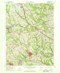 1960 Oakdale1960 Print · USGSAllegheny County during the expansion of the mid-century reveals a landscape caught between the industrial past and the modern jet age. Genealogists and local historians can trace the footprint of coal at Cliff Mine, institutional history at Woodville State Hospital, and early aviation at the Greater Pittsburgh Airport.7 unique versions available
 - 1960 Map of Pittsburgh West, 1961 Print
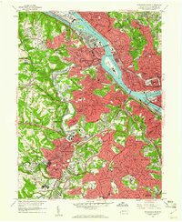 1960 Pittsburgh West1961 Print · USGSThe industrial heart of Allegheny County is shown here in the early 1960s, documenting the dense riverfront and hilly residential boroughs. Researchers can trace the massive Western State Penitentiary, find family roots in Uniondale Cemetery, or locate the old Woodville State Hospital.4 unique versions available
 - 1960 Map of Bridgeville, 1961 Print
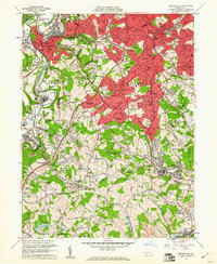 1960 Bridgeville1961 Print · USGSAllegheny and Washington counties are captured at a peak of suburban growth in the early sixties. Genealogists and local historians can trace the foundations of Castle Shannon and Bridgeville, or locate family sites near St Casimir Cem and Mayview State Hospital.6 unique versions available
 - 1960 Map of Canonsburg, 1961 Print
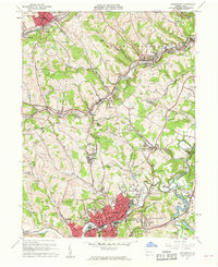 1960 Canonsburg1961 Print · USGSWashington County at the start of the sixties reveals a landscape of deep coal heritage and industrial rail hubs. Genealogists and historians can trace the foundations of Canonsburg and Houston or locate rural landmarks like St Marys Cem and Ship Mine.5 unique versions available
 - 1962 Map of Canton
 1962 Canton1962 Print · USGSThe industrial heartland of Eastern Ohio and Western Pennsylvania thrives in the early sixties as steel mills and rail lines dominate the river valleys. Genealogists and historians can trace local landmarks like McKinley National Memorial, Malone College, and industrial sites such as Republic Steel Corp.2 unique versions available
End of results
Showing maps 1-5
Top cities near Collier Township
- Pittsburgh historical maps
- Bethel Park historical maps
- Ross Township historical maps
- Mount Lebanon historical maps
- McCandless historical maps
- Moon Township historical maps
See more
Top neighborhoods of Collier Township
- Beechmont historical maps
- Gregg historical maps
- Kirwan Heights historical maps
- Presto historical maps
- Ewingsville historical maps
- Hickman historical maps
See more
Frequently asked questions
- What are the different types of historical maps available for Collier Township?
- What is the oldest map of Collier Township?
- Where can I purchase historical maps of Collier Township for my home or office?
- Where can I download high-res historical maps of Collier Township?
- Are there historical topographic maps available for Collier Township?
- Is there historical aerial imagery available for Collier Township?
- Where are historical maps of Collier Township sourced from?