1990s Maps of Elizabeth Township, Pennsylvania
Explore 3 historic maps of Elizabeth Township from the 1990s. These maps offer a rare glimpse into what life looked like during the 1990s — showing old roads, neighborhoods, homes, and landmarks that have changed or disappeared over time.
Whether you're researching your family's past, planning a metal detecting trip, or studying how Elizabeth Township's landscape evolved across the 1990s, these high-resolution maps are a powerful tool for exploring the history of this region.
- Focus on a specific era: All maps on this page are from the 1990s, giving you a focused view of this time period.
- See what’s changed: Compare century-old streets, trails, and buildings to today's modern landscape using overlays and satellite layers.
- Research with precision: Use these maps for genealogy, historical research, land use analysis, or educational projects.
- View, download, or print: Maps are fully viewable online in high resolution, and can be downloaded or printed for your own records.
Start exploring Elizabeth Township's history through authentic maps from the 1990s. This is your window into the past.
Elizabeth Township, PA maps
(3)- 1993 Map of Donora
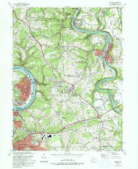 1993 Donora1993 Print · USGSThe industrial river valleys of the Monongahela and Youghiogheny are captured in the early nineties as they balance legacy industry with growing suburbs. Genealogists can trace family roots through sites like Douglass Cem, Apples Mill Ch, and the Concord Pioneer Sch.2 unique versions available
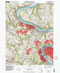
 - 1993 Map of Mc Keesport, 1998 Print
 1993 Mc Keesport1998 Print · USGSIn the late twentieth century, the industrial river valleys of Allegheny County show a complex blend of dense urban centers and sprawling memorial parks. Researchers can trace family ties through numerous local landmarks like St Nicholas Cem, Mt Vernon Cemetery, and the North Buena Vista Historical Site.
 - 1993 Map of Monongahela, 1999 Print
 1993 Monongahela1999 Print · USGSThe industrial Monongahela Valley is captured in the early nineties, showing a landscape shaped by river commerce and mining. Researchers can trace family roots at Taylor Cem or locate historic landmarks like Shire Oaks and Hazel Kirk.
End of results
Showing maps 1-3 of 3
Top cities near Elizabeth Township
- Pittsburgh historical maps
- Penn Hills historical maps
- Bethel Park historical maps
- Ross Township historical maps
- Mount Lebanon historical maps
- Monroeville historical maps
See more
Top neighborhoods of Elizabeth Township
- Victory historical maps
- Blythedale historical maps
- Douglass historical maps
- Mustard historical maps
- Smithdale historical maps
- Wylie historical maps
See more
Frequently asked questions
- What are the different types of historical maps available for Elizabeth Township?
- What is the oldest map of Elizabeth Township?
- Where can I purchase historical maps of Elizabeth Township for my home or office?
- Where can I download high-res historical maps of Elizabeth Township?
- Are there historical topographic maps available for Elizabeth Township?
- Is there historical aerial imagery available for Elizabeth Township?
- Where are historical maps of Elizabeth Township sourced from?