1940s Maps of Berks County, Pennsylvania
Explore 21 historic maps of Berks County from the 1940s. These maps offer a rare glimpse into what life looked like during the 1940s — showing old roads, neighborhoods, homes, and landmarks that have changed or disappeared over time.
Whether you're researching your family's past, planning a metal detecting trip, or studying how Berks County's landscape evolved across the 1940s, these high-resolution maps are a powerful tool for exploring the history of this region.
- Focus on a specific era: All maps on this page are from the 1940s, giving you a focused view of this time period.
- See what’s changed: Compare century-old streets, trails, and buildings to today's modern landscape using overlays and satellite layers.
- Research with precision: Use these maps for genealogy, historical research, land use analysis, or educational projects.
- View, download, or print: Maps are fully viewable online in high resolution, and can be downloaded or printed for your own records.
Start exploring Berks County's history through authentic maps from the 1940s. This is your window into the past.
Berks County, PA maps
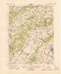
(21)- 1941 Map of Honeybrook
 1941 Honeybrook1941 Print · USGSSoutheastern Pennsylvania at the onset of the Second World War shows a landscape of established farm communities and the newly cut path of the Pennsylvania Turnpike. Researchers can locate numerous local landmarks such as Silver Hill School, Stone Church, and the rail stops along the Reading Lines.
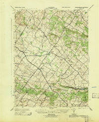
 - 1941 Map of New Holland
 1941 New Holland1941 Print · USGSLancaster County’s agricultural heartland is documented here just as the modern highway era arrived. Genealogists and local historians can trace family locations through dozens of named rural landmarks like Heller Church, Fetter School, and the Pennsylvania RR corridor.
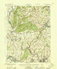
 - 1942 Map of Allentown West
 1942 Allentown West1942 Print · USGSLehigh County during the early war years displays a landscape of industrial river towns and agrarian crossroads. Researchers can locate dozens of country schools like Snyder Sch, historic landmarks like Cedar Crest College, and the sprawling Trexler Game Preserve.3 unique versions available
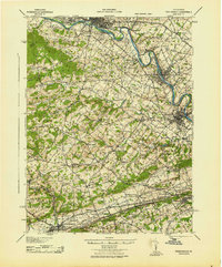
 - 1943 Map of Lebanon
 1943 Lebanon1943 Print · USGSMid-century Pennsylvania life is captured here during the Second World War, showing the expansion of the Lebanon Valley rail and road networks. Genealogists can locate family landmarks such as the Heidelberg Meeting House, Kimmerlings Ch, and numerous rural schools like Monroe Valley Sch.2 unique versions available
 - 1943 Map of Wernersville
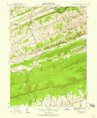
 1943 Wernersville1943 Print · USGSSoutheastern Pennsylvania farmland and rail towns are captured here during the wartime era, showing the intersection of Berks, Lebanon, and Lancaster counties. Genealogists and local researchers can trace historic institutions like Bethany Orphans Home or the Blue Meeting House.2 unique versions available
 - 1943 Map of Manatawny
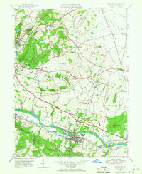
 1943 Manatawny1943 Print · USGSBerks County's rural townships are captured in detail during the early war years, showing a landscape of traditional farmsteads and small crossroads communities. Genealogists and historians can trace family locations near Hill Church, Landis Store, and along the Reading rail line.
 - 1943 Map of East Greenville
 1943 East Greenville1943 Print · USGSSoutheast Pennsylvania at the height of the war years reveals a landscape of dense small settlements and rural industry. Genealogists and historians can trace family roots through the grids of East Greenville and Pennsburg or locate landmarks like Huffs Church and Seisholtzville.
 - 1943 Map of Sassamansville
 1943 Sassamansville1943 Print · USGSMontgomery County was a patchwork of small townships and crossroads hamlets during the mid-forties. Genealogists and local historians can trace the early footprints of Gilbertsville, Sassamansville, and Frederick, or locate the specific grounds of Ringing Rock Park.
 - 1943 Map of Boyertown
 1943 Boyertown1943 Print · USGSBerks and Montgomery counties are shown at a wartime peak of rail and river industry, centered on the growing boroughs of Boyertown and Pottstown. Genealogists and historians can trace the mid-century layout of Pine Forge, the historic Schuylkill Canal, and local landmarks like Half Way House.
 - 1943 Map of Phoenixville
 1943 Phoenixville1943 Print · USGSSoutheastern Pennsylvania during the early war years shows a landscape defined by the winding Schuylkill River and heavy rail traffic. Genealogists and historians can trace the early Pennsylvania Turnpike and explore historic locales like Fricks Lock and Nantmeal Village.
 - 1944 Map of Reading
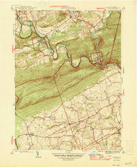
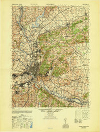
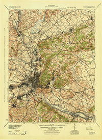 1944 Reading1944 Print · USGSReading and its surrounding Berks County townships appear here during the height of the mid-century industrial era. Genealogists and historians can trace family locations through dozens of named schools like Shirk Sch and Cedar top Sch, or locate ancestral sites at Oley Furnace and Charles Evans Cem.
 - 1944 Map of Newark, 1971 Print
 1944 Newark1971 Print · USGSThe industrial corridor from Philadelphia to New York was in a period of massive transition during the mid-forties. Genealogists and researchers can trace the rail lines of the Lehigh Valley RR, locate military installations like Picatinny Arsenal, and explore the early sprawl near Levittown.5 unique versions available
 - 1945 Map of Friedensburg, 1958 Print
 1945 Friedensburg1958 Print · USGSSchuylkill County at the end of the war is a landscape of valley townships and ridge-top trails. Genealogists can trace a dense network of rural schools and villages like Friedensburg, Summit Station, and Brommerstown, alongside the early route of the Appalachian Trail.7 unique versions available
 - 1945 Map of Auburn, 1958 Print
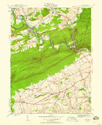 1945 Auburn1958 Print · USGSMid-century Berks and Schuylkill counties are defined here by the industrial corridor of the Schuylkill River and the high ridge of Blue Mountain. Trace ancestral roots at St Michaels Ch or locate vanished local schools like Jefferson Sch and Mangel Sch.6 unique versions available
 - 1946 Map of Pine Grove
 1946 Pine Grove1946 Print · USGSSchuylkill County in the mid-1940s is a landscape of tight mountain ridges and busy rail corridors serving coal-country towns. Genealogists and researchers can trace local landmarks like Jacobs Ch, the Swatara Valley Airport, and the Reading railroad spurs through Suedberg and Lorberry.2 unique versions available
 - 1946 Map of Auburn
 1946 Auburn1946 Print · USGSSchuylkill and Berks counties met at the river gap during the mid-forties, where heavy rail and the mountain ridge defined local life. Genealogists can locate family-named schools like Mangel Sch and Jefferson Sch or trace the Appalachian Trail past Port Clinton.2 unique versions available
 - 1946 Map of Friedensburg
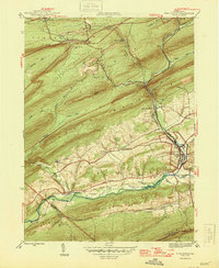
 1946 Friedensburg1946 Print · USGSSchuylkill and Berks counties appear here shortly after the war, showing the mountain ridges and valley towns of the mid-1940s. Trace local family history at Friedensburg, old rural schools like Panther Valley Sch, or the path of the Appalachian Trail.2 unique versions available
 - 1946 Map of Swatara Hill
 1946 Swatara Hill1946 Print · USGSSchuylkill and Berks counties are shown in the 1940s as a landscape of ridge-and-valley farming and early mountain recreation. Genealogists can locate family landmarks like Manbeck Cem or tracing historic schoolhouses such as Kershner Sch and Fidler Sch.2 unique versions available
 - 1946 Map of Reading
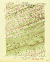
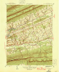
 1946 Reading1946 Print · USGSBerks County's industrial and agricultural heartland is documented here just after the war, centered on the bustling hub of Reading. Genealogists and historians can trace family-named landmarks like Hecktown Sch, Friends Meeting House, and Van Reeds Mill.
 - 1947 Map of Birdsboro, 1967 Print
 1947 Birdsboro1967 Print · USGSBerks County’s industrial and colonial history converge along the Schuylkill River in the late 1940s. Genealogists and historians can trace family sites like the Daniel Boone Homestead and the Exeter Friends Meeting House.4 unique versions available
 - 1949 Map of Newark
 1949 Newark1949 Print · USGSThe industrial corridor between Philadelphia and New York comes alive in this post-war survey. Genealogists and historians can trace the massive rail networks of the Reading Railroad and locate major installations like Fort Dix or Picatinny Arsenal.2 unique versions available
End of results
Showing maps 1-21 of 21
Top cities of Berks County
- Reading historical maps
- Wyomissing historical maps
- Maxatawny Township historical maps
- Longswamp Township historical maps
- Birdsboro historical maps
- Kutztown historical maps
See more
Frequently asked questions
- What are the different types of historical maps available for Berks County?
- What is the oldest map of Berks County?
- Where can I purchase historical maps of Berks County for my home or office?
- Where can I download high-res historical maps of Berks County?
- Are there historical topographic maps available for Berks County?
- Is there historical aerial imagery available for Berks County?
- Where are historical maps of Berks County sourced from?