1990s Maps of Berks County, Pennsylvania
Explore 26 historic maps of Berks County from the 1990s. These maps offer a rare glimpse into what life looked like during the 1990s — showing old roads, neighborhoods, homes, and landmarks that have changed or disappeared over time.
Whether you're researching your family's past, planning a metal detecting trip, or studying how Berks County's landscape evolved across the 1990s, these high-resolution maps are a powerful tool for exploring the history of this region.
- Focus on a specific era: All maps on this page are from the 1990s, giving you a focused view of this time period.
- See what’s changed: Compare century-old streets, trails, and buildings to today's modern landscape using overlays and satellite layers.
- Research with precision: Use these maps for genealogy, historical research, land use analysis, or educational projects.
- View, download, or print: Maps are fully viewable online in high resolution, and can be downloaded or printed for your own records.
Start exploring Berks County's history through authentic maps from the 1990s. This is your window into the past.
Berks County, PA maps
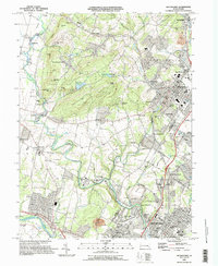
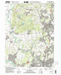
(26)- 1992 Map of New Ringgold, 1994 Print
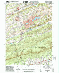
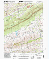
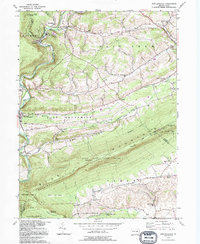 1992 New Ringgold1994 Print · USGSBlue Mountain and the Schuylkill valley dominate this 1990s portrait of rural Pennsylvania conservation and settlement. Genealogists and hikers can trace the Appalachian Trail past Hawk Mountain Sanctuary or locate historic family landmarks like Steigerwalts Sch and Bolich Ch.
 - 1992 Map of East Greenville, 1995 Print
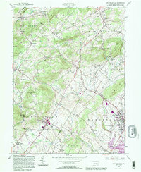 1992 East Greenville1995 Print · USGSThe Pennsylvania Dutch country comes to life in the early nineties, showing the intersection of Berks, Lehigh, and Montgomery counties. Researchers can trace historic family names through the New Goshenhoppen Ch, the old borough of Bally, and several rural burial sites like Bethesda Cem.
 - 1992 Map of Bernville, 1995 Print
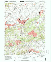
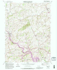 1992 Bernville1995 Print · USGSThe Berks County countryside comes into focus in the early nineties as it transitions from the rural crossroads of Bernville to the wide waters of Blue Marsh Lake. Researchers can trace local landmarks like Werts Bridge, Bellemans Ch, and the Stump Cem.
 - 1992 Map of Bethel, 1995 Print
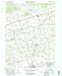 1992 Bethel1995 Print · USGSThe Berks and Lebanon county line area comes to life in this detailed late-century survey of rural Pennsylvania townships. Genealogists and historians can trace family-named sites like Merkey Ch, the historic Union Canal, and the old mills at Crosskill Mills.
 - 1995 Map of Boyertown, 1996 Print
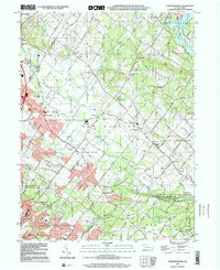
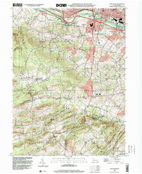
 1995 Boyertown1996 Print · USGSThe Berks and Montgomery county line in the mid-1990s shows a landscape of historic industrial river towns and rural upland ridges. Genealogists and local historians can trace family-named landmarks and old hamlets like Pine Forge, Woodchoppertown, and Douglassville.
 - 1997 Map of Elverson, 1998 Print
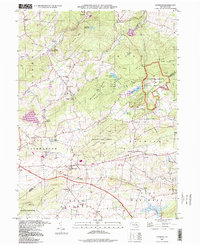 1997 Elverson1998 Print · USGSSoutheast Pennsylvania's iron heritage and wooded ridges are preserved here in the late twentieth century. Genealogists and historians can trace family roots through sites like Scarlets Mill, Bethesda Ch, and the preserved Hopewell Village.
 - 1997 Map of New Ringgold, 1998 Print
 1997 New Ringgold1998 Print · USGSThe Blue Mountain ridge and Schuylkill River valley define this rural Pennsylvania landscape in the late nineties. Genealogists and hikers can trace the Appalachian Trail past Hawk Mountain Sanctuary or locate family sites like Bolich Ch and Eckville.
 - 1997 Map of Kutztown, 1999 Print
 1997 Kutztown1999 Print · USGSKutztown and the surrounding Berks County farmlands are captured here in the late twentieth century. Researchers can trace the legacy of local education and faith at Kutztown State Teachers College, Moselem Ch, and the Old Order Ch.
 - 1997 Map of Boyertown, 2000 Print
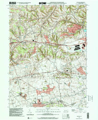
 1997 Boyertown2000 Print · USGSThe Berks and Montgomery county line comes alive in the late nineties, documenting a region of deep-rooted settlements and evolving industry. Genealogists can trace family landmarks like Shanesville Ch, find long-standing cemeteries such as Union Cem, and follow the Colebrookdale Branch rail line.
 - 1999 Map of Sassamansville, 2001 Print
 1999 Sassamansville2001 Print · USGSEastern Montgomery County in the late nineties maintains its historic character while integrating modern utility. Researchers can locate family landmarks like St Pauls Cem and Herstien Chapel, or trace old mill sites along Swamp Creek near Frederick.
 - 1999 Map of Topton, 2001 Print
 1999 Topton2001 Print · USGSThe Berks and Lehigh county line comes alive in the late nineties, documenting a landscape of established farmsteads and rural boroughs. Genealogists can trace family roots through historic sites like Shamrock Station, St Pauls Church, and Leather Corner Post.
 - 1999 Map of Terre Hill, 2001 Print
 1999 Terre Hill2001 Print · USGSNortheastern Lancaster County at the end of the century retains its traditional rural layout despite the path of the Pennsylvania Turnpike. Genealogists and historians can trace numerous local landmarks including Salem Cem, Reddenbach Ch, and the many schools of East Earl.
 - 1999 Map of Friedensburg, 2001 Print
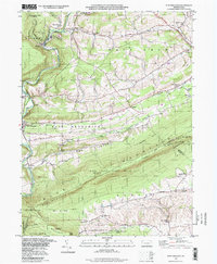
 1999 Friedensburg2001 Print · USGSSchuylkill County at the end of the millennium shows a landscape shaped by the ridge of Blue Mountain and a network of valley settlements. Genealogists and historians can locate several local schools such as Black Horse Sch and Reber Sch, or trace the path of the Appalachian National Scenic Trail.
 - 1999 Map of Birdsboro, 2001 Print
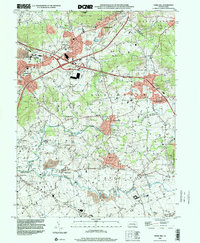
 1999 Birdsboro2001 Print · USGSBerks County at the turn of the millennium shows a deep layering of colonial history and industrial transit along the Schuylkill River. Genealogists and historians can trace family-named landmarks like the Daniel Boone Homestead, de Benneville House, and Stonetown.
 - 1999 Map of Reading, 2001 Print
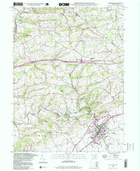
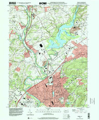
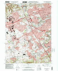
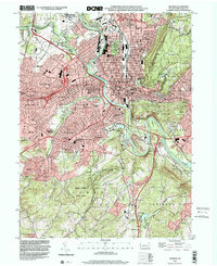 1999 Reading2001 Print · USGSGreater Reading at the close of the twentieth century shows a complex landscape of urban growth and preserved woodland. Genealogists and local historians can trace family locations through numerous sites like Charles Evans Cemetery, Kissinger Union Ch, and Governor Mifflin High Sch.
 - 1999 Map of Sinking Spring, 2001 Print
 1999 Sinking Spring2001 Print · USGSSinking Spring and the South Mountain slopes are shown at the turn of the millennium, as suburban expansion meets historic institutions. Researchers can trace the grounds of the Wernersville State Hospital, old burial sites like Pleasant View Cem, and the path of the CONRAIL line.
 - 1999 Map of New Tripoli, 2001 Print
 1999 New Tripoli2001 Print · USGSLehigh and Schuylkill counties are captured here at the close of the twentieth century as rural landscapes met conservation efforts. Trace local genealogy and infrastructure through New Jerusalem Ch, Ulrichs Bridge, and the Appalachian Scenic Trail.
 - 1999 Map of Fredericksburg, 2001 Print
 1999 Fredericksburg2001 Print · USGSThe northern Lebanon County valley was a landscape of small farms and wooded ridges at the turn of the millennium. Researchers can trace the development of local hamlets and rural schoolhouses like Shirksville, West Jonestown, and the Umberger Sch.
 - 1999 Map of Auburn, 2001 Print
 1999 Auburn2001 Print · USGSSchuylkill and Berks counties met at the turn of the millennium along the steep ridges of Blue Mountain and the winding river valleys. Researchers can trace rural schoolhouse locations like Tunnel Sch and historic local congregations at Salem Ch or St Michaels Ch.
 - 1999 Map of Temple, 2001 Print
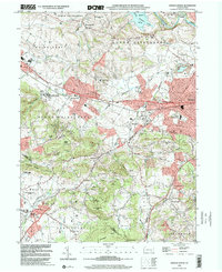
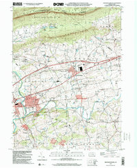
 1999 Temple2001 Print · USGSBerks County is shown at the end of the twentieth century as suburban growth and industrial infrastructure expand around the Schuylkill River. Researchers can locate family landmarks like St Johns Ch and Birch Hill Cem or trace the shoreline of Lake Ontelaunee.
 - 1999 Map of Morgantown, 2001 Print
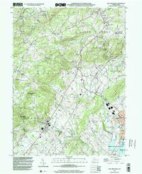
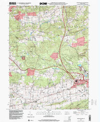 1999 Morgantown2001 Print · USGSThe Pennsylvania countryside at the end of the century shows a blend of rural heritage and industrial sites where Berks, Lancaster, and Chester counties meet. Researchers can trace family sites from Grace Mine to Churchtown, including local landmarks like Joanna Furnace and Hummels Store.
 - 1999 Map of Allentown West, 2001 Print
 1999 Allentown West2001 Print · USGSThe Lehigh Valley at the turn of the millennium shows a blend of suburban growth and industrial heritage. Genealogists can trace old family sites near St Josephs Ch, while historians can locate the Lock Ridge Park and Furnace Museum or Dorney Park.
 - 1999 Map of Fleetwood, 2001 Print
 1999 Fleetwood2001 Print · USGSBerks County at the end of the millennium retains its distinct pattern of rural schoolhouses and furnace hamlets. Genealogists can locate family landmarks like Lesher Cem, Dreibelbis Sch, and the historic industrial site at Oley Furnace.
 - 1999 Map of Pottstown, 2001 Print
 1999 Pottstown2001 Print · USGSAs the millennium approached, the Schuylkill River valley maintained a dense network of rural villages and industrial centers across Chester and Montgomery counties. Researchers can trace historic family landmarks and local institutions like St Peters Ch, Coventryville, and the grounds of the Hill Sch.
 - 1999 Map of East Greenville, 2002 Print
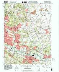
 1999 East Greenville2002 Print · USGSThe crossroads villages and wooded ridges of the Lehigh and Montgomery county line are captured here as they appeared at the end of the century. Genealogists can trace family roots through historic sites like Old Zionsville, Huffs Church, and New Goshenhoppen Ch.
Showing maps 1-25 of 26
Top cities of Berks County
- Reading historical maps
- Wyomissing historical maps
- Maxatawny Township historical maps
- Longswamp Township historical maps
- Birdsboro historical maps
- Kutztown historical maps
See more
Frequently asked questions
- What are the different types of historical maps available for Berks County?
- What is the oldest map of Berks County?
- Where can I purchase historical maps of Berks County for my home or office?
- Where can I download high-res historical maps of Berks County?
- Are there historical topographic maps available for Berks County?
- Is there historical aerial imagery available for Berks County?
- Where are historical maps of Berks County sourced from?