Old Maps of Berks County, Pennsylvania for Academic Research
Study the evolution of Berks County with 141 high-resolution historic maps. Whether you're teaching, researching, or modeling changes in land use, these maps provide essential visual documentation of urban, environmental, and geographic change.
- Analyze long-term change: Track patterns in development, transportation, and natural features.
- Ideal for environmental or urban studies: Support academic projects with primary historical map data.
- Use in the classroom or lab: Educators and researchers rely on these maps to bring historical context to life.
These maps are a powerful tool for teaching, research, and visualizing how Berks County has changed over the decades.
Berks County, PA maps
(141)- 1889 Map of Pottsville, 1964 Print
 1889 Pottsville1964 Print · USGSAnthracite coal country and the complex rail networks of the late nineteenth century dominate this survey of the Schuylkill River valley. Genealogists and industrial historians can trace the early footprints of Pottsville, Schuylkill Haven, and the numerous rail branches serving New Philadelphia and Port Carbon.
 - 1891 Map of Pottsville
 1891 Pottsville1891 Print · USGSSchuylkill County enters its industrial height in the 1890s, when anthracite coal and iron rails reshaped the mountains. Trace the dense rail networks of the Philadelphia and Reading Railroad connecting Pottsville, St. Clair, and Schuylkill Haven.10 unique versions available
 - 1891 Map of Lebanon
 1891 Lebanon1891 Print · USGSLebanon and its surrounding iron-rich valleys are captured here in the late nineteenth century at the height of the local railroad era. Genealogists can trace family lines through old post offices like Greenville (Greble P.O.) or early stops on the Cornwall Railroad.
 - 1892 Map of Pine Grove
 1892 Pine Grove1892 Print · USGSSchuylkill County coal country comes alive in the late 1800s, showing a landscape defined by sharp ridges and heavy industry. Genealogists and historians can trace rail-dependent mining towns like Minersville, Branch Dale, and the bustling junction at Tremont.10 unique versions available
 - 1893 Map of Lebanon
 1893 Lebanon1893 Print · USGSLate nineteenth-century Lebanon County is captured here at the height of its industrial iron and rail era. Genealogists can trace family roots in established centers like Cornwall, Meyerstown, and Schaefferstown, or locate the specific rail stops of the Philadelphia and Reading Railroad.
 - 1894 Map of Reading
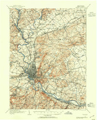
 1894 Reading1894 Print · USGSIn the 1890s, the industrial core of Berks County was defined by its coal-and-iron rail networks and the winding Schuylkill River. Genealogists and historians can trace late-nineteenth-century life in Reading and surrounding villages like Shoemakersville or find local landmarks such as Spies Church.5 unique versions available
 - 1899 Map of Lebanon
 1899 Lebanon1899 Print · USGSLebanon County at the close of the century shows a landscape defined by its iron-ore heritage and a bustling network of independent railroads. Genealogists and researchers can trace the old rail lines serving Cornwall, locate long-standing villages like Schaefferstown, and follow the winding course of Tulpehocken Creek.9 unique versions available
 - 1902 Map of Boyertown
 1902 Boyertown1902 Print · USGSSoutheast Pennsylvania at the dawn of the century reveals an intricate landscape of iron-era settlements and early rail networks. Genealogists and historians can trace the foundations of Boyertown, locate rural landmarks like Landis Store, or follow the path of the Schuylkill Canal.9 unique versions available
 - 1902 Map of Wernersville
 1902 Wernersville1902 Print · USGSBerks and Lebanon counties at the start of the twentieth century show a landscape defined by industrial rail lines and agricultural valleys. Trace family roots at the Orphans Home or locate landmarks like Krick's Mill and Eagle Peak.8 unique versions available
 - 1902 Map of Slatington
 1902 Slatington1902 Print · USGSLehigh County's industrial and quarrying heart comes into focus at the dawn of the 1900s. Researchers can trace the path of the Lehigh Canal and locate family landmarks like Peters Store, Jordan Church, and the Consolidated Quarries.5 unique versions available
 - 1905 Map of Honey Brook, 1962 Print
 1905 Honey Brook1962 Print · USGSSoutheastern Pennsylvania at the start of the twentieth century shows a landscape shaped by iron furnaces and a dense rail network. Genealogists can trace family footprints at Joanna Furnace, Hummels Store, and numerous rural sites like Silver Hill School.
 - 1906 Map of Phoenixville
 1906 Phoenixville1906 Print · USGSThe industrial corridor along the Schuylkill River thrives in the early 1900s as rail networks expand through Chester and Montgomery counties. Genealogists and historians can trace old community centers like Seven Stars, Limerick, and the Paoli Monument.8 unique versions available
 - 1906 Map of New Holland, 1962 Print
 1906 New Holland1962 Print · USGSLancaster County at the start of the twentieth century shows a landscape transitioning from turnpikes to electric railways. Genealogists can trace family roots through an extensive network of rural landmarks, including Heller Church, Red Well School, and the early Waterworks at Ephrata.
 - 1907 Map of Honeybrook
 1907 Honeybrook1907 Print · USGSSoutheast Pennsylvania at the start of the twentieth century shows a landscape defined by small hamlets and early rail lines. Genealogists can trace family names and local hubs from Honeybrook and Churchtown to rural landmarks like Spoketown School and Harmony Church.7 unique versions available
 - 1908 Map of New Holland
 1908 New Holland1908 Print · USGSLancaster County at the turn of the century shows a thriving landscape of rural schoolhouses and turnpike villages. Genealogists can locate family landmarks like Middle Creek Church, Heller Church, and dozens of local schools from Stony Hill School to Clay School.6 unique versions available
 - 1909 Map of Hamburg, 1957 Print
 1909 Hamburg1957 Print · USGSSchuylkill and Berks counties are captured here during the height of the steam era, showing the intricate relationship between the mountain gaps and the rail lines. Genealogists and researchers can trace old postal routes through Wessnersville Stony Run P O, locate the historic Five Locks, and identify family farms near Crystal Cave.
 - 1911 Map of Hamburg
 1911 Hamburg1911 Print · USGSBerks and Schuylkill counties are captured here at a peak of rail-driven rural life just before the Great War. Researchers can trace family roots through specific locales like New Ringgold, Dorset Sta, and the historic Five Locks along the Schuylkill River.5 unique versions available
 - 1913 Map of Reading, 1954 Print
 1913 Reading1954 Print · USGSThe Schuylkill valley near the turn of the century shows a landscape transitioning between its colonial iron roots and a modern rail-driven economy. Genealogists and historians can trace family locations near the Friends Meetinghouse, Van Reeds Mill, or the many district schoolhouses like Neff School.
 - 1915 Map of Reading
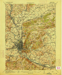 1915 Reading1915 Print · USGSBerks County at the height of its industrial and rail era shows a landscape where iron furnaces and canals meet growing boroughs. Trace the paths of the Schuylkill Canal, locate old sites like Oley Furnace, or find family landmarks like Gernant Church and Epler School.6 unique versions available
 - 1937 Map of Allentown West
 1937 Allentown West1937 Print · USGSLehigh County at the end of the Depression era reveals a dense network of rural schoolhouses and crossroads hamlets before post-war expansion. Genealogists can trace family names at James Peters Sch or Heidelberg Sch, and locate landmarks like Schantz Spr and Rising Sun.
 - 1941 Map of Honeybrook
 1941 Honeybrook1941 Print · USGSSoutheastern Pennsylvania at the onset of the Second World War shows a landscape of established farm communities and the newly cut path of the Pennsylvania Turnpike. Researchers can locate numerous local landmarks such as Silver Hill School, Stone Church, and the rail stops along the Reading Lines.
 - 1941 Map of New Holland
 1941 New Holland1941 Print · USGSLancaster County’s agricultural heartland is documented here just as the modern highway era arrived. Genealogists and local historians can trace family locations through dozens of named rural landmarks like Heller Church, Fetter School, and the Pennsylvania RR corridor.
 - 1942 Map of Allentown West
 1942 Allentown West1942 Print · USGSLehigh County during the early war years displays a landscape of industrial river towns and agrarian crossroads. Researchers can locate dozens of country schools like Snyder Sch, historic landmarks like Cedar Crest College, and the sprawling Trexler Game Preserve.3 unique versions available
 - 1943 Map of Lebanon
 1943 Lebanon1943 Print · USGSMid-century Pennsylvania life is captured here during the Second World War, showing the expansion of the Lebanon Valley rail and road networks. Genealogists can locate family landmarks such as the Heidelberg Meeting House, Kimmerlings Ch, and numerous rural schools like Monroe Valley Sch.2 unique versions available
 - 1943 Map of Wernersville
 1943 Wernersville1943 Print · USGSSoutheastern Pennsylvania farmland and rail towns are captured here during the wartime era, showing the intersection of Berks, Lebanon, and Lancaster counties. Genealogists and local researchers can trace historic institutions like Bethany Orphans Home or the Blue Meeting House.2 unique versions available
Showing maps 1-25 of 141
Top cities of Berks County
- Reading historical maps
- Wyomissing historical maps
- Maxatawny Township historical maps
- Longswamp Township historical maps
- Birdsboro historical maps
- Kutztown historical maps
See more
Frequently asked questions
- What are the different types of historical maps available for Berks County?
- What is the oldest map of Berks County?
- Where can I purchase historical maps of Berks County for my home or office?
- Where can I download high-res historical maps of Berks County?
- Are there historical topographic maps available for Berks County?
- Is there historical aerial imagery available for Berks County?
- Where are historical maps of Berks County sourced from?