1910s Maps of Richmond Township, Pennsylvania
Explore 3 historic maps of Richmond Township from the 1910s. These maps offer a rare glimpse into what life looked like during the 1910s — showing old roads, neighborhoods, homes, and landmarks that have changed or disappeared over time.
Whether you're researching your family's past, planning a metal detecting trip, or studying how Richmond Township's landscape evolved across the 1910s, these high-resolution maps are a powerful tool for exploring the history of this region.
- Focus on a specific era: All maps on this page are from the 1910s, giving you a focused view of this time period.
- See what’s changed: Compare century-old streets, trails, and buildings to today's modern landscape using overlays and satellite layers.
- Research with precision: Use these maps for genealogy, historical research, land use analysis, or educational projects.
- View, download, or print: Maps are fully viewable online in high resolution, and can be downloaded or printed for your own records.
Start exploring Richmond Township's history through authentic maps from the 1910s. This is your window into the past.
Richmond Township, PA maps
(3)- 1911 Map of Hamburg
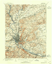
 1911 Hamburg1911 Print · USGSBerks and Schuylkill counties are captured here at a peak of rail-driven rural life just before the Great War. Researchers can trace family roots through specific locales like New Ringgold, Dorset Sta, and the historic Five Locks along the Schuylkill River.5 unique versions available
 - 1913 Map of Reading, 1954 Print
 1913 Reading1954 Print · USGSThe Schuylkill valley near the turn of the century shows a landscape transitioning between its colonial iron roots and a modern rail-driven economy. Genealogists and historians can trace family locations near the Friends Meetinghouse, Van Reeds Mill, or the many district schoolhouses like Neff School.
 - 1915 Map of Reading
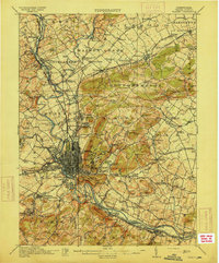 1915 Reading1915 Print · USGSBerks County at the height of its industrial and rail era shows a landscape where iron furnaces and canals meet growing boroughs. Trace the paths of the Schuylkill Canal, locate old sites like Oley Furnace, or find family landmarks like Gernant Church and Epler School.6 unique versions available
End of results
Showing maps 1-3 of 3
Top cities near Richmond Township
- Reading historical maps
- Pottstown historical maps
- Muhlenberg Park historical maps
- Wyomissing historical maps
- New Hanover Township historical maps
- Maxatawny Township historical maps
See more
Top neighborhoods of Richmond Township
- Virginville historical maps
- Walnuttown historical maps
- Moselem Springs historical maps
- Kempville historical maps
- Kirbyville historical maps
- Moselem historical maps
Frequently asked questions
- What are the different types of historical maps available for Richmond Township?
- What is the oldest map of Richmond Township?
- Where can I purchase historical maps of Richmond Township for my home or office?
- Where can I download high-res historical maps of Richmond Township?
- Are there historical topographic maps available for Richmond Township?
- Is there historical aerial imagery available for Richmond Township?
- Where are historical maps of Richmond Township sourced from?