1990s Maps of Upper Tulpehocken Township, Pennsylvania
Explore 3 historic maps of Upper Tulpehocken Township from the 1990s. These maps offer a rare glimpse into what life looked like during the 1990s — showing old roads, neighborhoods, homes, and landmarks that have changed or disappeared over time.
Whether you're researching your family's past, planning a metal detecting trip, or studying how Upper Tulpehocken Township's landscape evolved across the 1990s, these high-resolution maps are a powerful tool for exploring the history of this region.
- Focus on a specific era: All maps on this page are from the 1990s, giving you a focused view of this time period.
- See what’s changed: Compare century-old streets, trails, and buildings to today's modern landscape using overlays and satellite layers.
- Research with precision: Use these maps for genealogy, historical research, land use analysis, or educational projects.
- View, download, or print: Maps are fully viewable online in high resolution, and can be downloaded or printed for your own records.
Start exploring Upper Tulpehocken Township's history through authentic maps from the 1990s. This is your window into the past.
Upper Tulpehocken Township, PA maps
(3)- 1992 Map of Bernville, 1995 Print
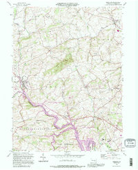 1992 Bernville1995 Print · USGSThe Berks County countryside comes into focus in the early nineties as it transitions from the rural crossroads of Bernville to the wide waters of Blue Marsh Lake. Researchers can trace local landmarks like Werts Bridge, Bellemans Ch, and the Stump Cem.
 - 1999 Map of Friedensburg, 2001 Print
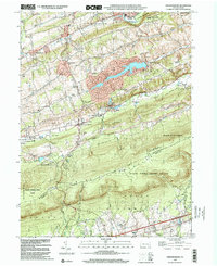 1999 Friedensburg2001 Print · USGSSchuylkill County at the end of the millennium shows a landscape shaped by the ridge of Blue Mountain and a network of valley settlements. Genealogists and historians can locate several local schools such as Black Horse Sch and Reber Sch, or trace the path of the Appalachian National Scenic Trail.
 - 1999 Map of Auburn, 2001 Print
 1999 Auburn2001 Print · USGSSchuylkill and Berks counties met at the turn of the millennium along the steep ridges of Blue Mountain and the winding river valleys. Researchers can trace rural schoolhouse locations like Tunnel Sch and historic local congregations at Salem Ch or St Michaels Ch.
End of results
Showing maps 1-3 of 3
Top cities near Upper Tulpehocken Township
- Reading historical maps
- Muhlenberg Park historical maps
- Pottsville historical maps
- Wyomissing historical maps
- Clay Township historical maps
- Schuylkill Haven historical maps
See more
Top neighborhoods of Upper Tulpehocken Township
Frequently asked questions
- What are the different types of historical maps available for Upper Tulpehocken Township?
- What is the oldest map of Upper Tulpehocken Township?
- Where can I purchase historical maps of Upper Tulpehocken Township for my home or office?
- Where can I download high-res historical maps of Upper Tulpehocken Township?
- Are there historical topographic maps available for Upper Tulpehocken Township?
- Is there historical aerial imagery available for Upper Tulpehocken Township?
- Where are historical maps of Upper Tulpehocken Township sourced from?