1990s Maps of Washington Township, Pennsylvania
Explore 6 historic maps of Washington Township from the 1990s. These maps offer a rare glimpse into what life looked like during the 1990s — showing old roads, neighborhoods, homes, and landmarks that have changed or disappeared over time.
Whether you're researching your family's past, planning a metal detecting trip, or studying how Washington Township's landscape evolved across the 1990s, these high-resolution maps are a powerful tool for exploring the history of this region.
- Focus on a specific era: All maps on this page are from the 1990s, giving you a focused view of this time period.
- See what’s changed: Compare century-old streets, trails, and buildings to today's modern landscape using overlays and satellite layers.
- Research with precision: Use these maps for genealogy, historical research, land use analysis, or educational projects.
- View, download, or print: Maps are fully viewable online in high resolution, and can be downloaded or printed for your own records.
Start exploring Washington Township's history through authentic maps from the 1990s. This is your window into the past.
Washington Township, PA maps
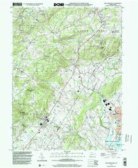
(6)- 1992 Map of East Greenville, 1995 Print
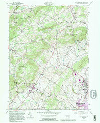 1992 East Greenville1995 Print · USGSThe Pennsylvania Dutch country comes to life in the early nineties, showing the intersection of Berks, Lehigh, and Montgomery counties. Researchers can trace historic family names through the New Goshenhoppen Ch, the old borough of Bally, and several rural burial sites like Bethesda Cem.
 - 1995 Map of Boyertown, 1996 Print
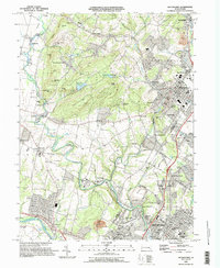 1995 Boyertown1996 Print · USGSThe Berks and Montgomery county line in the mid-1990s shows a landscape of historic industrial river towns and rural upland ridges. Genealogists and local historians can trace family-named landmarks and old hamlets like Pine Forge, Woodchoppertown, and Douglassville.
 - 1997 Map of Boyertown, 2000 Print
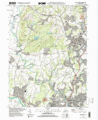 1997 Boyertown2000 Print · USGSThe Berks and Montgomery county line comes alive in the late nineties, documenting a region of deep-rooted settlements and evolving industry. Genealogists can trace family landmarks like Shanesville Ch, find long-standing cemeteries such as Union Cem, and follow the Colebrookdale Branch rail line.
 - 1999 Map of Sassamansville, 2001 Print
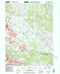 1999 Sassamansville2001 Print · USGSEastern Montgomery County in the late nineties maintains its historic character while integrating modern utility. Researchers can locate family landmarks like St Pauls Cem and Herstien Chapel, or trace old mill sites along Swamp Creek near Frederick.
 - 1999 Map of East Greenville, 2002 Print
 1999 East Greenville2002 Print · USGSThe crossroads villages and wooded ridges of the Lehigh and Montgomery county line are captured here as they appeared at the end of the century. Genealogists can trace family roots through historic sites like Old Zionsville, Huffs Church, and New Goshenhoppen Ch.
 - 1999 Map of Manatawny, 2002 Print
 1999 Manatawny2002 Print · USGSBerks County's rural townships are documented here during the late twentieth century, showing a landscape of ridgelines and small valleys. Researchers can locate family landmarks like Mountain Marys Grave, Hill Church, and the village of Landis Store.
End of results
Showing maps 1-6 of 6
Top cities near Washington Township
- Allentown historical maps
- Bethlehem historical maps
- Pottstown historical maps
- Limerick Township historical maps
- Skippack Township historical maps
- Franconia Township historical maps
See more
Top neighborhoods of Washington Township
Frequently asked questions
- What are the different types of historical maps available for Washington Township?
- What is the oldest map of Washington Township?
- Where can I purchase historical maps of Washington Township for my home or office?
- Where can I download high-res historical maps of Washington Township?
- Are there historical topographic maps available for Washington Township?
- Is there historical aerial imagery available for Washington Township?
- Where are historical maps of Washington Township sourced from?