1960s Maps of Blair Township, Pennsylvania
Explore 4 historic maps of Blair Township from the 1960s. These maps offer a rare glimpse into what life looked like during the 1960s — showing old roads, neighborhoods, homes, and landmarks that have changed or disappeared over time.
Whether you're researching your family's past, planning a metal detecting trip, or studying how Blair Township's landscape evolved across the 1960s, these high-resolution maps are a powerful tool for exploring the history of this region.
- Focus on a specific era: All maps on this page are from the 1960s, giving you a focused view of this time period.
- See what’s changed: Compare century-old streets, trails, and buildings to today's modern landscape using overlays and satellite layers.
- Research with precision: Use these maps for genealogy, historical research, land use analysis, or educational projects.
- View, download, or print: Maps are fully viewable online in high resolution, and can be downloaded or printed for your own records.
Start exploring Blair Township's history through authentic maps from the 1960s. This is your window into the past.
Blair Township, PA maps
(4)- 1963 Map of Hollidaysburg, 1965 Print
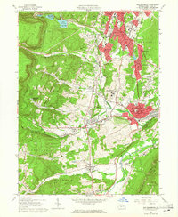 1963 Hollidaysburg1965 Print · USGSBlair County’s mid-century industrial and suburban growth is on full display during this era of rail and road expansion. Researchers can trace institutional landmarks like Hollidaysburg State Hospital and iconic engineering feats such as the Horseshoe Curve.5 unique versions available
 - 1963 Map of Frankstown, 1965 Print
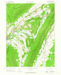 1963 Frankstown1965 Print · USGSBlair County in the early sixties shows a landscape where mountain ridges channel river life and industrial extraction. You can trace the remnants of an old railroad grade or locate ancestral sites like Eight Square Chapel and Royer Cem.4 unique versions available
 - 1963 Map of Roaring Spring, 1965 Print
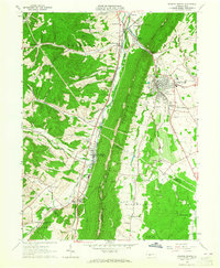 1963 Roaring Spring1965 Print · USGSThe valleys between DUNNING MOUNTAIN and SHORT MOUNTAIN were centers of industry and community in the early sixties. Researchers can trace family sites from Bakers Summit to Roaring Spring, locating Stowberger Cem, Albright Ch, and numerous local Quarries.4 unique versions available
 - 1964 Map of Pittsburgh
 1964 Pittsburgh1964 Print · USGSWestern Pennsylvania in the late fifties and early sixties shows a landscape of powerful river industries and expanding highways. Genealogists and historians can trace the rail corridors of the Pennsylvania RR through industrial hubs like Johnstown, Altoona, and Nanty Glo.
End of results
Showing maps 1-4 of 4
Top cities near Blair Township
- Altoona historical maps
- Frankstown Township historical maps
- Hollidaysburg historical maps
- Roaring Spring historical maps
- Martinsburg historical maps
- Bellwood historical maps
See more
Top neighborhoods of Blair Township
- Reservoir historical maps
- Vicksburg historical maps
- Brooks Mill historical maps
- Catfish historical maps
- Fort Fetter historical maps
- McKee historical maps
Frequently asked questions
- What are the different types of historical maps available for Blair Township?
- What is the oldest map of Blair Township?
- Where can I purchase historical maps of Blair Township for my home or office?
- Where can I download high-res historical maps of Blair Township?
- Are there historical topographic maps available for Blair Township?
- Is there historical aerial imagery available for Blair Township?
- Where are historical maps of Blair Township sourced from?