1940s Maps of Bucks County, Pennsylvania
Explore 27 historic maps of Bucks County from the 1940s. These maps offer a rare glimpse into what life looked like during the 1940s — showing old roads, neighborhoods, homes, and landmarks that have changed or disappeared over time.
Whether you're researching your family's past, planning a metal detecting trip, or studying how Bucks County's landscape evolved across the 1940s, these high-resolution maps are a powerful tool for exploring the history of this region.
- Focus on a specific era: All maps on this page are from the 1940s, giving you a focused view of this time period.
- See what’s changed: Compare century-old streets, trails, and buildings to today's modern landscape using overlays and satellite layers.
- Research with precision: Use these maps for genealogy, historical research, land use analysis, or educational projects.
- View, download, or print: Maps are fully viewable online in high resolution, and can be downloaded or printed for your own records.
Start exploring Bucks County's history through authentic maps from the 1940s. This is your window into the past.
Bucks County, PA maps
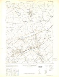
(27)- 1942 Map of Norristown
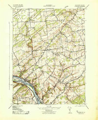
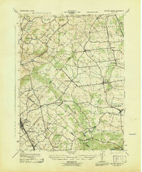
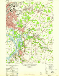
 1942 Norristown1942 Print · USGSSoutheastern Pennsylvania at the onset of World War II shows a landscape of busy industrial river towns and expanding rail suburbs. Genealogists and historians can trace the early transit networks connecting Norristown, Doylestown, and the riverfront at New Hope.
 - 1942 Map of Burlington
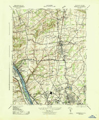
 1942 Burlington1942 Print · USGSThe Delaware River valley thrived at the start of the 1940s as a hub of heavy rail and river commerce. Genealogists and local historians can trace family-named sites and old transit points like Dunks Ferry, Borton Landing, and Neshaminy Falls.
 - 1943 Map of Bedminster
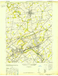
 1943 Bedminster1943 Print · USGSBucks County settlements and schoolhouses are captured here in the early 1940s as the rural landscape remained centered on local crossroads. Genealogists can locate family landmarks like Kulp's Corner, the Keller Glove Co, and the Deep Run School.
 - 1943 Map of Frenchtown
 1943 Frenchtown1943 Print · USGSThe Delaware River valley thrived as a rail and industrial corridor in the early 1940s. Genealogists can trace local roots through numerous landmarks like Frenchtown High School, Alexandria Cemetery, and Baptistown School.
 - 1943 Map of Quakertown
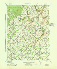
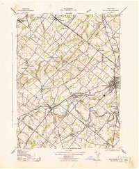
 1943 Quakertown1943 Print · USGSUpper Bucks County during the mid-1940s reveals a network of tight-knit villages and productive valley farms centered on the industrial borough of Quakertown. Genealogists and researchers can trace family lines through the streets of Perkasie, the small hamlets of Applebachsville and Shelly, or the crossroads at Loux Corner.
 - 1943 Map of Telford
 1943 Telford1943 Print · USGSBucks and Montgomery Counties are captured here during the mid-century, defined by the busy rail corridor connecting Souderton and Perkasie. Researchers can trace old township boundaries and find long-standing community sites like St Peters Ch, Line Lexington, and Menlo Park.
 - 1943 Map of Stockton
 1943 Stockton1943 Print · USGSHunterdon and Bucks counties are captured here in the early 1940s, highlighting the vital river-and-rail corridor along the New Jersey-Pennsylvania border. Researchers can trace old schoolhouses like Locktown School or locate industrial sites like the Stone Quarry and Delaware Canal.2 unique versions available
 - 1943 Map of Pennington
 1943 Pennington1943 Print · USGSThe Delaware River borderlands between New Jersey and Pennsylvania are captured here during the Second World War. Genealogists and historians can trace riverside landmarks like Scudders Falls, old family hamlets like Bear Tavern, and the early footprint of Mercer Airport.
 - 1943 Map of Doylestown
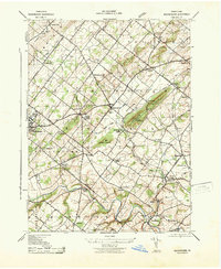
 1943 Doylestown1943 Print · USGSBucks County during the early 1940s reveals a settled landscape of crossroads hamlets and family-named landmarks connected by the Reading railroad. Researchers can trace ancestral roots through sites like Beulah Cemetery, the Farm School, and the Luth Ch Spire in Dublin.
 - 1943 Map of Buckingham
 1943 Buckingham1943 Print · USGSBucks County at the height of the Second World War reveals a landscape of tight-knit rural villages and essential rail connections. Genealogists and historians can trace family roots through landmarks like the Hughesian School, Mt Gilead Church, and stops along the Reading railroad.
 - 1943 Map of Milford Square
 1943 Milford Square1943 Print · USGSSoutheastern Pennsylvania's tri-county borderlands come to life in this mid-century survey. Genealogists can trace family roots through historic hamlets like Mumbauersville, Geryville, and the transit corridor of the Fogelsville Branch rail line.2 unique versions available
 - 1943 Map of Point Pleasant
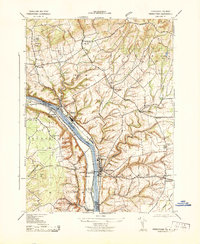
 1943 Point Pleasant1943 Print · USGSMid-century Bucks and Hunterdon counties come alive through this survey of the river valley during the war years. Researchers can trace the Canal Feeder and railroad lines that defined the Delaware River corridor, or locate family landmarks like the Menonite Cemetery and Reading School.
 - 1943 Map of Bethlehem
 1943 Bethlehem1943 Print · USGSNorthampton and Lehigh counties hummed with industry and river commerce during the early war years. Researchers can trace the path of the Lehigh Valley RR, locate family-named landmarks like Chief Tatamy, and find rural schools such as Mexico School and Poplar Valley Sch.
 - 1943 Map of Riegelsville
 1943 Riegelsville1943 Print · USGSThe Delaware River corridor comes alive in the early 1940s, highlighting the industrial and transport ties between eastern Pennsylvania and New Jersey. Genealogists and historians can trace the foundations of local industry at Durham Furnace or locate family roots near Durham Union Church and the Finesville School.
 - 1943 Map of Lambertville
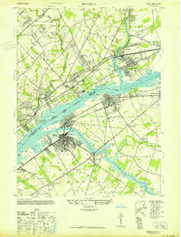
 1943 Lambertville1943 Print · USGSThe Delaware River valley at the height of the war years shows a landscape of busy canals, paper mills, and cross-river communities. Researchers can trace the industrial riverfront in Lambertville or locate family sites like the Thompson Memorial Cemetery and Fairfield School.
 - 1943 Map of Perkiomenville
 1943 Perkiomenville1943 Print · USGSThe Perkiomen Valley was a landscape of winding creeks and rail-stop villages during the early 1940s. Genealogists and local historians can trace family roots through settlements like Perkiomenville, Schwenksville, and Shirks Corner along the READING railroad line.
 - 1944 Map of Langhorne, 1947 Print
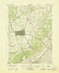
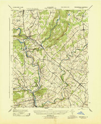
 1944 Langhorne1947 Print · USGSBucks County's suburban and industrial landscape comes into focus during the mid-1940s, showing a transition from rural farmland to settled boroughs. Genealogists can trace family connections through sites like George School, St Andrews Ch, and the many rail stops along the Reading Company line.
 - 1944 Map of Trenton West, 1950 Print
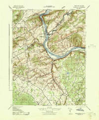
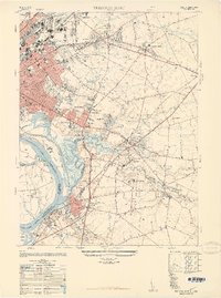
 1944 Trenton West1950 Print · USGSThe Delaware River corridor near Trenton and Morrisville is captured here at the height of its mid-century rail and industrial era. Genealogists and historians can trace old property boundaries and landmarks from Fallsington to the landmark Wm Trent House 1719.
 - 1944 Map of Newark, 1971 Print
 1944 Newark1971 Print · USGSThe industrial corridor from Philadelphia to New York was in a period of massive transition during the mid-forties. Genealogists and researchers can trace the rail lines of the Lehigh Valley RR, locate military installations like Picatinny Arsenal, and explore the early sprawl near Levittown.5 unique versions available
 - 1947 Map of Bristol
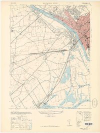
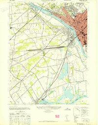
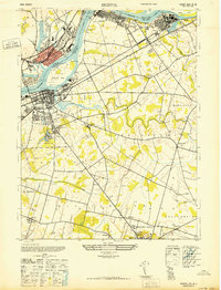 1947 Bristol1947 Print · USGSThe Delaware River shoreline at the close of the 1940s shows a landscape of industrial hubs and historic crossroads. Researchers can trace the layout of the Masonic Home, the settlement at Timbuctoo, and landmarks like the Stephan Grillet Sch.
 - 1947 Map of Trenton West
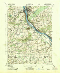
 1947 Trenton West1947 Print · USGSThe Delaware River corridor near Trenton and Morrisville was a hive of rail and river activity just after the war. Genealogists and local historians can trace the foundations of Fallsington, locate the Wm Trent House 1719, and follow the Reading Company line through Woodside.
 - 1947 Map of Trenton East
 1947 Trenton East1947 Print · USGSMercer County and the Delaware River waterfront are captured here just after the war as industrial hubs and suburban neighborhoods began to expand. Genealogists and historians can trace the foundations of Warner Village, locate the Bordentown Cemetery, or find the Pennsylvania Maritime Academy along the riverbank.
 - 1947 Map of Langhorne
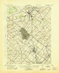
 1947 Langhorne1947 Print · USGSBucks County's suburban and industrial evolution is captured here in the years following the war. Researchers can trace the path of the Trenton Cut-Off, locate historic institutions like George School, or find the Silver Star Airport near Glenlake.
 - 1947 Map of Beverly
 1947 Beverly1947 Print · USGSThe Delaware River corridor was a hub of transit and industry in the late forties, connecting Pennsylvania and New Jersey via the Pennsylvania RR. Researchers can trace the footprints of institutional sites like the Philadelphia State Hospital or the St Elizabeth Convent.
 - 1948 Map of Trenton East, 1949 Print
 1948 Trenton East1949 Print · USGSMercer County and its surroundings are documented here in the late 1940s as suburban expansion began to reshape the landscape. Local historians can trace the development of Warner Village and Hamilton Square or locate landmarks like the Pennsylvania Maritime Academy and Bordentown Cemetery.
Showing maps 1-25 of 27
Top cities of Bucks County
- Bensalem Township historical maps
- Middletown Township historical maps
- Falls Township historical maps
- Warminster Township historical maps
- Lower Makefield Township historical maps
- Warrington Township historical maps
See more
Frequently asked questions
- What are the different types of historical maps available for Bucks County?
- What is the oldest map of Bucks County?
- Where can I purchase historical maps of Bucks County for my home or office?
- Where can I download high-res historical maps of Bucks County?
- Are there historical topographic maps available for Bucks County?
- Is there historical aerial imagery available for Bucks County?
- Where are historical maps of Bucks County sourced from?