Old Maps of Bucks County, Pennsylvania for Metal Detecting
Plan your next treasure hunt with 167 historic maps of Bucks County. Find old homesites, ghost towns, trails, and gathering spots that may be lost to time — perfect for identifying promising metal detecting locations.
- Locate forgotten sites: Uncover places like long-lost settlements, abandoned rail lines, or gathering spots.
- Plan better hunts: Use map overlays combined with LiDAR or satellite views to narrow in on historically rich areas.
- Made for detectorists: Thousands of hobbyists use these maps to discover relics, coins, and hidden history.
Use these historic maps to boost your research and find new opportunities beneath the surface of Bucks County.
Bucks County, PA maps
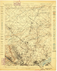
(167)- 1888 Map of Bordentown
 1888 Bordentown1888 Print · USGSCentral New Jersey in the 1880s was a bustling corridor of river commerce and intersecting rail lines. Genealogists and local historians can trace the early footprints of Bordentown, locate the junctions of the Pennsylvania Railroad, and find rural settlements like Recklesstown and Arneytown.
 - 1888 Map of Quakertown, 1963 Print
 1888 Quakertown1963 Print · USGSBucks and Montgomery counties are shown in high detail during the railroad era, when rural life centered on mill streams and village junctions. Genealogists can trace family roots through settlements like Richlandtown, Dillingersville, and the transit hub at Rocky Ridge Sta.
 - 1890 Map of Easton
 1890 Easton1890 Print · USGSThe Delaware River valley thrived as a transport hub during the 1890s, where three major canals and multiple railroads met at the Pennsylvania-New Jersey border. Genealogists and industrial historians can trace the paths of the Morris Canal, the works at Durham Furnace, and the strategic Musconetcong Tunnel.
 - 1890 Map of Lambertville
 1890 Lambertville1890 Print · USGSThe Delaware River valley thrived at the end of the nineteenth century as a hub for both canal and rail transport. Genealogists can trace family names and legacy sites near Lambertville, Washington's Crossing, and the junctions at Ringoes.
 - 1890 Map of Doylestown
 1890 Doylestown1890 Print · USGSBucks County in the late nineteenth century is captured here as a landscape of established mill towns and farming crossroads. Local historians can trace early rail routes like the Doylestown Branch and discover forgotten names such as New Galena, Griers Corner, and Hinkletown.
 - 1890 Map of Burlington
 1890 Burlington1890 Print · USGSThe Delaware River corridor was a thriving network of canal commerce and rail lines in the late nineteenth century. Genealogists and historians can trace family-named landings and early settlements like Dunks Ferry, Hulmeville, and the State Lunatic Asylum near Trenton.
 - 1890 Map of Quakertown
 1890 Quakertown1890 Print · USGSUpper Bucks and Montgomery counties are shown in the 1880s as a thriving corridor of rail towns and rural villages. Researchers can trace the original routes of the Perkasie and Sellersville settlements or locate family homesteads near Trumbauersville and Tylers Port.
 - 1891 Map of Easton
 1891 Easton1891 Print · USGSThe Delaware River valley thrived as a corridor of heavy industry and transit in the 1890s. Trace the path of historic waterways and early rail lines, including the Morris Canal, the ironworks at Durham Furnace, and rural crossroads like Still Valley.8 unique versions available
 - 1891 Map of Lambertville
 1891 Lambertville1891 Print · USGSThe Delaware River valley in the late 1880s is captured here at the height of the canal and rail era. Genealogists and historians can trace the early footprints of Lambertville, the course of the Delaware and Raritan Canal Feeder, and crossroads like Ringoes.
 - 1891 Map of Doylestown
 1891 Doylestown1891 Print · USGSBucks County and the Delaware River valley are captured in the late Victorian era as the region's agricultural and industrial patterns were firmly established. Genealogists and historians can trace old homestead locations near Kellers Church, identify stops along the Penna Railroad, and find riverside hamlets like Raven Rock and Tumble.11 unique versions available
 - 1893 Map of Germantown
 1893 Germantown1893 Print · USGSThe outskirts of Philadelphia and Montgomery County are shown in the late nineteenth century as rail lines transformed rural townships. Genealogists and historians can trace old property lines and depots from Warminster P.O. to the U.S. Arsenal.
 - 1893 Map of Bordentown
 1893 Bordentown1893 Print · USGSCentral New Jersey in the late nineteenth century was a bustling corridor of rail lines and established river towns. Genealogists and historians can trace the early footprints of Bordentown, Hamilton Square, and the various branches of the Pennsylvania Railroad.3 unique versions available
 - 1893 Map of Burlington
 1893 Burlington1893 Print · USGSThe Delaware River valley thrived as a corridor of rail and river commerce in the late nineteenth century. Genealogists and historians can trace defunct transport hubs like Dunks Ferry, explore the grounds of the State Lunatic Asylum, and locate old stops along the Philadelphia and Newtown Railroad.3 unique versions available
 - 1894 Map of Allentown
 1894 Allentown1894 Print · USGSThe Lehigh Valley's industrial heartland is caught in a moment of rapid Victorian-era growth along the river and canal corridor. Genealogists and local historians can trace the early footprints of Allentown and Nazareth, or locate vanished rail stops along the Lehigh Valley R.R. and Central R.R. of N.J.10 unique versions available
 - 1894 Map of Lambertville
 1894 Lambertville1894 Print · USGSThe Delaware River valley was a thriving hub of 19th-century commerce, where twin canals and the Belvidere Division railroad powered local industry. Researchers can trace ancestral lands through numerous family-named landmarks like Muirheads and Larison Corner, or locate the exact 1890s footprints of Lambertville and Hopewell.4 unique versions available
 - 1894 Map of Quakertown
 1894 Quakertown1894 Print · USGSSoutheast Pennsylvania at the close of the nineteenth century reveals a flourishing landscape of rail-linked villages and fertile creek valleys. Genealogists can trace family roots through dozens of named settlements like Trumbauersville, Zion Hill, and Applebachsville.9 unique versions available
 - 1894 Map of Germantown, 1961 Print
 1894 Germantown1961 Print · USGSThe northern Philadelphia suburbs and rural Montgomery County are captured here just as the railroad was transforming local life. Genealogists can trace family names and old property lines across Germantown, Hatboro, and the historic U.S. Arsenal.
 - 1896 Map of Germantown
 1896 Germantown1896 Print · USGSThe northern reaches of Philadelphia and lower Bucks County are shown in the late nineteenth century as rail lines transformed rural villages into bustling suburbs. Trace early transport routes along Street Road or locate family landmarks near Hatboro, Ambler, and the U. S. Arsenal.
 - 1899 Map of Germantown
 1899 Germantown1899 Print · USGSPhiladelphia and its northern townships are documented in the late nineteenth century as the suburban rail network expanded. Genealogists can trace family roots through historic settlements like Hatboro, Ambler, and the neighborhood of Chestnut Hill.9 unique versions available
 - 1904 Map of Burlington, 1958 Print
 1904 Burlington1958 Print · USGSThe Delaware River corridor thrives during the early twentieth century as a hub of rail, canal, and river commerce. Genealogists and local historians can trace family roots through riverside landings like Borton Landing or follow the legacy of institutions such as the George School and the State Lunatic Asylum.
 - 1906 Map of Lambertville
 1906 Lambertville1906 Print · USGSThe Delaware River valley in the early 1900s is shown in transition, where water-borne trade meets the expanding rail network. Genealogists and historians can trace family-named corners like Vanlieu Corners and Marshalls Corner alongside the Delaware and Raritan Canal.6 unique versions available
 - 1906 Map of Burlington
 1906 Burlington1906 Print · USGSThe Delaware River corridor was a bustling hub of rail and water transport in the early 1900s. Genealogists and local historians can trace the development of riverside wharves like Andalusia Wharf and institutional landmarks such as the State Lunatic Asylum.6 unique versions available
 - 1906 Map of Bordentown
 1906 Bordentown1906 Print · USGSThe Delaware River corridor and Burlington County interior are seen here in the early 1900s, showing a landscape shaped by rail and river commerce. Genealogists can trace early homesteads and hamlets near Bordentown, Hamilton Square, and the mills at Walnford.6 unique versions available
 - 1907 Map of Trenton
 1907 Trenton1907 Print · USGSThe Delaware River valley hums with turn-of-the-century industry and transport as river canals and railroads converge between New Jersey and Pennsylvania. Genealogists and local historians can trace the footprint of the George School, find early post offices like Holland PO, or locate old mill sites such as Blackwells Mills.4 unique versions available
 - 1918 Map of Camp Dix
 1918 Camp Dix1918 Print · USGSNew Jersey at the height of the Great War features the sprawling mobilization grounds of Camp Dix and its expansive Rifle Range. Genealogists and historians can trace defunct stops like Imlaystown Sta or locate family roots near New Egypt and Colliers Mill.2 unique versions available
Showing maps 1-25 of 167
Top cities of Bucks County
- Bensalem Township historical maps
- Middletown Township historical maps
- Falls Township historical maps
- Warminster Township historical maps
- Lower Makefield Township historical maps
- Warrington Township historical maps
See more
Frequently asked questions
- What are the different types of historical maps available for Bucks County?
- What is the oldest map of Bucks County?
- Where can I purchase historical maps of Bucks County for my home or office?
- Where can I download high-res historical maps of Bucks County?
- Are there historical topographic maps available for Bucks County?
- Is there historical aerial imagery available for Bucks County?
- Where are historical maps of Bucks County sourced from?