1990s Maps of Bristol Township, Pennsylvania
Explore 3 historic maps of Bristol Township from the 1990s. These maps offer a rare glimpse into what life looked like during the 1990s — showing old roads, neighborhoods, homes, and landmarks that have changed or disappeared over time.
Whether you're researching your family's past, planning a metal detecting trip, or studying how Bristol Township's landscape evolved across the 1990s, these high-resolution maps are a powerful tool for exploring the history of this region.
- Focus on a specific era: All maps on this page are from the 1990s, giving you a focused view of this time period.
- See what’s changed: Compare century-old streets, trails, and buildings to today's modern landscape using overlays and satellite layers.
- Research with precision: Use these maps for genealogy, historical research, land use analysis, or educational projects.
- View, download, or print: Maps are fully viewable online in high resolution, and can be downloaded or printed for your own records.
Start exploring Bristol Township's history through authentic maps from the 1990s. This is your window into the past.
Bristol Township, PA maps
(3)- 1993 Map of Langhorne, 1998 Print
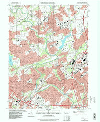 1993 Langhorne1998 Print · USGSBucks County's suburban expansion is fully visible in the 1990s as modern highways weave through historic boroughs and campus grounds. Genealogists can locate family sites at King David Cemetery or Greenwood Cem while tracing the growth of Langhorne and Levittown.
 - 1995 Map of Trenton West, 1998 Print
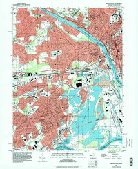 1995 Trenton West1998 Print · USGSThe Delaware River corridor between Trenton and Levittown is captured here in the mid-nineties, showing decades of suburban and industrial evolution. Trace local family history through Riverview Cemetery, St Andrews Ch, and the many schools like William Penn High Sch.
 - 1995 Map of Beverly, 2000 Print
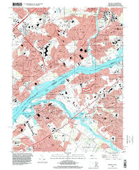 1995 Beverly2000 Print · USGSCrossing the Delaware during the mid-1990s reveals a suburban landscape still deeply shaped by its riverfront heritage and industrial rail corridors. Genealogists can trace family sites from Beverly National Cemetery to the Philadelphia State Hospital or the historic Byberry Chapel.
End of results
Showing maps 1-3 of 3
Top cities near Bristol Township
- Philadelphia historical maps
- Hamilton Township historical maps
- Trenton historical maps
- Camden historical maps
- Cherry Hill Township historical maps
- Bensalem Township historical maps
See more
Top neighborhoods of Bristol Township
- Fergusonville historical maps
- Belardy historical maps
- Maple Shade historical maps
- Rockdale historical maps
- Upper Emilie historical maps
- Goldenridge historical maps
See more
Frequently asked questions
- What are the different types of historical maps available for Bristol Township?
- What is the oldest map of Bristol Township?
- Where can I purchase historical maps of Bristol Township for my home or office?
- Where can I download high-res historical maps of Bristol Township?
- Are there historical topographic maps available for Bristol Township?
- Is there historical aerial imagery available for Bristol Township?
- Where are historical maps of Bristol Township sourced from?