1960s Maps of Allegheny Township, Pennsylvania
Explore 4 historic maps of Allegheny Township from the 1960s. These maps offer a rare glimpse into what life looked like during the 1960s — showing old roads, neighborhoods, homes, and landmarks that have changed or disappeared over time.
Whether you're researching your family's past, planning a metal detecting trip, or studying how Allegheny Township's landscape evolved across the 1960s, these high-resolution maps are a powerful tool for exploring the history of this region.
- Focus on a specific era: All maps on this page are from the 1960s, giving you a focused view of this time period.
- See what’s changed: Compare century-old streets, trails, and buildings to today's modern landscape using overlays and satellite layers.
- Research with precision: Use these maps for genealogy, historical research, land use analysis, or educational projects.
- View, download, or print: Maps are fully viewable online in high resolution, and can be downloaded or printed for your own records.
Start exploring Allegheny Township's history through authentic maps from the 1960s. This is your window into the past.
Allegheny Township, PA maps
(4)- 1963 Map of Hilliards, 1965 Print
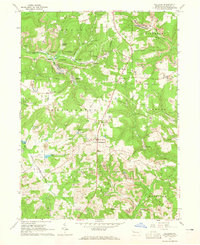 1963 Hilliards1965 Print · USGSButler County's northern townships are shown in the early sixties as a landscape defined by industry and rural tradition. Researchers can trace the footprint of numerous strip mines and oil wells near settlements like Hilliards, Argentine, and Annisville.4 unique versions available
 - 1963 Map of Parker, 1965 Print
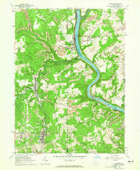 1963 Parker1965 Print · USGSThe river-and-rail corridor of northern Armstrong and Butler counties is captured here in the early sixties, showing an active landscape of energy extraction. Genealogists and historians can locate family landmarks such as Bear Creek Cemetery or Griswell Ch and trace the rail path through Petrolia and Bruin.5 unique versions available
 - 1963 Map of Emlenton, 1965 Print
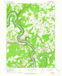 1963 Emlenton1965 Print · USGSThe Allegheny and Clarion rivers converge in the early 1960s, creating a hub of rail activity and resource extraction. Genealogists and historians can trace the numerous oil wells and strip mines surrounding communities like St Petersburg, Emlenton, and Foxburg.4 unique versions available
 - 1963 Map of Eau Claire, 1965 Print
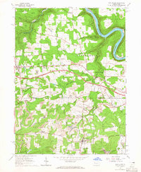 1963 Eau Claire1965 Print · USGSThe northern reaches of Butler and Venango Counties are captured here in the early sixties, showing a landscape defined by fossil fuel extraction. Genealogists can locate family-named settlements like Riddle Crossroads, landmarks such as the Anderson Stone House, and the Eau Claire Cemetery.5 unique versions available
End of results
Showing maps 1-4 of 4
Top cities near Allegheny Township
- Cranberry Township historical maps
- Monroe historical maps
- Rockland Township historical maps
- Toby Township historical maps
- Knox historical maps
- East Brady historical maps
See more
Top neighborhoods of Allegheny Township
- Sedwicks Mill historical maps
- Six Points historical maps
- Sandy Point historical maps
- Bonus historical maps
Frequently asked questions
- What are the different types of historical maps available for Allegheny Township?
- What is the oldest map of Allegheny Township?
- Where can I purchase historical maps of Allegheny Township for my home or office?
- Where can I download high-res historical maps of Allegheny Township?
- Are there historical topographic maps available for Allegheny Township?
- Is there historical aerial imagery available for Allegheny Township?
- Where are historical maps of Allegheny Township sourced from?