1960s Maps of Franklin Township, Pennsylvania
Explore 4 historic maps of Franklin Township from the 1960s. These maps offer a rare glimpse into what life looked like during the 1960s — showing old roads, neighborhoods, homes, and landmarks that have changed or disappeared over time.
Whether you're researching your family's past, planning a metal detecting trip, or studying how Franklin Township's landscape evolved across the 1960s, these high-resolution maps are a powerful tool for exploring the history of this region.
- Focus on a specific era: All maps on this page are from the 1960s, giving you a focused view of this time period.
- See what’s changed: Compare century-old streets, trails, and buildings to today's modern landscape using overlays and satellite layers.
- Research with precision: Use these maps for genealogy, historical research, land use analysis, or educational projects.
- View, download, or print: Maps are fully viewable online in high resolution, and can be downloaded or printed for your own records.
Start exploring Franklin Township's history through authentic maps from the 1960s. This is your window into the past.
Franklin Township, PA maps
(4)- 1961 Map of Prospect, 1964 Print
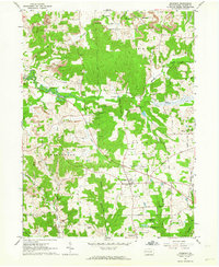 1961 Prospect1964 Print · USGSButler County's rural landscape is captured in the early sixties as industrial mining and traditional farming intersect near Prospect. Genealogists and historians can locate family landmarks like Crown Hill Cem, Bunker Hill Sch, and the Carnahan Airport.3 unique versions available
 - 1962 Map of Canton
 1962 Canton1962 Print · USGSThe industrial heartland of Eastern Ohio and Western Pennsylvania thrives in the early sixties as steel mills and rail lines dominate the river valleys. Genealogists and historians can trace local landmarks like McKinley National Memorial, Malone College, and industrial sites such as Republic Steel Corp.2 unique versions available
 - 1964 Map of Pittsburgh
 1964 Pittsburgh1964 Print · USGSWestern Pennsylvania in the late fifties and early sixties shows a landscape of powerful river industries and expanding highways. Genealogists and historians can trace the rail corridors of the Pennsylvania RR through industrial hubs like Johnstown, Altoona, and Nanty Glo.
 - 1964 Map of Mount Chestnut, 1965 Print
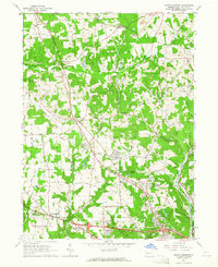 1964 Mount Chestnut1965 Print · USGSButler County's hills were undergoing a mid-century shift during the 1960s as new subdivisions and highways began to border traditional rail junctions. Researchers can trace family roots at Mount Chestnut Cem or locate community hubs like Unionville and the Drive-in Theater.4 unique versions available
End of results
Showing maps 1-4 of 4
Top cities near Franklin Township
- Cranberry Township historical maps
- Butler historical maps
- Grove City historical maps
- Zelienople historical maps
- Slippery Rock historical maps
- Clinton Township historical maps
See more
Top neighborhoods of Franklin Township
Frequently asked questions
- What are the different types of historical maps available for Franklin Township?
- What is the oldest map of Franklin Township?
- Where can I purchase historical maps of Franklin Township for my home or office?
- Where can I download high-res historical maps of Franklin Township?
- Are there historical topographic maps available for Franklin Township?
- Is there historical aerial imagery available for Franklin Township?
- Where are historical maps of Franklin Township sourced from?