1960s Maps of Croyle Township, Pennsylvania
Explore 5 historic maps of Croyle Township from the 1960s. These maps offer a rare glimpse into what life looked like during the 1960s — showing old roads, neighborhoods, homes, and landmarks that have changed or disappeared over time.
Whether you're researching your family's past, planning a metal detecting trip, or studying how Croyle Township's landscape evolved across the 1960s, these high-resolution maps are a powerful tool for exploring the history of this region.
- Focus on a specific era: All maps on this page are from the 1960s, giving you a focused view of this time period.
- See what’s changed: Compare century-old streets, trails, and buildings to today's modern landscape using overlays and satellite layers.
- Research with precision: Use these maps for genealogy, historical research, land use analysis, or educational projects.
- View, download, or print: Maps are fully viewable online in high resolution, and can be downloaded or printed for your own records.
Start exploring Croyle Township's history through authentic maps from the 1960s. This is your window into the past.
Croyle Township, PA maps
(5)- 1963 Map of Ebensburg, 1965 Print
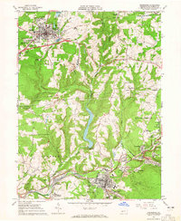 1963 Ebensburg1965 Print · USGSEbensburg and the surrounding coal towns of Cambria County are captured in the early sixties during a period of industrial transition. Researchers can trace family roots through numerous local churches and cemeteries, or locate defunct industrial sites like Miller Shaft and Plane Bank along the PENNSYLVANIA railroad.5 unique versions available
 - 1963 Map of Beaverdale, 1965 Print
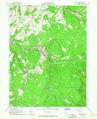 1963 Beaverdale1965 Print · USGSCoal mining and rail transport shaped these Cambria County valleys in the early 1960s. Researchers can trace family ties at Sherbine Cem, locate the old Buckhorn Grange, or study the footprint of towns like Beaverdale and Dunlo during their industrial peak.4 unique versions available
 - 1964 Map of Pittsburgh
 1964 Pittsburgh1964 Print · USGSWestern Pennsylvania in the late fifties and early sixties shows a landscape of powerful river industries and expanding highways. Genealogists and historians can trace the rail corridors of the Pennsylvania RR through industrial hubs like Johnstown, Altoona, and Nanty Glo.
 - 1964 Map of Geistown, 1965 Print
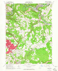 1964 Geistown1965 Print · USGSCambria County in the mid-sixties reveals an industrial landscape defined by river-valley mining and growing suburban centers. Genealogists can trace family names through local landmarks like St Anthony Cem, Sidman (Lovett Sta), and Locust Grove Ch.5 unique versions available
 - 1964 Map of Nanty Glo, 1966 Print
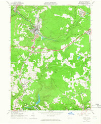 1964 Nanty Glo1966 Print · USGSCambria County's industrial heart is captured in the mid-1960s, showing the intersection of mining, rail, and community life. Genealogists and historians can locate family landmarks like St Marys Cem and trace the paths of the Pennsylvania Railroad through Nanty Glo and Summerhill.4 unique versions available
End of results
Showing maps 1-5 of 5
Top cities near Croyle Township
- Johnstown historical maps
- Franklin historical maps
- Westmont historical maps
- Windber historical maps
- Ebensburg historical maps
- Stonycreek Township historical maps
See more
Top neighborhoods of Croyle Township
- Fishertown historical maps
- Rockville historical maps
- New Germany historical maps
- Soukesburg historical maps
Frequently asked questions
- What are the different types of historical maps available for Croyle Township?
- What is the oldest map of Croyle Township?
- Where can I purchase historical maps of Croyle Township for my home or office?
- Where can I download high-res historical maps of Croyle Township?
- Are there historical topographic maps available for Croyle Township?
- Is there historical aerial imagery available for Croyle Township?
- Where are historical maps of Croyle Township sourced from?