1950s Maps of Cameron County, Pennsylvania
Explore 10 historic maps of Cameron County from the 1950s. These maps offer a rare glimpse into what life looked like during the 1950s — showing old roads, neighborhoods, homes, and landmarks that have changed or disappeared over time.
Whether you're researching your family's past, planning a metal detecting trip, or studying how Cameron County's landscape evolved across the 1950s, these high-resolution maps are a powerful tool for exploring the history of this region.
- Focus on a specific era: All maps on this page are from the 1950s, giving you a focused view of this time period.
- See what’s changed: Compare century-old streets, trails, and buildings to today's modern landscape using overlays and satellite layers.
- Research with precision: Use these maps for genealogy, historical research, land use analysis, or educational projects.
- View, download, or print: Maps are fully viewable online in high resolution, and can be downloaded or printed for your own records.
Start exploring Cameron County's history through authentic maps from the 1950s. This is your window into the past.
Cameron County, PA maps
(10)- 1950 Map of Rich Valley
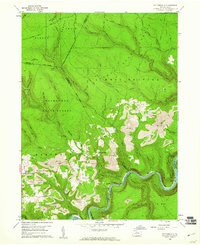
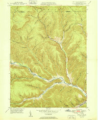 1950 Rich Valley1950 Print · USGSCameron and McKean counties in the early postwar era are defined by the steep hollows of the Pennsylvania Wilds. Genealogists can trace family names and small-town footprints at Lockwood, Weber City, and the North Creek Chapel.2 unique versions available
 - 1950 Map of Wharton
 1950 Wharton1950 Print · USGSPotter County's deep-cut valleys and river confluences are captured here in the post-war era. Genealogists and historians can locate remote family landmarks like Reesville Sch, the Splash Dam on Bailey Run, and the burial grounds at Forest Hill Cem.2 unique versions available
 - 1950 Map of Emporium
 1950 Emporium1950 Print · USGSEmporium and the Sinnemahoning Creek valleys are captured here at mid-century, as the region's railroad era and timbering history met new state park conservation. Researchers can trace family plots at Newton Cem, old rail stops at Gardeau, and local paths like the Pine Camp Trail.
 - 1950 Map of Wildwood Fire Tower
 1950 Wildwood Fire Tower1950 Print · USGSThe Elk and McKean county line runs through this mid-century survey of the Pennsylvania highlands, featuring rugged drainage networks and early timbering hubs. Genealogists can trace family-named hollows and sites like Wellendorf Station, Dead Mans Lick, and Wildwood Fire Tower.2 unique versions available
 - 1954 Map of Williamsport
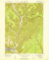
 1954 Williamsport1954 Print · USGSNorth-central Pennsylvania in the mid-fifties is defined by the winding West Branch Susquehanna River and its industrial valley. Local historians can trace the massive Susquehanna Ordnance Depot and the extensive rail networks of the Pennsylvania Railroad.
 - 1957 Map of Warren, 1964 Print
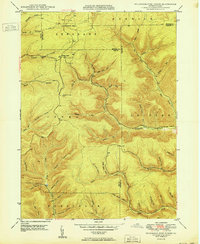
 1957 Warren1964 Print · USGSThe northern Pennsylvania oil and timber country comes into focus in the mid-fifties, showing the region before modern highway expansions. Trace the industrial rail networks of the Pennsylvania RR and the early Allegheny River Reservoir near Warren and Oil City.4 unique versions available
 - 1958 Map of Warren
 1958 Warren1958 Print · USGSNorthern Pennsylvania’s timber and oil country is captured here during the late fifties, showing the interplay of industrial valleys and vast state forests. Genealogists can trace family connections across the Cornplanter Indian Reservation or through rail hubs like Oil City and Saint Marys.
 - 1959 Map of Warren
 1959 Warren1959 Print · USGSNorthern Pennsylvania's oil and timber country comes alive in this late-fifties study of the forest-clad plateaus. Trace the historic Cornplanter (Indian Reservation), the sprawling Oil Field, and the rail lines of the Pennsylvania RR.2 unique versions available
 - 1959 Map of Devils Elbow, 1960 Print
 1959 Devils Elbow1960 Print · USGSThe high plateau of Clearfield and Cameron Counties is shown here in the late fifties, dominated by the timberlands of the Moshannon State Forest. Genealogists and outdoorsmen can trace the rugged topography near Quehanna, locating isolated landmarks like the Lookout Tower and Arnold Mtn.4 unique versions available
 - 1959 Map of Pottersdale, 1961 Print
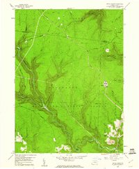
 1959 Pottersdale1961 Print · USGSThe northern Pennsylvania coal and timber country is captured here during the late fifties, showing the industrial interface between state forests and coal extraction. Genealogists and historians can locate Oak Hill Ch, trace the New York Central along the river, and find rural settlements like Pottersdale and Belford.4 unique versions available
End of results
Showing maps 1-10 of 10
Top cities of Cameron County
Frequently asked questions
- What are the different types of historical maps available for Cameron County?
- What is the oldest map of Cameron County?
- Where can I purchase historical maps of Cameron County for my home or office?
- Where can I download high-res historical maps of Cameron County?
- Are there historical topographic maps available for Cameron County?
- Is there historical aerial imagery available for Cameron County?
- Where are historical maps of Cameron County sourced from?