1990s Maps of Cameron County, Pennsylvania
Explore 3 historic maps of Cameron County from the 1990s. These maps offer a rare glimpse into what life looked like during the 1990s — showing old roads, neighborhoods, homes, and landmarks that have changed or disappeared over time.
Whether you're researching your family's past, planning a metal detecting trip, or studying how Cameron County's landscape evolved across the 1990s, these high-resolution maps are a powerful tool for exploring the history of this region.
- Focus on a specific era: All maps on this page are from the 1990s, giving you a focused view of this time period.
- See what’s changed: Compare century-old streets, trails, and buildings to today's modern landscape using overlays and satellite layers.
- Research with precision: Use these maps for genealogy, historical research, land use analysis, or educational projects.
- View, download, or print: Maps are fully viewable online in high resolution, and can be downloaded or printed for your own records.
Start exploring Cameron County's history through authentic maps from the 1990s. This is your window into the past.
Cameron County, PA maps
(3)- 1994 Map of Emporium, 1999 Print
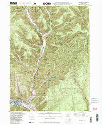 1994 Emporium1999 Print · USGSEmporium and the surrounding northern Pennsylvania highlands appear here at a time when the region's vast state forests and parks had fully matured. Genealogists and hikers can trace family names in Newton Cem or explore the rugged drainage of Sinnemahoning Creek via the Mc Dowell Trail.2 unique versions available
 - 1994 Map of Hammersley Fork, 1999 Print
 1994 Hammersley Fork1999 Print · USGSClinton and Potter Counties are shown here in the 1990s, dominated by the winding valley of Kettle Creek. Genealogists and local historians can locate Hammersley Fork, trace the grounds of Summerson Cem, or find the former Central Sch.
 - 1994 Map of Wharton, 1999 Print
 1994 Wharton1999 Print · USGSThe First Fork Sinnemahoning valley in Potter County remained a heartland of state forestry and small river settlements in the late twentieth century. Genealogists can locate family landmarks such as Wharton Cem, Rees Cem, and the old Reesville Sch site.
End of results
Showing maps 1-3 of 3
Top cities of Cameron County
Frequently asked questions
- What are the different types of historical maps available for Cameron County?
- What is the oldest map of Cameron County?
- Where can I purchase historical maps of Cameron County for my home or office?
- Where can I download high-res historical maps of Cameron County?
- Are there historical topographic maps available for Cameron County?
- Is there historical aerial imagery available for Cameron County?
- Where are historical maps of Cameron County sourced from?