1990s Maps of East Penn Township, Pennsylvania
Explore 7 historic maps of East Penn Township from the 1990s. These maps offer a rare glimpse into what life looked like during the 1990s — showing old roads, neighborhoods, homes, and landmarks that have changed or disappeared over time.
Whether you're researching your family's past, planning a metal detecting trip, or studying how East Penn Township's landscape evolved across the 1990s, these high-resolution maps are a powerful tool for exploring the history of this region.
- Focus on a specific era: All maps on this page are from the 1990s, giving you a focused view of this time period.
- See what’s changed: Compare century-old streets, trails, and buildings to today's modern landscape using overlays and satellite layers.
- Research with precision: Use these maps for genealogy, historical research, land use analysis, or educational projects.
- View, download, or print: Maps are fully viewable online in high resolution, and can be downloaded or printed for your own records.
Start exploring East Penn Township's history through authentic maps from the 1990s. This is your window into the past.
East Penn Township, PA maps
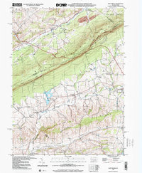
(7)- 1992 Map of Lehighton, 1995 Print
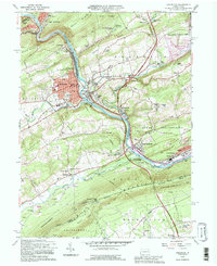 1992 Lehighton1995 Print · USGSThe Lehigh Valley industrial corridor is captured here in the early 1990s, where the river meets the steep ridges of Carbon County. Researchers can trace the legacy of the Packerton Yards, locate ancestral sites like Slatedale Cem, or follow the Appalachian Trail along Blue Mountain.
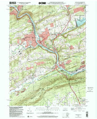
 - 1997 Map of Lehighton, 1998 Print
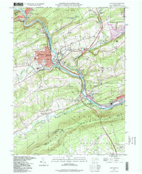 1997 Lehighton1998 Print · USGSCarbon County industrial and river life are captured here in the late twentieth century as the rail lines navigate the narrow Lehigh gap. Genealogists and hikers can trace the Appalachian Trail along the ridge or locate family sites at Packerton Cem and St Peters Ch.
 - 1997 Map of Palmerton, 1999 Print
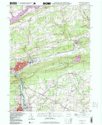 1997 Palmerton1999 Print · USGSThe industrial corridor of the Lehigh Valley meets the ridgeline of the Appalachians in the late nineties. Researchers can trace the legacy of the Lehigh Canal and identify local landmarks like the Drive-in Theater, Bethany Tabernacle, and Slatington Airport.
 - 1997 Map of Nesquehoning, 1999 Print
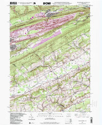 1997 Nesquehoning1999 Print · USGSThe anthracite coal region and the Mahoning Valley meet in this late-century study of Carbon and Schuylkill Counties. Genealogists can trace family roots through Our Lady of Mt Carmel Cem or search for old school sites like Sanden Sch and Ginders Sch.
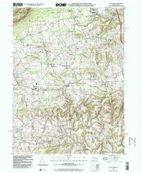
 - 1999 Map of New Tripoli, 2001 Print
 1999 New Tripoli2001 Print · USGSLehigh and Schuylkill counties are captured here at the close of the twentieth century as rural landscapes met conservation efforts. Trace local genealogy and infrastructure through New Jerusalem Ch, Ulrichs Bridge, and the Appalachian Scenic Trail.
 - 1999 Map of Lehighton, 2001 Print
 1999 Lehighton2001 Print · USGSThe Lehigh River valley at the close of the twentieth century shows a landscape defined by industrial heritage and modern recreation. Genealogists and historians can trace rail lines through Lizard Creek Junction or locate family sites at Packerton Cem and North Weissport.
 - 1999 Map of Slatedale, 2002 Print
 1999 Slatedale2002 Print · USGSLehigh County township life at the end of the century is defined by rural crossroads and the ridge of Blue Mountain. Genealogists and local historians can trace family locations near Heidelberg Ch, Millers Cem, or the early settlements of Lehigh Furnace and Slatedale.
End of results
Showing maps 1-7 of 7
Top cities near East Penn Township
- Allentown historical maps
- Northampton historical maps
- Maxatawny Township historical maps
- Tamaqua historical maps
- Palmerton historical maps
- Lehighton historical maps
See more
Top neighborhoods of East Penn Township
- Germans historical maps
- Balliet historical maps
- Kittatinny historical maps
- West Bowmans historical maps
- Ashfield historical maps
Frequently asked questions
- What are the different types of historical maps available for East Penn Township?
- What is the oldest map of East Penn Township?
- Where can I purchase historical maps of East Penn Township for my home or office?
- Where can I download high-res historical maps of East Penn Township?
- Are there historical topographic maps available for East Penn Township?
- Is there historical aerial imagery available for East Penn Township?
- Where are historical maps of East Penn Township sourced from?