Old Maps of Port Matilda, Pennsylvania
Explore 16 old maps of Port Matilda, spanning from 1922 to today. These high-resolution historic maps reveal how streets, neighborhoods, landmarks, and natural features evolved over time — perfect for genealogy, metal detecting, research, and local history exploration.
What you can do with these maps:
- See how Port Matilda changed over time: Compare historical maps to modern-day views to trace roads, homesites, rail lines & more.
- View detailed metadata: Each map includes creators, publishers, year, scale, and archive source.
- Overlay maps with satellite & LiDAR: Visualize the past alongside modern tools to explore terrain & human change.
- Trusted historical sources: Maps sourced from the USGS, Library of Congress, and other archives.
- Access maps your way: View online, download high-res files, or order prints for personal or research use.
Start exploring old maps of Port Matilda to uncover forgotten places, hidden landmarks, and the deep history beneath your feet.
Port Matilda, PA maps
(16)- 1922 Map of Philipsburg
 1922 Philipsburg1922 Print · USGSPhilipsburg and the northern Allegheny coalfields are captured here in the early twenties during a period of heavy rail and mining activity. Genealogists can trace family locations through dozens of named rural schoolhouses like Klondike School and industrial sites including Cuba Mines and the Central RR of Pennsylvania.3 unique versions available
 - 1939 Map of Philipsburg, 1955 Print
 1939 Philipsburg1955 Print · USGSCentral Pennsylvania’s coal and iron country is captured here during the late thirties, showing the rail-linked settlements of the Moshannon Valley. Researchers can trace family roots at Black Oak Sch, find old industrial sites like Martha Furnace, or locate the Rusnak Mine.2 unique versions available
 - 1945 Map of Philipsburg
 1945 Philipsburg1945 Print · USGSPhilipsburg and the central Pennsylvania coal country are shown here in the mid-1940s as industry and recreation shaped the landscape. Researchers can trace the legacy of the NEW YORK CENTRAL railroad, find the site of Martha Furnace, or locate rural schools like Hope Sch and Black Oak Sch.
 - 1953 Map of Pittsburgh
 1953 Pittsburgh1953 Print · USGSWestern Pennsylvania's industrial landscape at the start of the fifties shows the steel and rail corridors between Pittsburgh and Altoona. Trace family roots in river towns like Tarentum or follow the Pennsylvania Turnpike across Laurel Hill.
 - 1954 Map of Pittsburgh
 1954 Pittsburgh1954 Print · USGSWestern Pennsylvania in the early fifties remains a powerhouse of heavy industry and vital transit corridors. Genealogists and historians can trace the rail-and-river network connecting Pittsburgh, Johnstown, and Altoona via the Pennsylvania RR and the Lincoln Highway.2 unique versions available
 - 1958 Map of Pittsburgh
 1958 Pittsburgh1958 Print · USGSWestern Pennsylvania in the late fifties shows an industrial heartland defined by the confluence of the Allegheny River and Monongahela River. Researchers can trace the sprawling rail networks of the Pennsylvania RR and find established towns like Butler, Latrobe, and Windber.5 unique versions available
 - 1959 Map of Pittsburgh
 1959 Pittsburgh1959 Print · USGSWestern Pennsylvania in the late fifties is captured here at the height of its industrial era. Genealogists and historians can trace the riverfront growth of Pittsburgh, the rail works at Altoona, and the mountain gaps of Laurel Hill.
 - 1959 Map of Port Matilda, 1960 Print
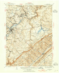
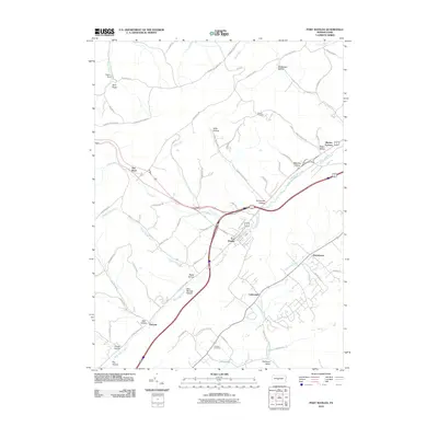
 1959 Port Matilda1960 Print · USGSPort Matilda and the Bald Eagle Creek valley are captured here in the late fifties, showing a landscape defined by the railroad and mountain gaps. Trace family history at Blackoak Ch or explore the old industrial site at Martha Furnace.4 unique versions available
 - 1964 Map of Pittsburgh
 1964 Pittsburgh1964 Print · USGSWestern Pennsylvania in the late fifties and early sixties shows a landscape of powerful river industries and expanding highways. Genealogists and historians can trace the rail corridors of the Pennsylvania RR through industrial hubs like Johnstown, Altoona, and Nanty Glo.
 - 1984 Map of Tyrone, 1985 Print
 1984 Tyrone1985 Print · USGSCentral Pennsylvania in the mid-eighties shows a rugged landscape defined by the industry of Altoona and the ridges of the Appalachians. Genealogists and historians can trace the rail corridors of CONRAIL and locate vanished family homes near Glendale Lake or within Sinking Valley.
 - 1994 Map of Port Matilda, 1997 Print
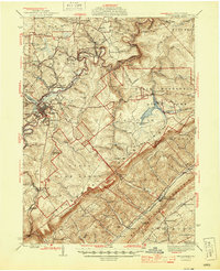
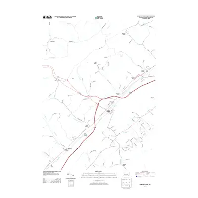
 1994 Port Matilda1997 Print · USGSPort Matilda and the Bald Eagle Valley are shown here in the mid-1990s, capturing the interface between deep state forests and valley settlements. Researchers can trace family sites at Martha Furnace, Stormstown, and the Brown Cem near the mountain ridge.
 - 2010 Map of Port Matilda, 2010 Print
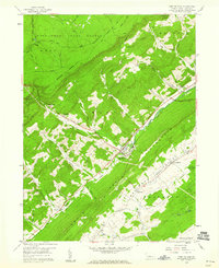
 2010 Port Matilda2010 Print · USGSCovers Port Matilda, including Rush Township, Martha Furnace, and other nearby areas
 - 2013 Map of Port Matilda, 2013 Print
 2013 Port Matilda2013 Print · USGSCovers Port Matilda, including Rush Township, Martha Furnace, and other nearby areas
 - 2016 Map of Port Matilda, 2016 Print
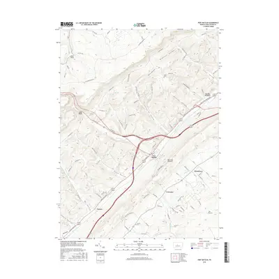 2016 Port Matilda2016 Print · USGSCovers Port Matilda, including Rush Township, Martha Furnace, and other nearby areas
 - 2019 Map of Port Matilda, 2019 Print
 2019 Port Matilda2019 Print · USGSCovers Port Matilda, including Rush Township, Martha Furnace, and other nearby areas
 - 2023 Map of Port Matilda, 2023 Print
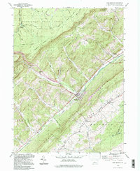
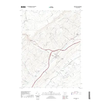
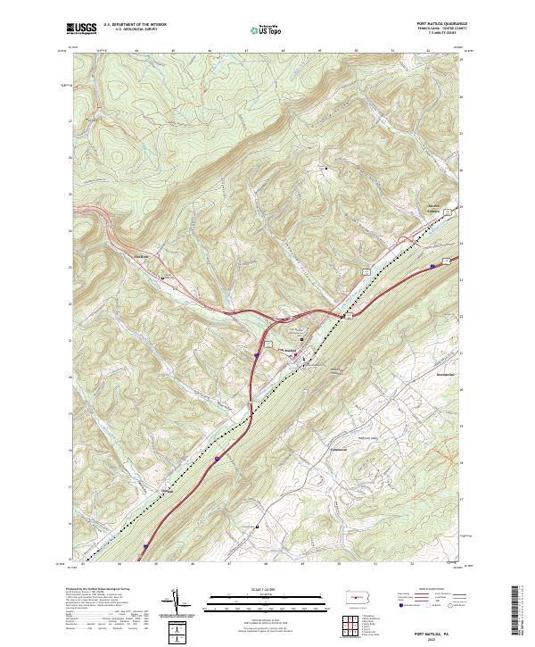 2023 Port Matilda2023 Print · USGSPort Matilda and the Bald Eagle Valley are shown here in the early twenty-first century, anchored by the intersection of major ridge-following highways. Researchers can trace family sites at Martha Furnace, Black Oak Cem, and Friends Cem.
End of results
Showing maps 1-16 of 16
Top cities near Port Matilda
- State College historical maps
- Tyrone historical maps
- Philipsburg historical maps
- Menno Township historical maps
- Houserville historical maps
- Warriors Mark Township historical maps
See more
Frequently asked questions
- What are the different types of historical maps available for Port Matilda?
- What is the oldest map of Port Matilda?
- Where can I purchase historical maps of Port Matilda for my home or office?
- Where can I download high-res historical maps of Port Matilda?
- Are there historical topographic maps available for Port Matilda?
- Is there historical aerial imagery available for Port Matilda?
- Where are historical maps of Port Matilda sourced from?