Old Maps of Glass City, Rush Township for Academic Research
Study the evolution of Glass City with these high-resolution historic maps. Whether you're teaching, researching, or modeling changes in land use, these maps provide essential visual documentation of urban, environmental, and geographic change.
- Analyze long-term change: Track patterns in development, transportation, and natural features.
- Ideal for environmental or urban studies: Support academic projects with primary historical map data.
- Use in the classroom or lab: Educators and researchers rely on these maps to bring historical context to life.
These maps are a powerful tool for teaching, research, and visualizing how Glass City has changed over the decades.
Glass City, Rush Township maps
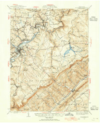
- 1922 Map of Philipsburg
 1922 Philipsburg1922 Print · USGSPhilipsburg and the northern Allegheny coalfields are captured here in the early twenties during a period of heavy rail and mining activity. Genealogists can trace family locations through dozens of named rural schoolhouses like Klondike School and industrial sites including Cuba Mines and the Central RR of Pennsylvania.3 unique versions available
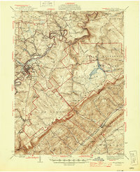
 - 1939 Map of Philipsburg, 1955 Print
 1939 Philipsburg1955 Print · USGSCentral Pennsylvania’s coal and iron country is captured here during the late thirties, showing the rail-linked settlements of the Moshannon Valley. Researchers can trace family roots at Black Oak Sch, find old industrial sites like Martha Furnace, or locate the Rusnak Mine.2 unique versions available
 - 1945 Map of Philipsburg
 1945 Philipsburg1945 Print · USGSPhilipsburg and the central Pennsylvania coal country are shown here in the mid-1940s as industry and recreation shaped the landscape. Researchers can trace the legacy of the NEW YORK CENTRAL railroad, find the site of Martha Furnace, or locate rural schools like Hope Sch and Black Oak Sch.
 - 1953 Map of Pittsburgh
 1953 Pittsburgh1953 Print · USGSWestern Pennsylvania's industrial landscape at the start of the fifties shows the steel and rail corridors between Pittsburgh and Altoona. Trace family roots in river towns like Tarentum or follow the Pennsylvania Turnpike across Laurel Hill.
 - 1954 Map of Pittsburgh
 1954 Pittsburgh1954 Print · USGSWestern Pennsylvania in the early fifties remains a powerhouse of heavy industry and vital transit corridors. Genealogists and historians can trace the rail-and-river network connecting Pittsburgh, Johnstown, and Altoona via the Pennsylvania RR and the Lincoln Highway.2 unique versions available
 - 1958 Map of Pittsburgh
 1958 Pittsburgh1958 Print · USGSWestern Pennsylvania in the late fifties shows an industrial heartland defined by the confluence of the Allegheny River and Monongahela River. Researchers can trace the sprawling rail networks of the Pennsylvania RR and find established towns like Butler, Latrobe, and Windber.5 unique versions available
 - 1958 Map of Sandy Ridge, 1960 Print
 1958 Sandy Ridge1960 Print · USGSIn the late 1950s, the high country of the Allegheny Front is a mix of state conservation lands and active coal mining. Genealogists and hikers can trace the original Pennsylvania rail route and locate the rural Mt Pleasant Ch and Mt Pleasant Cem.6 unique versions available
 - 1959 Map of Pittsburgh
 1959 Pittsburgh1959 Print · USGSWestern Pennsylvania in the late fifties is captured here at the height of its industrial era. Genealogists and historians can trace the riverfront growth of Pittsburgh, the rail works at Altoona, and the mountain gaps of Laurel Hill.
 - 1964 Map of Pittsburgh
 1964 Pittsburgh1964 Print · USGSWestern Pennsylvania in the late fifties and early sixties shows a landscape of powerful river industries and expanding highways. Genealogists and historians can trace the rail corridors of the Pennsylvania RR through industrial hubs like Johnstown, Altoona, and Nanty Glo.
 - 1984 Map of Tyrone, 1985 Print
 1984 Tyrone1985 Print · USGSCentral Pennsylvania in the mid-eighties shows a rugged landscape defined by the industry of Altoona and the ridges of the Appalachians. Genealogists and historians can trace the rail corridors of CONRAIL and locate vanished family homes near Glendale Lake or within Sinking Valley.
 - 1994 Map of Sandy Ridge, 1997 Print
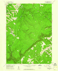
 1994 Sandy Ridge1997 Print · USGSSandy Ridge and the surrounding forest lands are captured in the late twentieth century as the industrial landscape of the Alleghenies evolved. Local historians can trace old transportation routes via the CONRAIL lines and find family landmarks like Mt Pleasant Cem and the small settlement of Glass City.
 - 2023 Map of Sandy Ridge, 2023 Print
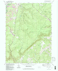
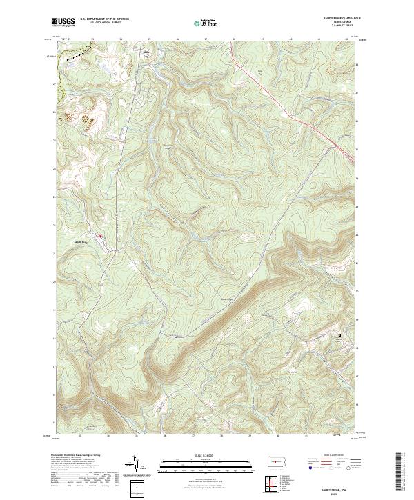 2023 Sandy Ridge2023 Print · USGSThe high ridges of Centre County come into focus during the early twenty-first century, showing a landscape shaped by narrow hollows and high plateaus. Researchers can trace local landmarks like Glass City, Mount Pleasant Cem, and the waters of Philipsburg Reservoir.
End of results
Showing maps 1-12
Top cities near Glass City
- Clearfield historical maps
- Tyrone historical maps
- Philipsburg historical maps
- Beccaria Township historical maps
- Warriors Mark Township historical maps
- Graham historical maps
See more
Frequently asked questions
- What are the different types of historical maps available for Glass City?
- What is the oldest map of Glass City?
- Where can I purchase historical maps of Glass City for my home or office?
- Where can I download high-res historical maps of Glass City?
- Are there historical topographic maps available for Glass City?
- Is there historical aerial imagery available for Glass City?
- Where are historical maps of Glass City sourced from?