1920s Maps of Taylor Township, Pennsylvania
Explore 5 historic maps of Taylor Township from the 1920s. These maps offer a rare glimpse into what life looked like during the 1920s — showing old roads, neighborhoods, homes, and landmarks that have changed or disappeared over time.
Whether you're researching your family's past, planning a metal detecting trip, or studying how Taylor Township's landscape evolved across the 1920s, these high-resolution maps are a powerful tool for exploring the history of this region.
- Focus on a specific era: All maps on this page are from the 1920s, giving you a focused view of this time period.
- See what’s changed: Compare century-old streets, trails, and buildings to today's modern landscape using overlays and satellite layers.
- Research with precision: Use these maps for genealogy, historical research, land use analysis, or educational projects.
- View, download, or print: Maps are fully viewable online in high resolution, and can be downloaded or printed for your own records.
Start exploring Taylor Township's history through authentic maps from the 1920s. This is your window into the past.
Taylor Township, PA maps
(5)- 1920 Map of Altoona, 1954 Print
 1920 Altoona1954 Print · USGSThe industrial and rail-heavy corridor of the 1920s is on full display as the Pennsylvania RR cuts through the mountains. Genealogists and local historians can trace family roots through numerous country schools like Beech Grove School and lost settlements such as Wopsononock or Fostoria.6 unique versions available
 - 1922 Map of Philipsburg
 1922 Philipsburg1922 Print · USGSPhilipsburg and the northern Allegheny coalfields are captured here in the early twenties during a period of heavy rail and mining activity. Genealogists can trace family locations through dozens of named rural schoolhouses like Klondike School and industrial sites including Cuba Mines and the Central RR of Pennsylvania.3 unique versions available
 - 1922 Map of Altoona
 1922 Altoona1922 Print · USGSThe industrial hub of Altoona and the steep slopes of the Allegheny Front are captured here in the early 1920s. Researchers can trace the extensive rail operations of the Pennsylvania railroad and locate numerous vanished rural landmarks like the Richland School and Grandview Cemetery.8 unique versions available
 - 1923 Map of Tyrone
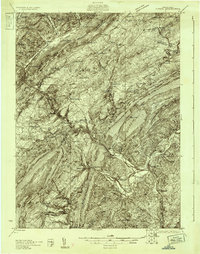
 1923 Tyrone1923 Print · USGSThe industrial and rail corridor of the Juniata Valley is captured here in the early twenties as it winds between massive ridges. Researchers can locate early iron landmarks like Huntingdon Furnace, local schools such as Kinch School, and the rail junction at Tyrone.4 unique versions available
 - 1929 Map of Tyrone
 1929 Tyrone1929 Print · USGSCentral Pennsylvania during the 1920s reveals a landscape defined by industrial rail towns and limestone valleys. Trace the route of the Pennsylvania Railroad past historic sites like Graziers Mill and Union Furnace.6 unique versions available
End of results
Showing maps 1-5 of 5
Top cities near Taylor Township
- Altoona historical maps
- Tyrone historical maps
- Philipsburg historical maps
- Bellwood historical maps
- Warriors Mark Township historical maps
- Graham historical maps
See more
Top neighborhoods of Taylor Township
Frequently asked questions
- What are the different types of historical maps available for Taylor Township?
- What is the oldest map of Taylor Township?
- Where can I purchase historical maps of Taylor Township for my home or office?
- Where can I download high-res historical maps of Taylor Township?
- Are there historical topographic maps available for Taylor Township?
- Is there historical aerial imagery available for Taylor Township?
- Where are historical maps of Taylor Township sourced from?