1990s Maps of Easttown Township, Pennsylvania
Explore 2 historic maps of Easttown Township from the 1990s. These maps offer a rare glimpse into what life looked like during the 1990s — showing old roads, neighborhoods, homes, and landmarks that have changed or disappeared over time.
Whether you're researching your family's past, planning a metal detecting trip, or studying how Easttown Township's landscape evolved across the 1990s, these high-resolution maps are a powerful tool for exploring the history of this region.
- Focus on a specific era: All maps on this page are from the 1990s, giving you a focused view of this time period.
- See what’s changed: Compare century-old streets, trails, and buildings to today's modern landscape using overlays and satellite layers.
- Research with precision: Use these maps for genealogy, historical research, land use analysis, or educational projects.
- View, download, or print: Maps are fully viewable online in high resolution, and can be downloaded or printed for your own records.
Start exploring Easttown Township's history through authentic maps from the 1990s. This is your window into the past.
Easttown Township, PA maps
(2)- 1992 Map of Valley Forge, 1998 Print
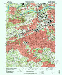 1992 Valley Forge1998 Print · USGSThe hallowed grounds of Chester County are captured here in the late twentieth century as suburban growth surrounds the Revolutionary War site. Genealogists can trace local landmarks like Abram Cem, St Monica's Cem, and the historic Great Valley Mills among the rising developments.
 - 1995 Map of Media, 1999 Print
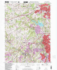 1995 Media1999 Print · USGSThe Delaware County suburbs of Media and Newtown Square appear in the mid-1990s as a landscape of established estates and modern developments. Genealogists and historians can trace institutional landmarks like Sleighton Farm School, the Fair Acres County Home, and Bowling Green Cem.
End of results
Showing maps 1-2 of 2
Top cities near Easttown Township
- Philadelphia historical maps
- Upper Darby historical maps
- Chester historical maps
- Norristown historical maps
- Radnor Township historical maps
- Horsham Township historical maps
See more
Top neighborhoods of Easttown Township
- Berwyn historical maps
- Waterloo Mills historical maps
- Leopard historical maps
- Daylesford historical maps
- Devon historical maps
Frequently asked questions
- What are the different types of historical maps available for Easttown Township?
- What is the oldest map of Easttown Township?
- Where can I purchase historical maps of Easttown Township for my home or office?
- Where can I download high-res historical maps of Easttown Township?
- Are there historical topographic maps available for Easttown Township?
- Is there historical aerial imagery available for Easttown Township?
- Where are historical maps of Easttown Township sourced from?