Old Maps of Bradford Township, Pennsylvania for Hiking & Exploration
Hike through history with 44 historic maps of Bradford Township. Explore old trails, ghost towns, and forgotten backroads — perfect for outdoor adventurers and local explorers.
- Rediscover forgotten places: Map out old mining camps, roads, and footpaths that no longer exist on modern maps.
- Layer with modern tools: Combine with LiDAR or satellite views to plan hikes through historical terrain.
- Made for exploration: Popular among hikers, overlanders, and local history lovers.
Use these maps to find adventure and explore the hidden past of Bradford Township.
Bradford Township, PA maps
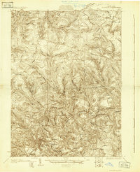
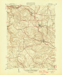
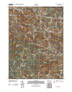
(44)- 1903 Map of Houtzdale, 1959 Print
 1903 Houtzdale1959 Print · USGSClearfield County was a hub of rail and river activity at the turn of the century as industrial towns expanded along the Allegheny Mts. Researchers can trace the early layout of Houtzdale, find family-named post offices like Oshanter P.O. Mitchells, and follow the winding Clearfield Creek.
 - 1905 Map of Houtzdale
 1905 Houtzdale1905 Print · USGSHoutzdale and the surrounding Clearfield County coalfields are captured here during their industrial prime at the turn of the century. Genealogists and historians can trace rail-dependent settlements and local post offices like Kephart P.O., Belsena Mills, and Brisbin.5 unique versions available
 - 1929 Map of Clearfield
 1929 Clearfield1929 Print · USGSThe riverfront and rail lines of central Pennsylvania come alive in this late 1920s survey of the West Branch Susquehanna River valley. Genealogists and historians can trace the foundations of local society through landmarks like the Leonard Waterford Sch and the rural crossroads of LeContes Mills.2 unique versions available
 - 1932 Map of Clearfield
 1932 Clearfield1932 Print · USGSClearfield and the West Branch of the Susquehanna are captured here in the early 1930s as a vital hub of rail and river industry. Researchers can trace ancestral locations through numerous rural landmarks like Lecontes Mills, Goshen Ch, and Mt Sinai Sch.4 unique versions available
 - 1944 Map of Glen Richey, 1956 Print
 1944 Glen Richey1956 Print · USGSClearfield County is shown during the mid-1940s as a landscape of winding creeks and ridge-top settlements connected by the B & O railroad. Genealogists can trace family names at Baughman Cem or locate long-gone rural schools like Evergreen Sch and Pleasant Ridge Sch.5 unique versions available
 - 1945 Map of Wallaceton, 1956 Print
 1945 Wallaceton1956 Print · USGSClearfield County's upland mining and rail corridor is captured here at the end of the war. Genealogists and researchers can trace family landmarks like Salem Ch, Eagle Eye Sch, and the junction at Wallaceton before modern development changed the landscape.4 unique versions available
 - 1946 Map of Glen Richey
 1946 Glen Richey1946 Print · USGSClearfield County's upland valleys and winding waterways are captured here at the end of World War II. Genealogists and local historians can trace rural family sites from Glen Richey to Boardman, including numerous schools like Bethlehem Sch and several cemeteries.2 unique versions available
 - 1946 Map of Wallaceton
 1946 Wallaceton1946 Print · USGSClearfield County at the close of the 1940s is shown here as a series of tight-knit townships and rural school districts. Researchers can trace the exact locations of many local landmarks including West Decatur P O, Eagle Eye Sch, and Salem Ch.2 unique versions available
 - 1953 Map of Pittsburgh
 1953 Pittsburgh1953 Print · USGSWestern Pennsylvania's industrial landscape at the start of the fifties shows the steel and rail corridors between Pittsburgh and Altoona. Trace family roots in river towns like Tarentum or follow the Pennsylvania Turnpike across Laurel Hill.
 - 1954 Map of Pittsburgh
 1954 Pittsburgh1954 Print · USGSWestern Pennsylvania in the early fifties remains a powerhouse of heavy industry and vital transit corridors. Genealogists and historians can trace the rail-and-river network connecting Pittsburgh, Johnstown, and Altoona via the Pennsylvania RR and the Lincoln Highway.2 unique versions available
 - 1957 Map of Warren, 1964 Print
 1957 Warren1964 Print · USGSThe northern Pennsylvania oil and timber country comes into focus in the mid-fifties, showing the region before modern highway expansions. Trace the industrial rail networks of the Pennsylvania RR and the early Allegheny River Reservoir near Warren and Oil City.4 unique versions available
 - 1958 Map of Pittsburgh
 1958 Pittsburgh1958 Print · USGSWestern Pennsylvania in the late fifties shows an industrial heartland defined by the confluence of the Allegheny River and Monongahela River. Researchers can trace the sprawling rail networks of the Pennsylvania RR and find established towns like Butler, Latrobe, and Windber.5 unique versions available
 - 1958 Map of Warren
 1958 Warren1958 Print · USGSNorthern Pennsylvania’s timber and oil country is captured here during the late fifties, showing the interplay of industrial valleys and vast state forests. Genealogists can trace family connections across the Cornplanter Indian Reservation or through rail hubs like Oil City and Saint Marys.
 - 1959 Map of Warren
 1959 Warren1959 Print · USGSNorthern Pennsylvania's oil and timber country comes alive in this late-fifties study of the forest-clad plateaus. Trace the historic Cornplanter (Indian Reservation), the sprawling Oil Field, and the rail lines of the Pennsylvania RR.2 unique versions available
 - 1959 Map of Pittsburgh
 1959 Pittsburgh1959 Print · USGSWestern Pennsylvania in the late fifties is captured here at the height of its industrial era. Genealogists and historians can trace the riverfront growth of Pittsburgh, the rail works at Altoona, and the mountain gaps of Laurel Hill.
 - 1959 Map of Lecontes Mills, 1960 Print
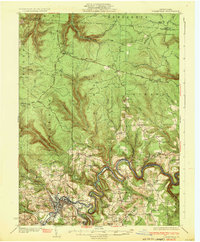
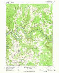 1959 Lecontes Mills1960 Print · USGSThis late-fifties survey of the Clearfield County highlands shows a landscape defined by the winding West Branch Susquehanna River and a booming coal industry. Researchers can trace the New York Central rail line through the Shawville Tunnel to rural outposts like Needful and Gallows Harbor.6 unique versions available
 - 1959 Map of Clearfield, 1961 Print
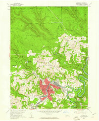 1959 Clearfield1961 Print · USGSClearfield and the Susquehanna River valley are captured here at a peak of industrial activity in the late fifties. Genealogists and historians can trace family-named sites like the Baney Settlement or locate records at Hillcrest Cem and St Francis Sch.5 unique versions available
 - 1964 Map of Pittsburgh
 1964 Pittsburgh1964 Print · USGSWestern Pennsylvania in the late fifties and early sixties shows a landscape of powerful river industries and expanding highways. Genealogists and historians can trace the rail corridors of the Pennsylvania RR through industrial hubs like Johnstown, Altoona, and Nanty Glo.
 - 1971 Map of Warren
 1971 Warren1971 Print · USGSNorth Central Pennsylvania is captured here in the early seventies, showing a landscape defined by industrial centers and massive state forests. Genealogists and historians can trace the rail lines of the Penn Central and Erie Lackawanna connecting towns like Warren, Kane, and Du Bois.
 - 1983 Map of Clearfield, 1984 Print
 1983 Clearfield1984 Print · USGSPennsylvania's coal and timber heartland is captured in the early eighties as industrial hubs like Du Bois and Saint Marys thrived among the state forests. Genealogists can locate family landmarks like Morningside Cemetery, the old works at Dagus Mines, and the rural community of Byrnedale.
 - 1984 Map of Tyrone, 1985 Print
 1984 Tyrone1985 Print · USGSCentral Pennsylvania in the mid-eighties shows a rugged landscape defined by the industry of Altoona and the ridges of the Appalachians. Genealogists and historians can trace the rail corridors of CONRAIL and locate vanished family homes near Glendale Lake or within Sinking Valley.
 - 1993 Map of Glen Richey, 1994 Print
 1993 Glen Richey1994 Print · USGSClearfield County in the early 1990s reveals a landscape shaped by coal mining and winding river valleys. Genealogists and local historians can trace family connections through sites like Thompson Cem, the Mt Zion Ch, and the settlement at Glen Richey.
 - 1993 Map of Wallaceton, 1994 Print
 1993 Wallaceton1994 Print · USGSClearfield County's coal country comes into focus in the early nineties, showing a landscape shaped by rail lines and resource extraction. Genealogists and local historians can locate many rural landmarks, including Spring Valley Cem, Bigler, and Summit Hill Ch.
 - 2000 Map of Lecontes Mills, 2001 Print
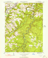
 2000 Lecontes Mills2001 Print · USGSClearfield County at the turn of the century shows a unique mix of heavy industry and rural Pennsylvania life along the West Branch Susquehanna River. Genealogists and historians can trace family roots through sites like Lecontes Mills, Shiloh Cem, and the old Township Sch.
 - 2010 Map of Wallaceton, 2010 Print
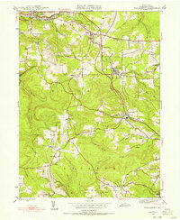
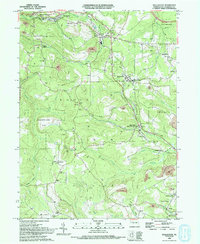
 2010 Wallaceton2010 Print · USGSCovers Bradford Township, including Bigler, Wallaceton, and other nearby areas
Showing maps 1-25 of 44
Top cities near Bradford Township
- Clearfield historical maps
- Philipsburg historical maps
- Curwensville historical maps
- Beccaria Township historical maps
- Graham historical maps
- Bigler historical maps
See more
Top neighborhoods of Bradford Township
- Needful historical maps
- Shiloh historical maps
- Dale historical maps
- Pine Top historical maps
- Gallows Harbor historical maps
- Woodland historical maps
See more
Frequently asked questions
- What are the different types of historical maps available for Bradford Township?
- What is the oldest map of Bradford Township?
- Where can I purchase historical maps of Bradford Township for my home or office?
- Where can I download high-res historical maps of Bradford Township?
- Are there historical topographic maps available for Bradford Township?
- Is there historical aerial imagery available for Bradford Township?
- Where are historical maps of Bradford Township sourced from?